ROUBEN GALICHIAN (GALCHIAN)
Independent researcher and cartologist
Hon. Doctor of NAS RA
rgalichian@yahoo.com
Abstract
In any given part of the world, forced demographic changes to the ethnic population inevitably result in changes to the local linguistics as well as the evolution and alteration of toponyms. The resulting changes can give politicians and extremists the possibility to exploit the changes to augment their claims and incursions.
In extreme cases, such as the “scorched earth” policy adopted by Shah Abbas of Iran in the so called “protectorates” of Nakhijevan, Syuniq and Karabakh, the Armenian ethnic population was decimated. The elimination of the ethnic Armenians gave an opportunity to the Turkish speaking remaining minority of the local population the possibility to claim ownership of these lands.
Through the citation of historical facts and cartographic evidence, the article discusses the reasons for the naming of Lake Sevan in Armenia as “Gokcha”, and the exploitation of this new toponym in an attempt to prove ownership of the lake, through the presentation of dubious documents and arguments.
Keywords
Armenia, Sevan, Azerbaijan, Gökcha, Shah Abbas, Cartography, Toponyms.
Introduction
Recently, the President of the Republic of Azerbaijan announced that in all maps of Tsarist Russia the name of the lake presently located in Armenia and called “Sevan”, is shown as lake “Gökcha” or “Gokcha”. Hence concluding, that as this is an Azerbaijani name, it is proof that the lake belongs to the Republic of Azerbaijan.
Only in-depth analysis of the Tsarist Russian and European maps of the eighteenth to twentieth century could possibly clarify the issue, separating fact from fiction. The following study confirms the source of the name of “Gokcha” and its use during two centuries of Persian occupation of the South Caucasus, also showing that the majority of European and Tsarist Russian maps, in fact, display both names “Gokcha” as well as “Sevan” – for the lake in question.
There is, moreover, another problem with the abovementioned claim, and that is that all the maps published between 1700 and 1918, in the regions presently occupied by the Republic of Azerbaijan, there is no such toponym. It is a fact that during that period, the toponym “Azerbaijan” had only been given to the northwestern province of Iran, located south of the Arax River, while the region of Baku and surrounding area was generally named “Shirvan”.
The Analysis
Two Middle Eastern military powers of the fifteenth and sixteenth centuries, the Ottoman and the Persian empires, had usurped the territory of Great Armenia and often went to war, each trying to conquer more of the Armenian lands. All fighting took place on the territory of Great Armenia, which had lost its independence and was at the mercy of the two empires. As a result, it became impossible for the Armenian peasants and citizens living in the territory of their historical homeland to take full ownership of their property and utilize and cultivate their lands, or to lead a peaceful life.[1]
In the early seventeenth century, the Persian king Shah Abbas the Great conquered most of the South Caucasus, including Eastern Armenia, and in order to retain control of the territory, he planned and implemented a “scorched earth” policy, to make the territory uninhabitable and useless for the Ottomans, so that they would not even wish to recapture that region.[2]
During the years of 1604-05 Shah Abbas organized large-scale deportations, whereby the majority of the Armenians of Syunik, Ayrarat, Nakhijevan and Artsakh regions of Armenia, more than 300,000 souls, were deported to Iran and were settled in the northern, western and central regions of this country. The peasants and the working class were resettled in villages and towns, while artisans and craftsmen as well as traders and merchants were directed to the capital Isfahan, where a specially chosen district was allocated to the Armenians.[3] The plan was to benefit from the professional skills of master craftsmen, as well as encouraging Armenian merchants to continue trading with Russian and European merchants, with whom they already had close contacts and ties, thus promoting trade between Iran and the West. To this end for a period of time he gave the Armenian merchants the monopoly of exporting Iranian silk.[4]
Thus, the indigenous Armenian population of Eastern Armenia was drastically reduced, their towns and villages being gradually reinhabited by the people of Iranian Azerbaijan – the old Atropaten/Media – as well as other Turkish-speaking tribes from Central Asia.[5]
As a result of these demographic changes, during the 18th and 19th centuries, “Geghama”, the ancient name of the Armenian lake “Sevan” was Turkified and in their colloquial language became “Gokcha”. All this time, the Armenians continued to call it “Sevan”.
Since those who remained in the area and the newcomers were mostly Turkish speakers, during the two hundred years under Iranian rule many of the toponyms gradually changed under the majority Turkish-speakers to new names given by the newcomers. Such is the reason that during the eighteenth and nineteenth centuries the name of the Armenian lake “Sevan” or “Geghama” was Turkified and became “Gokcha” or “Gökcha” in their colloquial language, while the Armenians continued to call it “Sevan”.[6]
Today, some authorities of the Republic of Azerbaijan declare that the name of Sevan is actually “Gökcha”, which is allegedly confirmed by all the maps of Tsarist Russia. This study proves that this naming not to be fully correct. As seen on the accompanying maps, during the eighteenth to twentieth centuries. on most maps of tsarist Russia, the names “Sevan” and “Gökcha” are mentioned in conjunction with each other, indicating that the Armenian speakers call it “Sevan”, while the Turkish speakers of the last two centuries had changed it to “Gokcha” or “Gökcha”.
Concerning the recent claim that “since the name “Gökcha” is Turkish, therefore the lake belongs to Azerbaijan”, its proponents should be reminded that on any of the Tsarist Russian or other European maps of this particular region, prior to 1918 there was no country named “Azerbaijan” to the north of the River Arax. On the same maps the countries mentioned in the region are Georgia, Armenia, Shirvan and the Iranian province of Azerbaijan.[7]
Maps of the region
All the regional details reprinted herein have been taken from well-known Russian, Ottoman and European maps. The originals are held in the Matenadaran, Yerevan․ Exceptions have been mentioned.
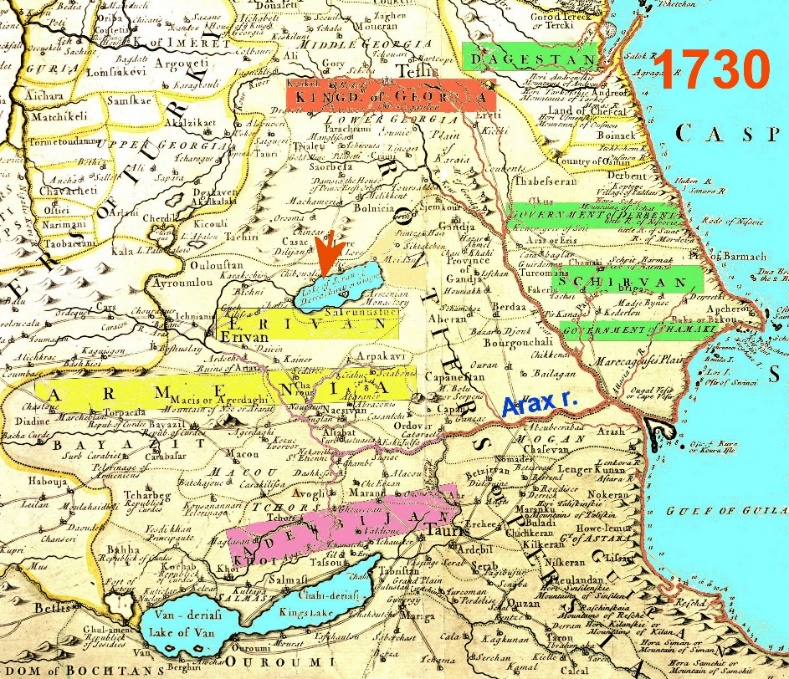
01 – Frenchman De L’Isle’s map of the Caucasus published in 1730, where the lake is called “Sevan Daryiachirin [sweet water], Giagum [Gegama]”, and the current Azerbaijan Republic is ruled by the Iranian khanates, highlighted in green. The region called “Azerbaijan” is a province of Iran, located south of the River Arax, highlighted in maroon. There is no “Lake Gokcha” on this map.
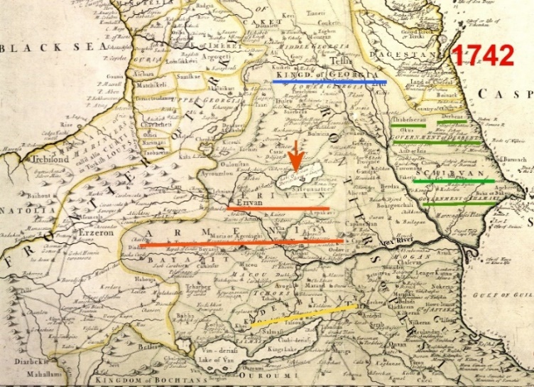
02 – English map of Senex, 1742, showing the Caucasus, where the lake is named “Sevan or Daryachirin [sweet water], Giagum [Geghama]”. The area of the Republic of Azerbaijan is occupied by Muslim khanates, underlined in green. The region called “Azerbaijan” is the northwestern province of Iran, underlined in yellow, located south of River Arax. The name “Lake Ghokcha” does not exist.
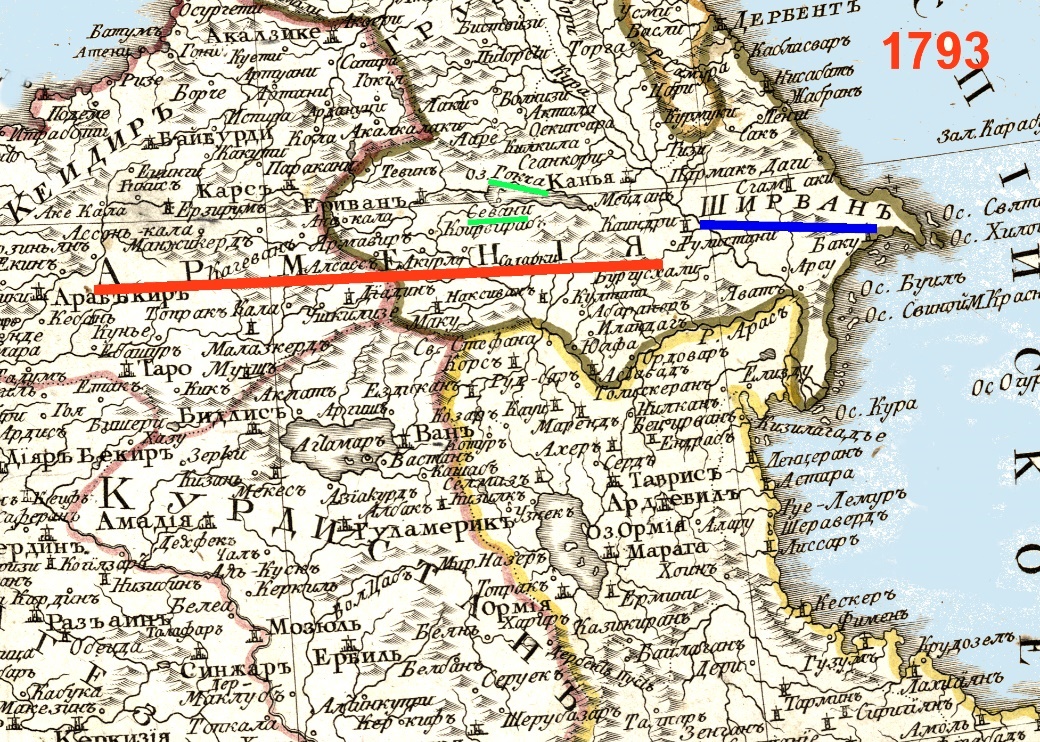
03 – Tsarist Russian map of 1793. The lake is called by two names, separately, “Sevan” and “Gökcha”, both underlined in green. The name of “Armenia”, extending from Euphrates to Sevan, is underlined in red. “Shirvan” is underlined in blue, as the name of the region of the present-day Azerbaijan – the latter name is missing from the area altogether.
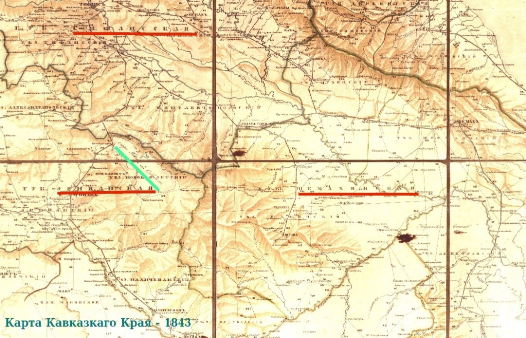
04 – “Map of the Caucasus region” of Tsarist Russia, published in 1843. Here the name of the lake is “Sevan or Gökcha”, underlined in green. The tsarist Transcaucasia, Georgia, Yerevan and Shamakhi gubernias are underlined in red on the map. The name Azerbaijan as a gubernia or region is missing from the map.

05- The map of Pierre M. Lapie, from Pierre Amedee Jaubert’s book “Travels to Armenia and Iran” showing his route from Constantinople to Tehran via Armenia and the South Caucasus, published in Paris, 1821.
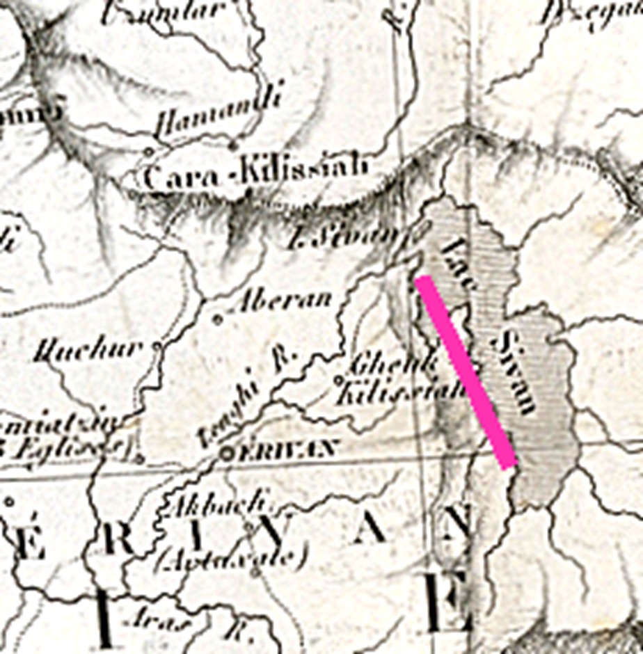
06 – Detail of the region of Sevan from the above map.
Early during the nineteenth century the French traveler Jaubert travelled from Europe to Iran, passing through Armenia and the South Caucasus. His friend and cartographer Pierre Lapie produced the map reprinted in image 05 above, showing the regions that Jaubert travelled through.
On this map the name of Greater Armenia is underlined in red. The region of present-day Republic of Azerbaijan is entitled “Shirvan” and is underlined in green, while the name “Azerbaijan” indicate a province of Iran south of the River Arax, and is underlined in blue.
The detail of the region of Lake Sevan is shown in map 06 above, where the name of the city and region of “ERIVAN”/Yerevan and its proximity to the lake can also be seen. On the map the lake has been misspelt “Sivan”.
07 – German cartographer Heinrich Kiepert’s “Ottoman Empire map” dated 1844. This is the section from the map showing the region of the South Caucasus. The name of the lake is indicated as “Sevan or Gökça”. The names of the countries specified in the area are “Armenia” – underlined in red, and “Georgia” – underlined in green, while “Azerbaijan” denotes the the Iranian province, south of the River Arax (underlined in blue). The toponym “Shirvan” is marked on the territory of the present-day Republic of Azerbaijan, underlined in black.
08 – A detail from the same map by Kiepert, translated into Ottoman Turkish and published in
1855. On this map the name of the lake is indicated only as “Sevan”, underlined in dark blue. And among the local countries, only “Armenia” is indicated, underlined in red.
Original of the map is in the National Library of Vienna.
It is interesting that the original map named the lake “Gokcha or Sevan”, but the Azerbaijan-allied Turkish translator has named the lake simply as “Sevan”.
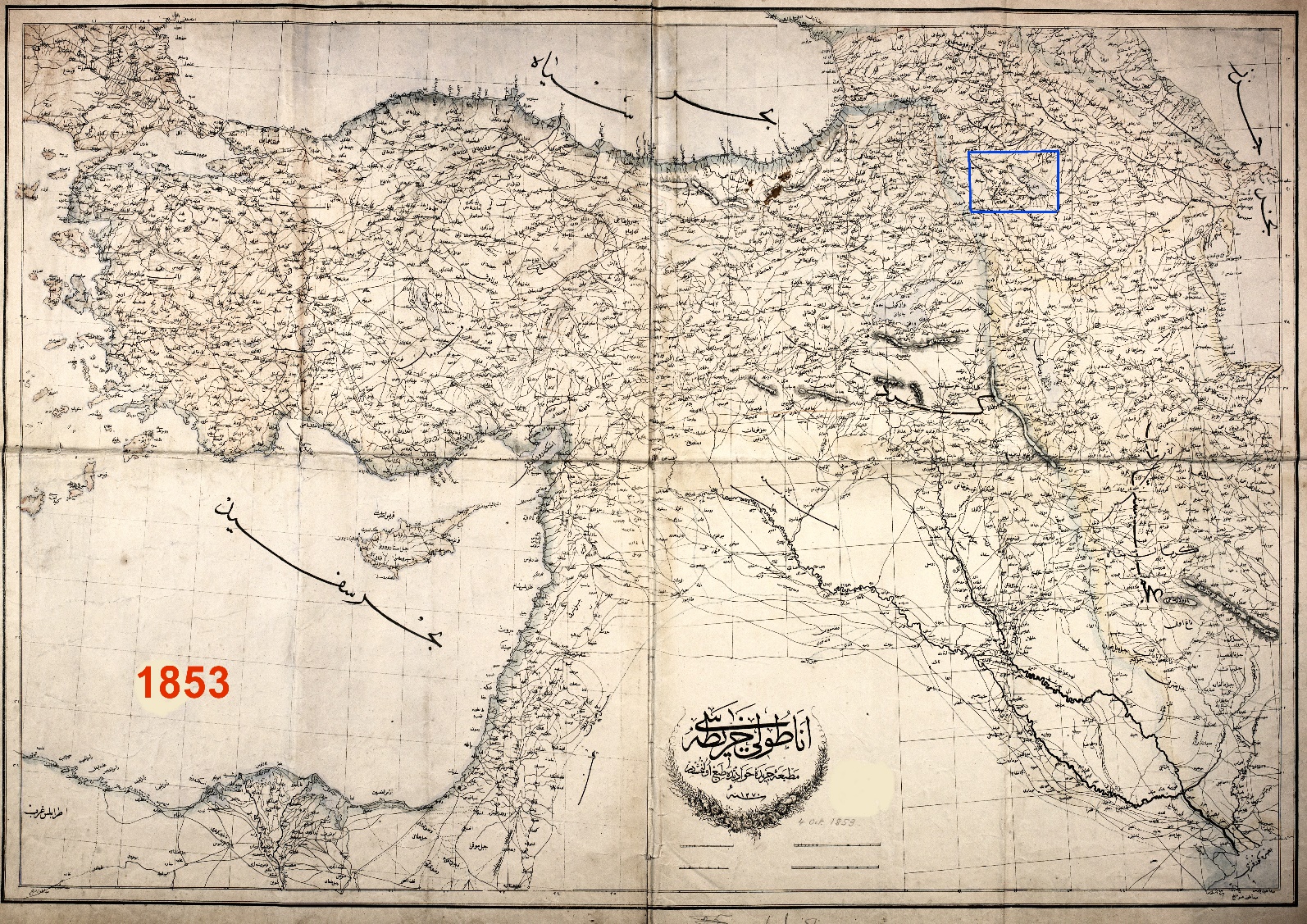
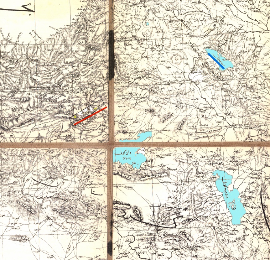
09– Another map of the Ottoman Empire in Turkish, dated 1853.
As seen on map 10 below, the detail of map 09 above, indicated by a blue frame, the name of the Turkish name of the lake in question has been given only as Sevan, that is “Sivane Goli”, underlined in red. The other Turkish toponym, “Gokcha” claimed by some, has not been mentioned on this Turkish map. The toponym “Yerevan” also appears, underlined in blue.
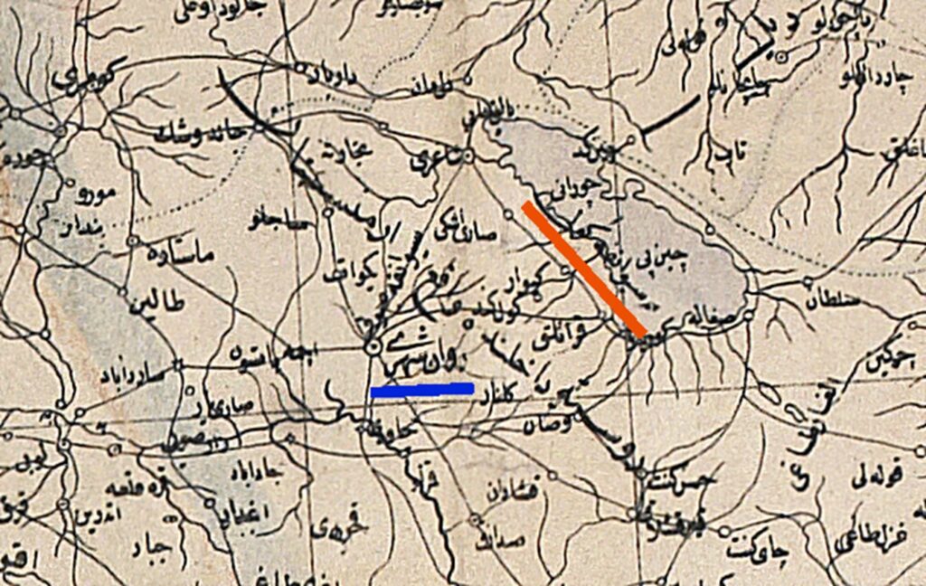
10 – Detail of the region of Sevan, from map 09.
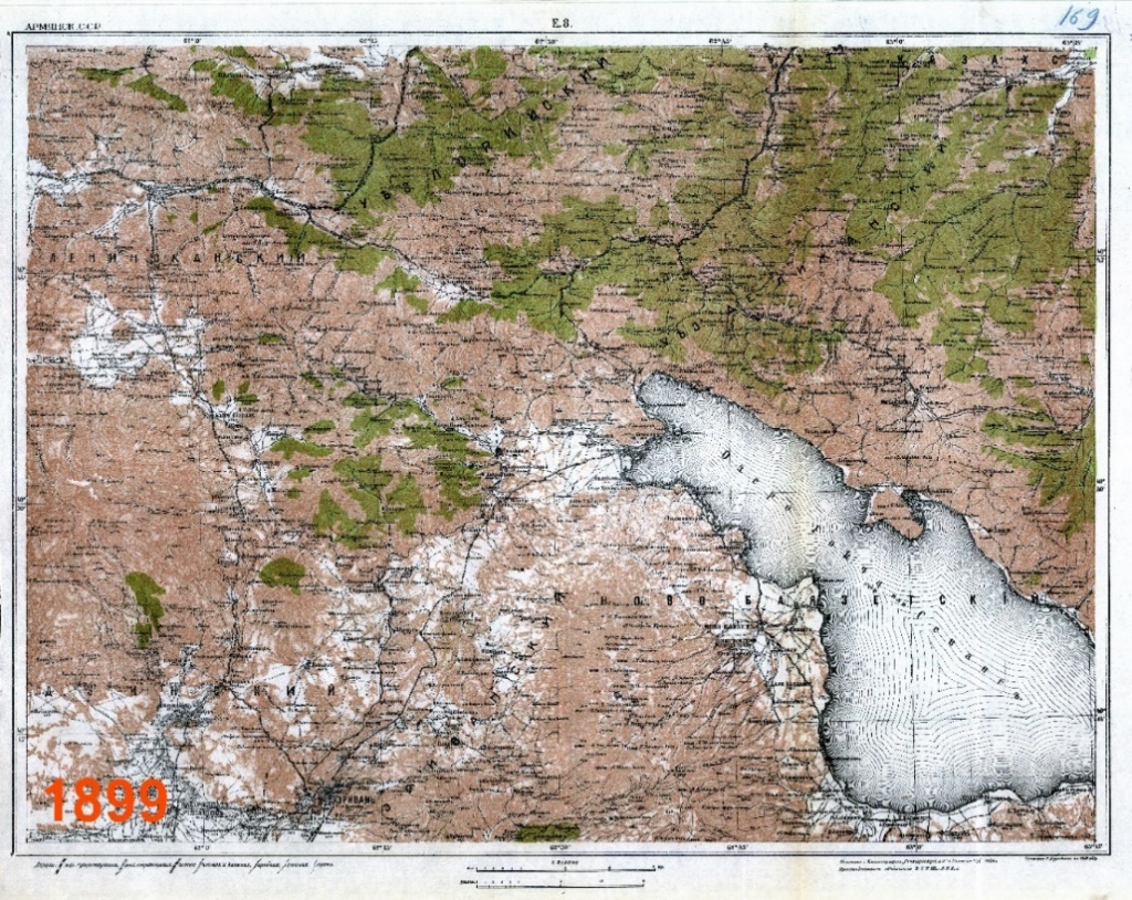
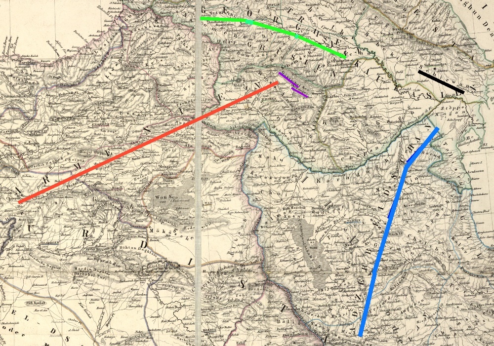
11 – A Tsarist Russian map of the area of Sevan, from a set of detailed maps of Armenia, originally published in Tsarist Russia, in 1899. The same maps were, however, also published by the USSR in 1926. On this map the lake is called by both its names, “Gökcha or Sevan”.
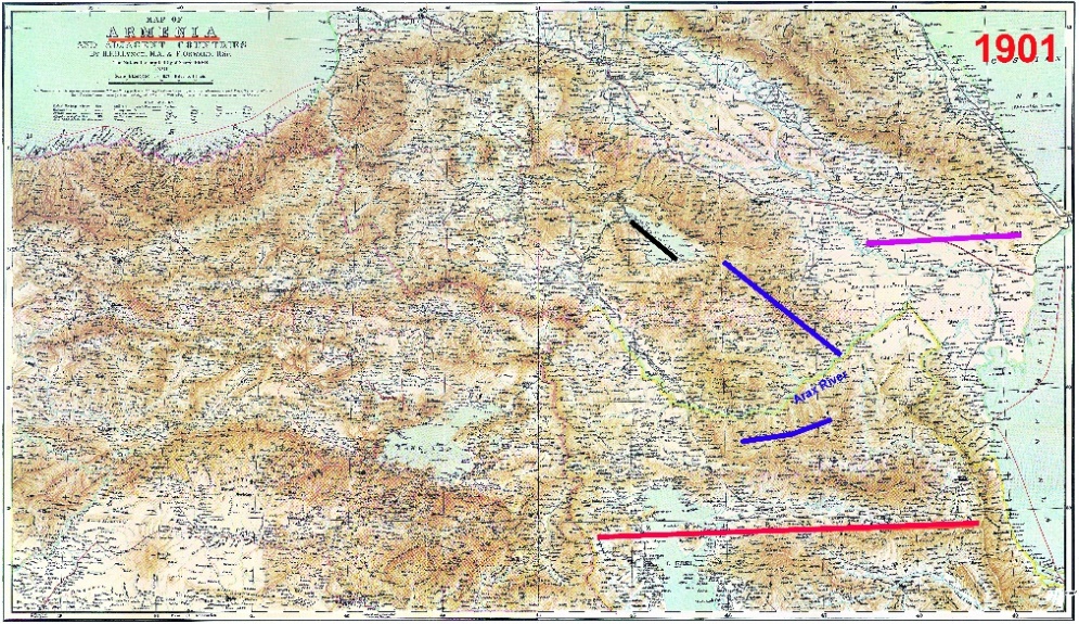
12 – This British map is by Lynch, published in 1901 inLondon. The map is entitled “Armenia and neighboring countries”. Here, too, the lake is called “Sevan or Gökçe”, underlined black. The names of the region#s countries are “Shirvan is underlined purple, “Karabakh” and “Gharadagh”, both underlined in blue, the former is placed north of River Araxes and the latter, south of the river. The name “Azerbaijan” is underlined red and placed south of River Arax, as one of the provinces of Iran.

13 – Kiepert’s 1916 map of the region. Here the lake is called “Sevan or Gökça”, underlined in black. The name “Armenia” is underlined in red. The regio of “Karabakh” is underlinedin yellow and is to the north of the River Arax. “Shirvan” is underlined in white and refers to the region of present-day Azerbaijan. On the map the name “Azerbaijan” denotes the Iranian province, located south of the River Arax, highlightedin green, where the region of “Gharadagh” is also shown, underlined in blue.
The above is one of the last European maps of this part of the world prior to the establishment of communist rule in the Caucasus and before the founding of the Republic of Azerbaijan in 1918.
Conclusion
When discussing maps, one should be careful to consider all the variants of maps of the same region, prepared and published by various cartographers and specialists, as it is through the comparison of alternative maps that one can be properly informed about the veracity of various claims and statements.
Earlier historical records show that during the Middle Ages the Armenians called the lake, “Geghama” or “Gegharquniats”, and since the seventeenth century it was also known as “Sevan”. However, until the fifteenth or sixteenth centuries, most Western medieval cartographers called the lake by the name “Lychnitis”.
In later times the name generally used has either just been “Sevan” or by a combination of both names, as “Sevan or Ghokcha”, and only in very few instances as merely “Gokcha”.
Whatever its name, the lake could hardly belong to a country which was established in 1918!
BIBLIOGRAPHY
- Babaie, Baghdiants et al – Slaves of the Shah. I.B. Tauris, London: 2004.
- Galichian, Rouben. The Clash of Histories in the South Caucasus. Bennett & Bloom, London: 2012,19-28.
- Galichian, Rouben. Historic Maps of Armenia. I.B. Tauris, London: 2004.
- Galichian, Shahen. “A Tradition of Respect”, Geographical, published by the RGS January London: 1995, 26-28. .
- Kasravi, Ahmad. “Azeri or the Ancient Language of Azerbaijan”, Collection of 78 Articles and Lectures, Ketabhaye Jibi, Tehran: 1976 (in Persian).
- Ptolemaeus, Claudius. Geographgia. Ulm: 1486.
- Tsutsiev, Arthuir. Atlas of Ethno-Political History of the Caucasus. Yale University Press, New Haven and London: 2014.
- Walker, Christopher J. Armenia, Survival of a Nation. Croom Helm, London: 1980.
ՍԵՎԱՆԱ ԼՃԻ ԳՅՈԿՉԱ ԱՆՎԱՆՄԱՆ ՄԱՍԻՆ
Ռուբեն Գալչյան (Գալիչյան)
Անկած հետազոտող, քարտեզագետ
ՀՀ ԳԱԱ պատվավոր դոկտոր
rgalichian@yahoo.com
Ամփոփում
Վերջերս Ադրբեջանի կողմից հայտարարվեց, որ Սևանա լճի անվանումը ցարական Ռուսաստանի բոլոր քարտեզներում նշված է որպես «Գյոկչա» և քանի որ սա ադրբեջանական անվանում է, հետևաբար Սևանն Ադրբեջանի տարածքում է գտնվում։
Հոդվածը ներկայացնում է թե որտեղի՞ց և ե՞րբ է եկել այդ նոր անվանումը և այն, որ հետազոտված և ցուցադրված ցարական քարտեզների ճնշող մեծամասնության մեջ լիճն անվանված է «Գյոկչա կամ Սևան»։ Իսկ այդ նույն քարտեզները նաև փաստում են, որ տվյալ տարածքում, այսինքն Արաքսից հյուսիս, այդ օրերին, ընդհուպ մինչև 1918 թ․ Ադրբեջան անունով երկիր գոյություն չի ունեցել, իսկ Արաքսից հարավ գտնվող Ադրբեջան անվանված շրջանը, նշում է՝ որպես Իրանի պատմական նահանգներից մեկը, որը հայերենում անվանվում է «Ատրպատական»։
Բանալի բառեր՝ Հայաստան, Սևան, Ադրբեջան, Շահ Աբբաս, Գյոկչա, Քարտեզագրություն, Տեղանուններ։
Walker, Christopher J. Armenia, Survival of a nation. Croom Helm, London: 1980. ↑
Galichian, Shahen. “A Tradition of Respect”, Geographical, published by the RGS January London: 1995, 26-28. ↑
The district was and still is called New Julfa, since most of the merchants originated from the Armenian town of”Julfa in Nakhijevan, just north of the Arax River. ↑
- Babaie, Baghdiants et al – Slaves of the Shah. I.B. Tauris, London: 2004. ↑
Kasravi, Ahmad – “Azeri or the Ancient Language of Azerbaijan”, Collection of 78 Articles and Lectures, Ketabhaye Jibi, Tehran: 1976 (in Persian). ↑
The name Geghama or Gegharquniats appears in the first Armenian geographical work Ashkharhatsuyts, penned in the seventh century, indicating present-day Lake Sevan. This naming can be seen in all versions of the manuscript kept in the Matenadaran in Yerevan, the Library of the Mekhitarist order in Venice, as well in the Armenian Patriarchate Library of Jerusalem, as well as in other libraries all over the world. ↑
Galichian, Rouben. The Clash of Histories in the South Caucasus. Bennett & Bloom, London: 2012,19-28. ↑