A Cartogrpahic Study
Rouben Galichian
2023 – Yerevan
Index of Contents
Authors Preface
A – Genberal information
B – Analysing the old maps
C – Conclusion
NATIONAL ATLAS OF AZERBAIJAN – BAKU, 2014
A – General Provisions
This atlas of Azerbaijan was published in Baku, 2014. It has a volume of about 450 pages, of which the first part, pages 16-31, contains general information about Azerbaijan, and the second part is dedicated to brief historical information of Azerbaijan, and after that, there are pages of ancient maps prepared by foreign geographers and cartographers, and are supposed to represent the facts of Azerbaijan’s ancient and historical past. These are posted from page 33 to page 61.
The last thirteen pages of these, from pages 49 to 61, contain maps recently drawn by cartographers of Azerbaijan, which are prepared as advertisements to present their supposed millennia olf history according to their own invented “facts” about the matter. However, these seemto be extremely biased, because the names of the two real and ancient countries of the region, Armenia and Iran, are completely missing from them. These are countries which are always considered and presented among the ten oldest countries of the world.
The names of these two countries are generally removed from the maps and the entire area of the south of the Caucasus Mountains well into the centrel of Iran is marked as Azerbaijan or Azeri khanates and kingdoms. These fabricated facts come to confirm the fact that Atlas is far from serious work.
Let’s remember that until 1918, a territory called Azerbaijan did not exist north of the River Arax. Furthermore, the historians of the atlas even call the Iranian royal families Azeri and namel almost half of the territory of Iran “Azerbaijan”.
Any cartographer, who has had the opportunity to study ancient and medieval maps in various libraries and museums of the world, could confirm without a doubt that among the tens of thousands of maps, there is only one map, drawn in 1844, found in a SDUK British atlas, the name “Azerbaijan” icould be seen written between Armenia and Georgia, which, however, was rectified in the subsequent maps of the atlas. Cartographers of Azerbaijan have made this unique and erroneous map their reference and everprresent evidence, which they all refer to and raise everywhere.
Let’s not forget that until the end of the 19th century, the present territory of Azerbaijan was called Shirvan in the European, Islamic and Ottoman maps, and in the maps of Tsarist Russia made between 1828 and 1918, when they divided the South Caucasus into administrative regions and goubernias, nowhere the name “Azerbaijan” can be found. The names of the provinces are based only on the names of the large cities of the particular region.
In all Ottoman maps of the nineteenth century, the northeastern part of their country is called Armenia, and, as mentioned above, the territory of present-day Azerbaijan is called “Shirvan”. The toponym Azerbaijan is given only to the northwestern province of Iran, located south of Arax River. See Armenia, Azerbaijan and Turkey, Addressin Paradoxes in Culture, Geography and History, 2020, Yerevan. (R. Galichian, 2020, London).
Before considering the historical maps part of the atlas, it is necessary to reveal the general approach of the authors of the volume towards maps, which may be considered as their general approach towards all historic maps. This subject is the map of the Republic of Azerbaijan in part two of the atlas, pages 18 and 19, represented as Image 01.
This map generally follows the 1970s maps of the USSR Military Staff. After 1936, three Azerbaijani enclaves appeared on the maps of Armenia, which are Eskipara, Barkhudarlu and then Tigranashen-Kyarki. These three enclaves are shown with enlarged borders on the map above, marked with green arrows.
However, the Artsvashen enclave, which is indicated in USSR maps as an Armenian enclave located inside the territory of Azerbaijan, is indicated in the above map as an internal part of Azerbaijan in general, which has no physical or other connection with Armenia. This area is highlighted in blue with a blue arrow. Thus, Azerbaijan, contrary to its own official recognition, excludes the existence of Artsvashen in the atlas, questioning the reliability of the atlas.
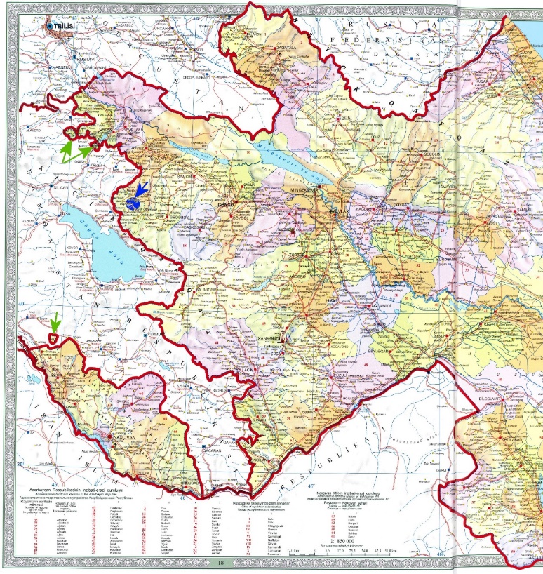
01 – Map of present-day Azerbaijan on pages 18-19 of the atlas, without Artsvashen.
B – Study of old maps in the Atlas
As mentioned, the second part of the atlas is devoted to history and historical maps. Thus, from page 34 to page 38 are Azerbaijani monologues of historical events, and from page 39 onwards, without any preface, ancient maps are displayed. The text about the importance of including the old maps and the related explanations and reasons for their presence in the atlas can only be found on page 49, which is only after the pages showing the reproductions of the historical maps and their related texts and discrptions.
According to the text, in the sixth century, the Persian king Anushirvan founded the Caucasian Atrpatan Union. Below is the ful text of that paragraph,
from the first summary on page 49.
In the sixth century, the Persian king Anushirvan founded the Caucasian Atrpatan Union, which according to the Arab-Persian tradition includes Northern Azerbaijan, Aghvank, and South Azerbaijan, which was called Atrpatan. During the days of the Caliphate, the name Azerbaijan included North and South Azerbaijan.
This is a completely invented theory, because all Arab and Persian sources, cartographers and geographers on every text and map make Aghvank-Arran (in the west known as Coaucasian Albania) a territory located north of Araks and Kura Rivers, while Azerbaijan is always located south of Araks River, as the northwestern part of Iran, as a province of that. Until the year 1918, the name South or North Azerbaijan cannpt be found anywhere or on any map.
It should also be noted that all Arab and Persian cartographers and geographers in their maps of the Caucasus, to the west of those two territories and in the texts of the named maps, on all maps mention the neme of Armenia, which was removed from the list contained in the atlas, due to the displeasure of the authors of the atlas.
The last paragraph on page 49 of the text introducing the old maps states the following.
The maps in the book are collected from xxxxxxxxx sources.
In the text of the English language, instead of the same word xxxxxxxxx, it should have been written incontrovertible [certain], but the prefix in remained in the upper line and the word controvertible appears at the beginning of the other line, which males it [uncertain].
B-1. Atlas Page 39
In the second paragraph on the left side of the page, it is stated:
Strabo is the first to mention the Caucasian peoples: “The historical cartography of Azerbaijan has been widely explained by early and medieval Arab and Persian historians. The maps prepared by Arab, English, German and other travelers represent the result of the pens of advanced scientists of different eras.
Historical geography has the greatest role in restoring the historical borders of Azerbaijan.
There are several inaccurate statements in the above text which are as follows.
I. The Caucasian peoples are mentioned in Strabo’s works, but the name Azerbaijan is not mentioned anywhere in any of his writings or works.
II. No Arab, Persian or European traveler mentioned the name Azerbaijan in their work. If this name is mentioned anywhere, it is represented as Atropaten Province of Iran.
III. In historical geography and cartography, from Strabo to Marco Polo, Clavijo, Schiltberger, Istakhri, Masudi, Ibn Battuta, Kyatip and Evliya Celebi, nowhere the name Azerbaijan was appeared in the territory north of Arax.
B-2. Page 39. – Babylonian clay tablet
The upper image on the right side of the page is a Babylonian clay tile, claimed to be made in 8th and 7th centuries B.C.E., regarding which the explanation of the atlas says:
Among the regions mentioned are Babylon, Assyria and Urartu…. which is probably a fragment of a detailed map.
- Having said this, the author is probably looking for a reason why the name Azerbaijan does not appear on the map at all, the real reasons for which are as follows. The name Azerbaijan generally appeared on maps in the second-third centuries, under the name Atropaten or Atrpatena, always referrring to the old kingdom of Media, a consituent region of Iran. After the Arab invasion, the name of this province of Iran was eveolved and became Arderbigan, Adherbijan and Azerbaijan, which was not actually the name of not a country, but that of the neighbouring province of Iran. Let us remember that in older and medieval times smaller divisions of countries, such as provinces were generally not included on maps.
- The author of the atlas directs the reader to the fact that the country of Urartu mentioned on it may be Azerbaijan. However, they did not pay attention to the fact that the German scientist Eckhard Unger, who analyzed the map and the text, translated the name of Urartu as Armenia (see Imago Mundi, Berlin, No.2, 1937, p.2).
- This reality also documented in 521 B.C.E. in Behistunian inscription of the Persian king Darius II near the city of Kirmanshah, Iran. On this huge trilingual inscriptiopn, the text shows the name of Iran’s neighboring country as Armaniyye in Old Persian, Harminuya in Elamite, and Urartu in Babylonian.
The compiler of the atlas has wisely decided not to include the drawing of specialist Unger’s translation, which is shown in the drawing of Image 01, because it bears the name Armenia. This translation generally is shown as the official one.
Thus, this atlas map clarifies the reality that 8-7 centuries B.C.E. Armenia existed, but Azerbaijan did not.
02 – Unger’s translation of the text of the clay tablet.
B-3. Atlas Page 40 – Idrisi’s map
There are four maps on this page, the map on top right and the bottom left map are Idrissi’s 1154 World map and the map of the region of the Caucasus, respectively, taken from his Geographical work Book of Roger.
A detailed map of the Caucasus shows three countries: Azerbaijan, Aghvank and Armenia. For the purpose of clarification, the geographical names are numbered as follows:
Caspian Sea – 1, Araks River – 2, Kur River – 3, Lake Urmio – 4.
Note that south is at the top of the map. Looking at the names of the countries on the map, which are written in red, we come to the following conclusion.
- Azerbaijan is always referred to by its medieval name, Aderbaigan, and is located south of Arax, which is locatd at the top of the map. This name is mentioned twice, both in the territory of Iran south of Araks. They are undelned in green. The territory of that region never reaches north of Araks and Kur, therefore, hence it could only be the Azerbaijan province of Iran.
- The name of Armenia is indicated in three locations, each time highlighted in red. One of them is southwest of Lake Urmia. Another in the area between lakes Urmia and Lake Van, and the third, north of Araks River, in the area towards Tiflis.
03 – The Caucasus region, according to the atlas, from Idrisi’s book. Notes are the author’s.
- The name Aghvank, as a land separate from Adrbigan and regions, is placed on the northern shores of the Kur, highlighted in blue.
B-4. Page 40. Ptolemaic map of Russia and Asia Minor
On the left side of the page there is a Ptolemaic map of Russia and the Caucasus, about which there is no explanation. To fill the gap, and provide some explanation, here are some of the following clarifications and information.
04 –The falsified map of page 40. The title at top relates to the chapger of the book, while the map title is shown as “Sarmaita Asiatica”placed in the centre right of the map.
The map presented is a forgery of a second-century Ptolemy map and its 16th-century resdrawn by Sebastian Münster in Germany, which is also mistakenly labeled as an 11th-century map. Presumably the editor has taken the figure 1066 shnown on the top of the page to be the date of the production of the maps, while this is simply the page number of Münster’s book, on which the map appears. This fuigure varies in different enditions of the man book.
Nowhere on the map is the name Azerbaijan mentioned at all, because the northwestern province of Iran here is named by its ancient name, Media.
On the map, Albania is placed in the area west of the Caspian Sea and north of River Kura, as a third country, further north of the country named Media, which later was renamed as the Iranian province of Azerbaijan.
Regarding the name of Armenia on the map presented on page 40 of the atlas and image 04 on the next page, several “corrections” have been made. To demonstrate these “correction-deletions” it is advised to compare the map of figure 04, with the mapof figure 05, which is the reproduction of the original and unadulterated copy of the same map. These falsifications are clearly visible when comparing the map reprinted in the atlas with the originall map of Münster, reproduced in figure 05.
The editor of the atlas has planned to remove the name of Armenia from this map but not being a knowledgeable speciaist lacked knowledge about the terminolgy used in old and medieval cartogrpahy. Hence, he/she has completey failed in the performance of this mission.
In Latin, Greater Armenia and Lesser Armenia are named as Armenia maior, Armenia minor, both of which are present in the unaduterated map of figure 05, highlighted in red.
The map edtor has erased the name Armenia written in the lower center of the map, considering it sufficient and left its space blank. He/she has not even realised that the second half of the toponym of Armenia maior, which is the word maior is also mentioned on the map, which appears in the line below the first half. Thus the toponym maior still appears on the map as an orphaned name – without its first half, Armenia. He/she also has not noticed that at the lower left corner of the map, the name Armenia minor, that is, Lesser Armenia has also been printed, which still appears on the map of page 4o (figure 04) of the atlas.
Thus, on the original map both the names of Armenia Maior and Armenia Minor are present in two separate locations, while the name of “historic country” of Azerbaijan does not appear anywhere on the map.
A colour copy of the map is available at the following web link.
https://www.historicpictoric.com/products/historic-map-tartaria-olim-scythia-1560-sebastian-mnster?variant=35743117115555.
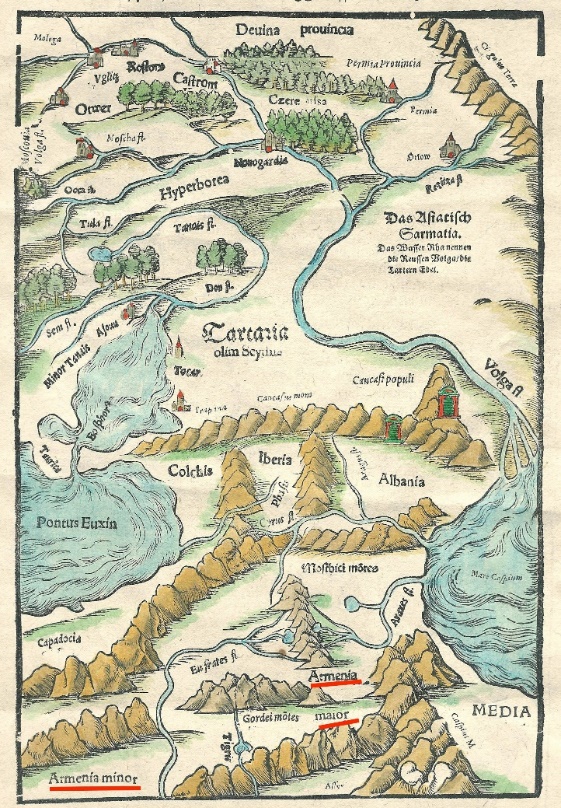
05 – Münster’s original map of 156, entiteld “Asiatica Sarmatia (Asiatic Sarmatia).
B-5. Page 40. Ptolemy’s Persia.
On the lower right of the same page, there is a reproduction of the map of Persia made by Ptolemy in the second century, which was redrawn not by Valgris, as stated in the text by the editor of the atlas, but by Ruscelli, and Vincenzo Valgrisi organised printing of the map in Venice in 1561-2.
At the first glance, map’s relation to Azerbaijan is not noticeable, because there is no name of Azerbaijan on it. The names on the map are Persia, Parthia Media, Mesopotamia and Assyria which are highlighted in red. These names could shown on map 06 also can be seen on the map of figure 07, which is the original version of this map. On image 06, on the left of Persia a question mark has been added in red.
On the original map of figure 07, in place indicated by the question mark on figure 06, there is the toponym ARMENIA PARS, meaning “part of Armenia”. was written in place of this question mark. Perhaps the map was placed in the atlas to show that in the Middle Ages the name Armenia was not among the countries of the region. However, when we look at the actual, unadulterated original copy of the map, one of which is in the British Library, reprinted in Image 07, the issue changes completely and the forgery of the map becomes apparent.
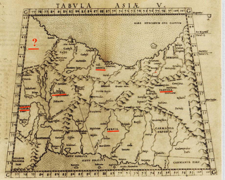
06 – 1561 map by Francesco Ruscelli/ Valgrisi. This is the “processed” map of the atlas.
Image 07 actually clarifies the reason and purpose of the forgery. In this original map, in the upper left corner in place of the question mark, there is also the name of another country, Armenia, indicatred as ARMENIA PARS, meaning “part of Armenia”, as well as the images of several mountains adjacent to Armenia, all of which have been erased from the image 06 appearing in the atlas.
According to the editor, or the order given to him, since the name Azerbaijan is missing from the map, there is no need for the name Armenia to be present on the same map. Therefore, the printed name of Armenia and the Armenian mountains adjacent to it should also be deleted and removed from this page. The mapmaker has done this work flawlessly and skillfully, leaving that territory without any geographical image or name. However, such details are noticeable and discoverable fo the eyes of experienced professional.
An original and unadulterated version of the same map is reprinted in Image 07, and a copy if this maps is also available in Mashtots Matendaran of Yerevan, as well as in the archives of the famous British Library in London, publicly available on the Internet with the following link:
https://aradernyc.com/products/copy-of-ruscelli-girolamo-tabula-asia-vi-venice-c-1562.
Thus, the secret of the map placement is revealed, the fact that in the place of the question mark shown on the image of the map on image 06, the cartographer had indicated ARMENIA PARS, the presence of which was unacceptable for the editor of the atlas. It should be noted that in all the Ptolemaic maps of the time, it is not possible to find one map of this area, where the name of the country Armenia is not present, the Azeri mapmaner achieved this goas by distorting the map and erasing the name Armenia from it.
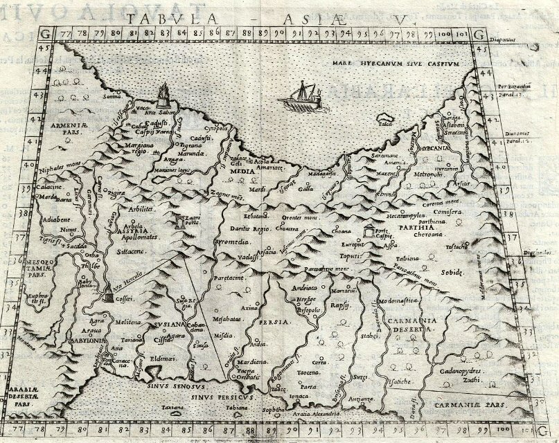
07 – Ruscelli’s map, available at the British Library.
B-6. Atlas page 41 – Map of Persia
On this page is placed the famous Abraham Ortelius’ 1570 Map of Persia, which in Latin is named Persici map of . However, the editor of the book did not realize that it was the name of Persia, so he transcribed the same in the trilingual published text of the atlas as the map od Persici.
The text of the descri[tion relating to the map states that it contains information about Azerbaijan, listing the locations of presumably Azerbaijani cities of Derbend, Shebaran, Baku, Siagi, Ardabil, Tabriz, Zanjan and Shamakhi. It mus tbe said that these cities belong to various countries of the region.
Examining the map reprinted in the atlas, we come to the following conclusion. Nowhere on the map near the Araks and Kura rivers is there any name related to Azerbaijan. Instead, on the western border of Iran, near the name of Lorestan Province, Adilbegian is indicated, highlighted in green, which is the name of Atropaten or Azerbaijan povince of Iran.
Shirvan region, highlighted in blue, is located south of the Kura River, near the cities of Derbend, Shebaran, Baku and Salyan are located in the area north of Shirvan. In the 16th century, this area was under the domination of Persia, where there were several Islamic khanates and the some Armenian principalities.
The name of Azerbaijan is completely missing from the area south of the Caucasus, instead, near the western and northwestern border of Iran, the name of the country ARMENIA is indicated in large letters, underlined in red, which according to Azerbaijani historians, did not exist during those days.
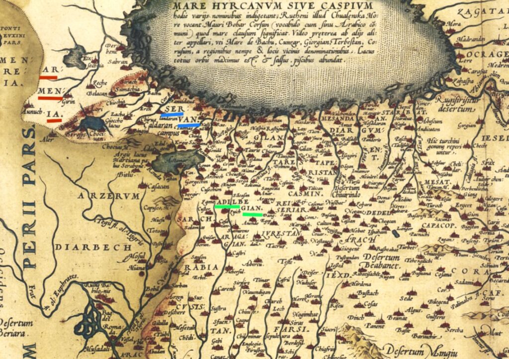
08 – Map of the atlas, with added markings. See text.
B-7 . Atlas page 42 – Parts of Asia
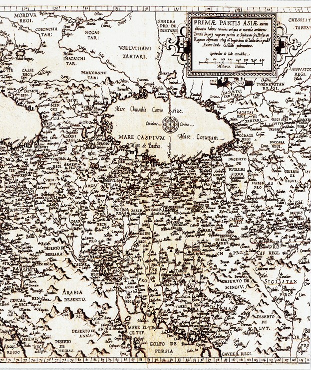
09 – Inferior quality reprinted section of Gastaldi’s 1593 map of Asia, based on de Jode’s original.
10 – For the purpose of quality, a colored and high-quality image of the maps is shown on image 10. This map is available online with the link below.
https://www.raremaps.com/gallery/detail/57018/primae-partis-asiae-accurata-delineatio-de-jode 🡻
This is a colour original of the map in image 09 above, with added markings, as explained on the following page.
The map section of image 10 represents the meeting area of the borders of Persian, Ottoman and Russian empires. Between the Caspian and Black Seas, as well as the area south of them, the name Azerbaijan never appears on the map.
Within the territory of Daghestan, the border of which is marked in red, is the region known as Shirvan/Servan, which is highlighted in blue. This area includes the cities of Baku, Shamakhi and Salyan, both highlighted in green.
There are two names of Armenia on the map. The first one is ARMENIA, the other is TURCOMANIA, which indicates part of Armenia taken over by the Turkish Empire. Both of these are located near the borders of Ottoman Turkey and Pakistan and are highlighted in red.
B-8. Atlas page 43 – Map of the Caspian Sea
This atlas image shows the Caspian Sea, oriented north on the left. The name Azerbaijan is not visible anywhere on the map. Instead, the map’s creator mentions the name Shirvan, which, as mentioned, is a geographical area west of the Caspian Sea.
In Shirvan in the 17th-19th centuries. ruled by several Muslim khans or princes who paid tribute to the Persian king. At the same time, five sovereign Armenian meliks ruled their ancestral territories in Karabakh, who also paid tribute to the Persian king, but ruled autonomously and even had troops. These were the meliks of Dizak, Jraberd, Khachen, Gulistan and Varanda.
B.9 – Map of Asia
Part of Asia can be seen at the top half of page 44 of the atlas. This map was prered by Nillolas de Fer and shows the area of Asia where only the names of the great empires are shown.
11 – Here is the explanations offered regareding the map.
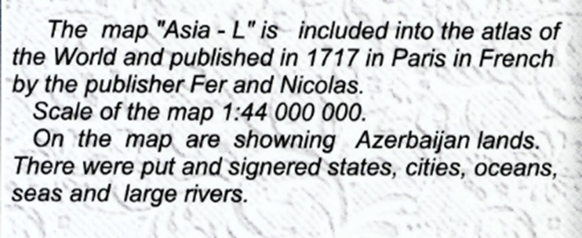
The original text on the map is in French, uses the prefix L before the name, which appears as l’Asie, meaning Asia. The semi-literate translatior has translated it as the map of “Asia L“.
The description says that the map has been published by Nicholas de Fer, who was the Privilaged Royal Cartogrpaher. But the translator of the text has transnated this as “map publisher Fer and Nicholas”.
Furthermore, the last two lines of the text on image 11 make no sense at all.
12 – Excerpt from Map of Asia on page 44 of the atlas.
Study of this detail shows that the map of image 12 does not contain the names of small countries. Thus, for example only the names of Turkey, Muscovy and the Persian Empire and the like are mentioned in the region of Caucasus and the Middle East. The name Azerbaijan is completely absent from the map, and only the region of Shirvan, is shown where there were only Persian khanates and Armenian principalities.
B.10 – Bottom Left of Atlas Page 44 – Map of the Caspian Sea
This map of Atals was prepared by Englishman Herman Moll and published in 1736, based on his maps of 1719-1721. The results was topography of the Caspian Sea region. Here, too, the translator has mentiond erroneously the name of the publisher as Boulz, instead of correct neme of Thomas & John Bowles.
In the region west of the Caspain Sea the name Azerbaijan does not appear, Instead, we can only see the names of Dagestan, Shirvan and Persia.
B.11 – Bottom right of the page 44 of the Atlas – 1823 Map of Persia
This map from the atlas shows the area of Persia during the early 19th century. The attached text contains only the basic information. The cartographer and publisher are the same, namely – Lucas Fielding, of Baltimore.
The explanatory text of the map in image 12 states that all the northern part of the map show Azerbaijan. However, the editor did not notice that insatead of Azerbaijanm the name “IRAK AJEMI” is presnt, here highlighted in red, covering hte northwestern reagion of Persia.
Furthermore, in spite of the declaration of the Azerbaijani experts, who compiled and edited the atlas, the existence of the name Azerbaijan on this map is incorrect to say the least, since it cannot be seen naywhere on the map.
The compiler either had not noticed that the name of the region has been given the toponum of Iraq-Ajemi, or thought that the reader would not notice the word Iraq obscured by being placed between the drawings of the mountains.
12 – Map of Persia in 1823 on page 44 of the atlas. The underlining of the name of Iraq-Ajemi is added to the printed map.
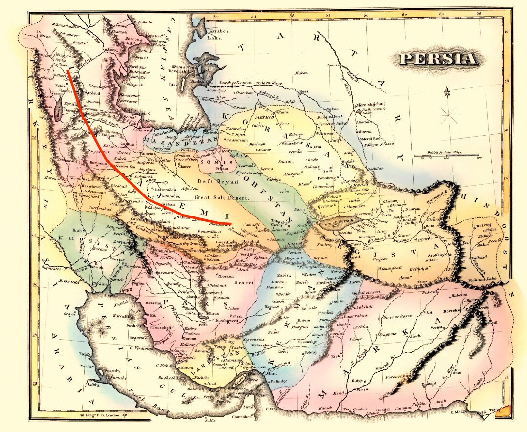
B.13 – page 45. Map of Iran and Turan 45
13 –Reprint of the German map of Iran and Turan, dated 1831, by Petermann, as it appears in the Atals.
The added undelrlining is to emphasize toponyums of the map for the general reader.
Cartouche of the Iran and Turan map in image 13 has been removed from trhwe bottom right of the map and pasted over this section of the map, thus covering the first two letters of the name KASPIESCHES MEER, appearing on the expance of the Caspian Sea.
The explanation offered in the text of the atlas include the following.
The map presents detailed demographic information. …. The unique Azerbaijani names of settlements are indicated in this section.
The editor completely ignores the fact that here the name Azerbaijan is given only to the Persian province of Aderbeidschan located south of Arax River, which is highlighted in green.
The areas surrounding Baku are called Shirvan, highlighted in yellow, which was the medieval name for this territory. Also it is worth to note that the whole of the region was included in TRANSCAUCASIEN-Transcaucasia, highlighted in purple, in particular, in spite of the accompanying text, it lacks any demographic content.
Most importantly, in this map of the Atlas the editor forgotten to order to deletion and removal of the name ARMENIEN-ARMENIA, highlighted in red, which is placed from Lake Vana to Sevan, east of which the name Karabakh is indicated, highlighted in yellow. Thus, the map shows Armenia and Karabakh, but not Azerbaijan. Bearing the name of Azerbaijan south of the Arax Rive there is a Persian state called Aderbishan, whose name in ancient times was Media, which later was renamed Atropaten and during the Arab invasion was evolved into Azerbaijan.
B.14 – Atlas page 46 – Map of the Caucasian isthmus
14 – The Caucasian isthmus, by Gressel printed in Germany, 1856, in the Atlas.
The image was taken from the website below, with underlinings added to assist recognition of the toponyms, shjpn omn the map.The website used was: https://www.davidrumsey.com/luna/servlet/detail/RUMSEY~8~1~21919~690011:Karte-des-Kaukasischen-Isthmus—En
The map in the atlas is the same as the image above, but the one reprinted in the atlas has been cropped in the west, in order to eliminate the letter A of the toponum ARMENIEN, thus rendering the name of Armenia illegible and unrecogniseable. For this reason, the author of this article having located the original map, has reproduced it such manner that it exposes a wider area of the same map of image on page 46 of the atlas, so that the onlooler could see a fuller detail of the map. On this wider reproduction of the same part of the map, the name of Armenia is now fully visible.
The editor has tried cropping and editing the map such, that the name ARMENIA is partly cut off and eliminated from the map.
On this map, as on the map of image 13, Baku and its surroundings are named Shirvan, highlighted in blue. The name Azerbaijan is absent from the map as well.
Instead of Azerbaijan, there are two ancient countries on this map, which are Armenia, highlighted in red, extending from Lake Van to Sevan, and Artsakh–Karabakh, located east of Armenia, extending from Syunik to the confluence of Arax and Kura Rivers, highlighted in yellow.
Those who study the map in detail could also find historical Armenian names of territories and cities, such as Artsakh, Shushi, Airarat, etc. among the place names.
B.15 – Atlas page 47. Ethnographic map and table, 1880
The map in image 15 is from page 47 of the atlas, itself having been taken from the German literature. The table below the map is divided by names of various tribes. These include the Indo-European Mediterranean tribes as well as their Caucasian counterparts. Then come the Uralic and finally the Altaic tribes.
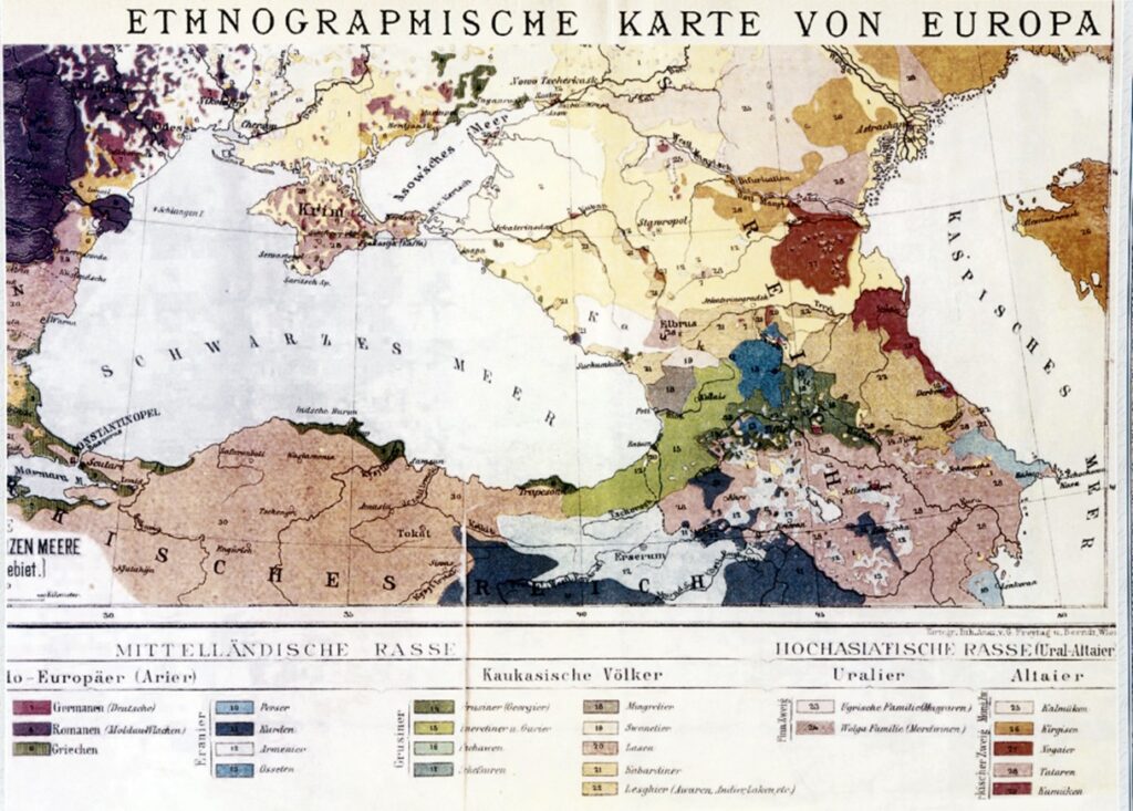
15 – Ethnographic map of Europe on page 47, dated 1880.
In the tables below the map we note the following tribe names and their lanmguage group.
Persians (10), Kurds (11) and Armenians (12) are mentioned among the Indo-European tribes. Caucasians include Georgians (14), Mengrels (18), Lazes (20), Kabardins (21) and Lezgnis (22). The two mountain tribes of Asia are the Hungarian tribes of the Uralic tribe (23) and the Kygiz (26), as well as Tatars (28) of the other mountain tribes – the Altai.
There are no names of Turkish and Azerbaijani tribes, except the Tatars. The editor posted this information probably to present it as a fact, saying that the Armenians were brought to the south and northwest of the Caucasus and Turkey by the Russians. He either ignored or was unaware of the reality that in 1604-6 Shah Abbas of Persia forcibly drove the entire Armenian population of the area, around 300,000 people, from Nakhijevan, Syunik and the Ararat Valley as well as Artsakh, all located north of the Arax River, to Persia, with the aim of making the area uninhabited and unattractive for the Ottoman Empire,with whom they had been at war for a long time.
When the region was occupied by Russa in 1828-29 only one tenth of the forcibly deported Armenians managed to return to their homeland.
At the same time, the map states that the Turkic-speaking Tatars living in the territory of Turkey and all of Azerbaijan are from the Altai mountains, thus being the natives of Central Asia. In other words, thesed tribes are actually the newcomers to the Caucasus and Asia Minor, not the Armenians who were deported from there for 200 years, who, according to the Danish scientific periodical, have lived in their native region for more than eight millennia.
B.16 – Atlas page 49 – Map of aspirations of the newly created Republic of Azerbaijan
In May 1918, when the Republic of Azerbaijan was formed, for the first time, the territory north of the River Arax was given the name Azerbaijan, which was the name of the Iranian province south of the Arax.
The Iranian authorities complained about this new country bearing the name of their provice, bu the western powers were busy in dividing the spoils of the war, which were the Middle East oilfields, never aid any attneion to this problem.
The map of image 16 is taken from the atlas, but in the caption its date is incorrectly given as 1917. This intentional forgery is easy to detect, because the name Azerbaijan-Azerbaijan was first given to its current territory inly in 1918. The present editor has tried to legitimize the name and make the country be older.
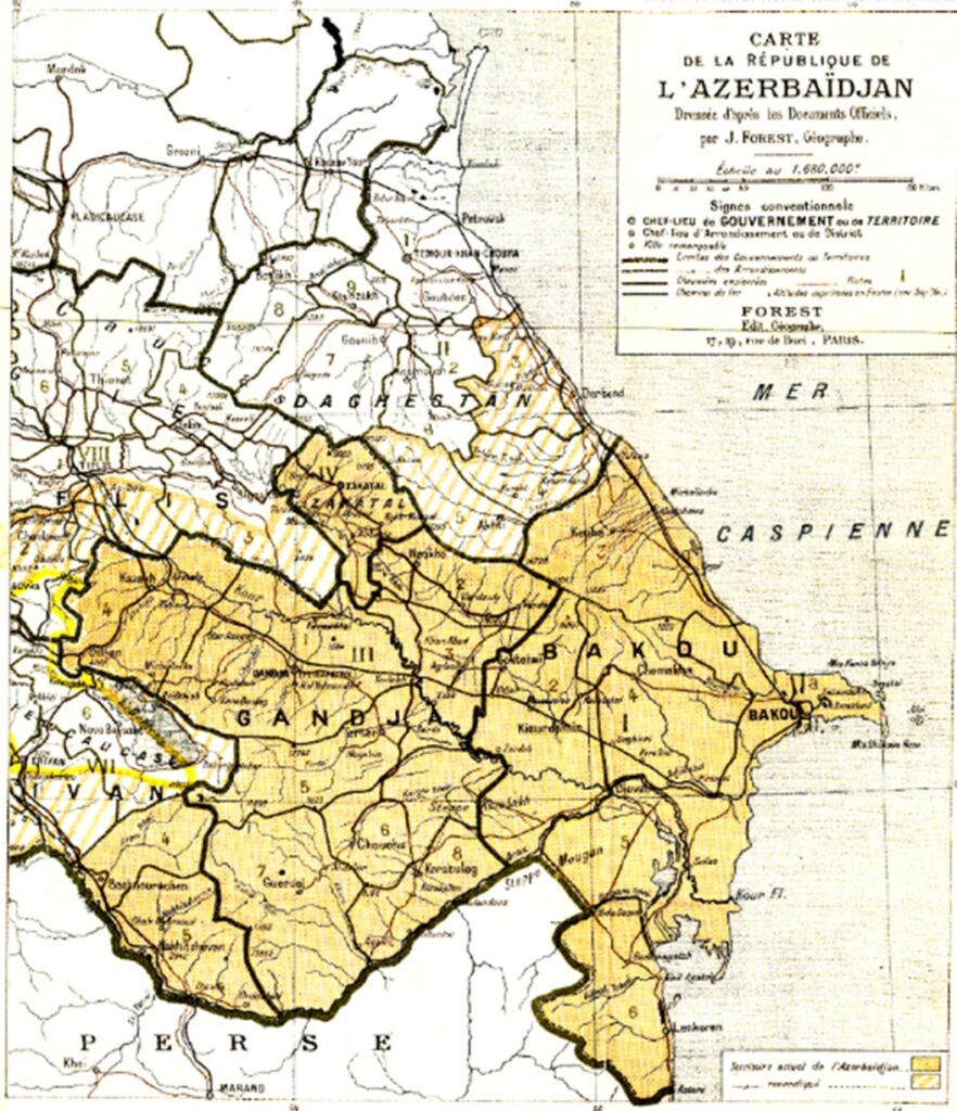
16 –Proposed borders of the First Republic of Azerbaijan presented to the League of Nations for approval in1919.
In fact, the map was prepared for Azerbaijanm’s participants in the Sevres Congress in 1919, as the borders of the Republic of Azerbaijan. According to this maps Azerbaijan has tried to, appropriate areas from Armenia, Georgia and Dagestan marked in light yellow with diagonal lines, which they have added to their land. Of course, that application was rejected, but that did not stop the appetite of the Azerbaijani authorities fraom taking over the neighboring territories.
This can also be seen in the next map, Image 17.
B.17 – Atlas page 58 – Republic of Azerbaijan 1920-1922, actually 1930.
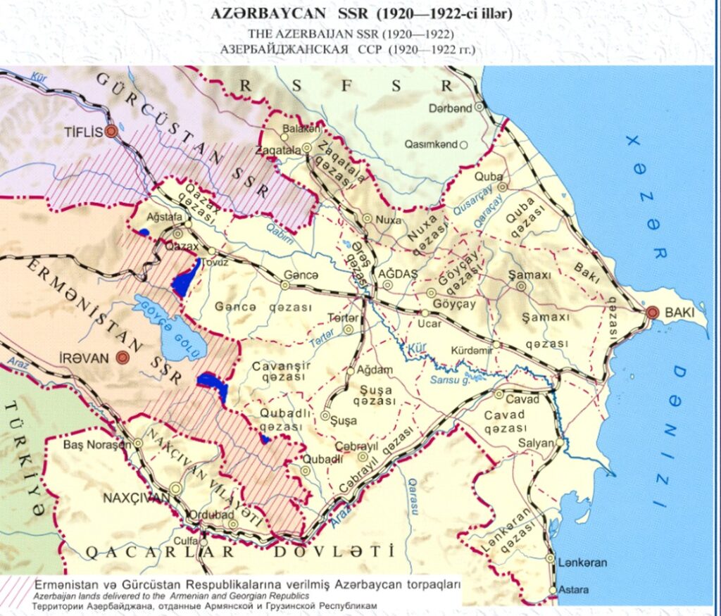
17 – Map of Soviet Azerbaijan, dated 1920-1922, but showing the borders changed only after 1929, which are marked in blue.
As is well known that Azerbaijan was born in 1918, and barely two years later, it was making territorial claims from its neighbors. The first point to be mentioned is that the year shown on the map is incorrect. The map shows Azerbaijani territory as it was in 1929-40, because before 1927-30, the areas marked in blue on the map, belonged to Armenia. These lands were given to Azerbaijan only in 1927 and thereafter. And there are no enclaves in the territory of Armenia, which came into being during 1936-1939.
Yet, Azerbaijan is not satisfied even with these borders and by drawing a diagonal red line on the territories of the neighboring countries, claims ownership, declaring that the territories mentioned are lands captured from Azerbaijan.
It is sufficient to look at the picture of Azerbaijan on the mapprinted in 1926 and reprinted in image 18, to understand what the real borders of Azerbaijan were at the time. On the 1926 map the plots marked in blue on the map 17 here are shown belonging to Armenia as they are located inside the borders of Armenia. This 1926 map could be found in the first great Soviet encyclopedia of 1926.
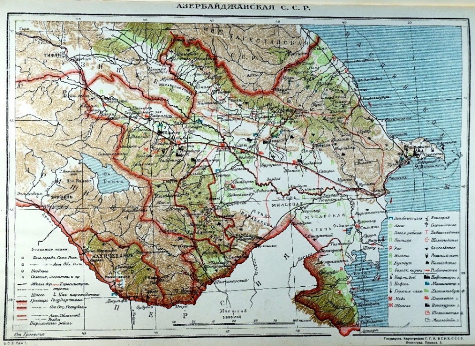
18 – Map of Soviet Azerbaijan, according to the Great Soviet Encyclopedia of 1926. Here there are no enclaves and the territory of Azerbaijan is 84,600 sq. km., not 86,600 sq. km.
Also Karabakh and Armenia hav a common border.
C – Conclusion
In 2014 the National Atlas of Azerbaijan was published aimed first and foremost to represent their country, naturally with maps drawn by their own cartographers. However, trying to penetrate into the depths of history, they tried to prove their claim in order to show that their country is truly an ancient one, with a history of over 2000 years of statehood.
The authors of the atlas strived to provide cartogrpahjic legitimacy to their theory, through medieval western and Islamic maps. It was this error of presenting medieval maps, that their efforts actually proved the reverse. Generally speaking ancient and medieval maps represent a completely different reality. These maps show that until 1918 the territory north of Arax River was never called Azerbaijan, which is clearly visible on all ancient and medieval maps, and even all maps printed prior to 1918.
The maps reprinted in the atlas confirm thath no country called Azerbaijan existed in the south of the Caucasus, while Armenia is present on all of them, even if it does not appear to have an independent state.
The editor of the atlas has tried to actually erase the name of Armenia from several of the the maps reproduced in the atlas, whose only aim was to show that in ancient times Armenia did not exist on the maps, while they were present in the form of Albania, about which see the following paragrpah? However this effort did not escape our attention. In several maps, we have revealed how and why these falsifications were made and furthermore proved that on none of these maps name Azerbaijan, as a country does not exist north of the Arax River, while Armenia, as a country had been shown as Greater Armenia as well as Lesser Armenia.
Making forgeries is already established in Azerbaijani politics. It is noticeable how, in one place, they falsify and present their own prepared maps and borders in any way thatthey chose. Their underlying identity problem is the fact that until today they have not decided which nation and tribe are they heirs of, the Caucasian Albanians or the Oghuz Turkic tribes of Central Asia. When discussing with Europeans, they present themselves as the descendants of the Christian Albanians, and claim ownership to all Christian churches and Monasteries, notwthstanding the fact that the majorityh of these were constructed when mos of the Albanian tribes had accepted Islam. At the same time, whne discussing nationality with Turkey and the Islamic world, they present themselves as Turks, claiming that they are “one nation divided between two countries” with them, for which they blame Russia and Iran.
No matter how much the falsehoods are spread and popularized, in the end the reality and the truth will overcome every barrier and be reborn, and the next generations of Azerbaijanis would demand to know the true facts in order to undrstand their heritage and base.