By Rouben Galichian – Yerevan March 2022
In the aftermath of the withdrawal of Russia from the war and the end of the World War in 1918 and the region which for about 100 years was known as Russian Trans-Caucasian Gubernias or Provinces, were left to their own devices and thus the three Trans-Caucasian Republics were born in 1918.
Two of the countries having had history, reverted to their historic names, Armenia and Georgia. The population of the third country, located on south-western shore of the Caspian Sea, called themselves Turks, Tatars or just Muslims. After independence, the ultra-nationalist Muhammad Amin Rasulzadeh, after consultation with Turkish politicians, took the name of their neighbour, placed south of Arax River, which was the Iranian province of Azerbaijan, and called themselves with the same name. Iran complained against the use of the name of their province by sending an official note, to the Ottoman and Russian Empires to no avail. Meanwhile the western powers were busy dividing the spoils of the war, namely the Middle Eastern oils fields, did not pay any attention to Iran’s complaints.
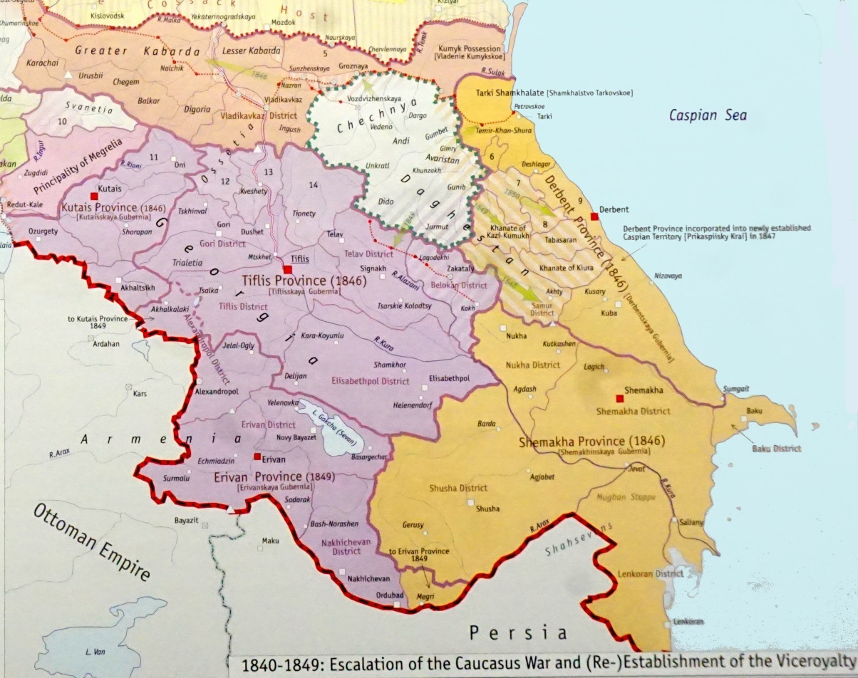
01 – Even in the 19th century in the South Caucasus there was no country or region named Azerbaijan. (Map from A. Tsutsiev, Atlas of Ethno- Political History of the Caucasus, YUP, 2014, Tsutsiyev.
Thus, a country calling itself “Azerbaijan” was born north of the Arax River, who soon began to claim that they have had over 3000 years of history. If we look at tens of thousands of manuscripts and printed maps until 1918, we can see no country named Azerbaijan could be found north of the Arax River. The exception is one map inside an Atlas published by SDUK, in 1844 in London, where the cartographer mistakenly has written the name Azerbaijan between Armenia and the Georgia, which was corrected in the remaining maps of the same atlas. As seen on the map 01, which shows south of the Caucasus after the conquest of Russia in 1828, following over 200 years of Persian suzerainty. The map indicates the Russian administrative divisions of the region during 1844, when it was divided into the Provinces of Erivan, Shemakha, Tiflis and Derbend of the Tsarist Russia, with no mention of the name “Azerbaijan”.
As “prove” their lengthy existence, whenever they possibly can, Azerbaijan has been waving this unique map mentioned above, not realizing that one erroneously entitled map cannot be proof of their 3000 year of existence, as it is only dated 1844.
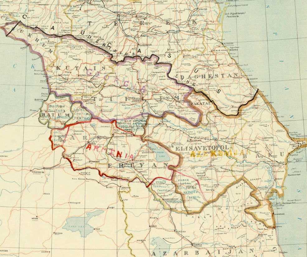
02 – On this map of the region published in 1919, the Name Azerbaijan has been printed as the Iranian province, south of the Arax River; while the names of the new republics created in 1918 are added in reddish ink.
This newly born Azerbaijan tried to ascertain itself and even laid claim to the majority of the territories south of the Caucasus, which caused disputes and hostilities with Independent Armenia and Georgia. Majority Armenian populated region of Nagorno Karabakh was claimed by the Azeris, so were Nackhijevan and the Armenian populated “eastern Syuniq”. The dispute regarding these regions continued until Azerbaijan was taken over by the communist Russia (28 April, 1920) and Armenia accepted the Soviet rule on 29 November, 1920.
The day after Armenia accepted the Soviet rule, the Azeri government announced that Nakhijevan and Mountainous Karabakh (which included the regions of Kalbajar, Lachin and Easter Syuniq) were to become part of Soviet Armenia and thus the disputes between the republics would be resolved. Therefore when Armenia was handed over to Soviet Russia in December 1920, its territory consisted of the regions shown on the map below, which covered and area of about 43,000 Square kilometers.
Later, by the treaties of Moscow and Kars, the Armenian regions of Borjalu, Mt Ararat, Kars including the ruins of Ani were handed over to the Ottoman Turkey by Soviet Russia. This was done in order to entice Ataturk to join the communist camp, which later backfired.
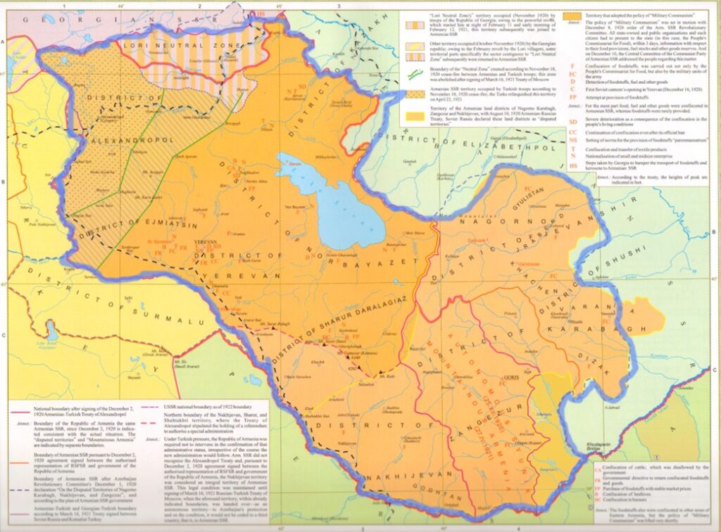
03 – The territory handed over to the Red Army in December 1920.
Some 7 months afterwards, in early July 1921 Stain visited Baku and at first approving the announcements of the Azeri government regarding Nakhijevan and Mountainous Karabakh, however, after a closed-door session, the following day the Caucasian Bureau announced that these two regions will be placed in Azerbaijani control. See Map 04.

04 – Region framed by green are those given to Azerbaijan on 5 July, 1921, as decided by Stalin.
AS can be seen on the maps , the region named Mountainous Karabakh included all of Kallbajar (Armenian Karvajar), Lachin (Armenian Kashatagh) and eastern Syuniq.
By 1921 the Republic of Azerbaijan was established in the South Caucasus and in spite of the territorial advantages given to them by the Communist authorities continued their quest of trying to appropriate as much territory from Armenia as possible.
Now South Caucasus had a new republic, which named itself Azerbaijan. In order to ascertain themselves as an old country, the newly born country needed to establish their ancestry as well as history and culture.
According to Stalin’s announcement, each republic of the Soviet Union should have its own culture, language and history. Yet many of the republics such as all Central Asian ones were non-existent before the USSR and all of them were founded between 1923 and 1936. Azerbaijan was the exception, which was founded a few years earlier – in 1918, but in spite of the fact that the country had called itself Azerbaijan, its population; except the considerable number of minorities, called themselves Turks, Tatars or simply Muslims; while the Soviet authorities called them Turks or Tatars. This continued until 1936, when under the pressure of the central government the population of the country was renamed “Azerbaijani”.
Regarding their ancient ancestry the authorities of the newly created republic have chosen a few paths and means, as described below.
- They sometimes claim that they are the heirs of the Caucasian Albanians, which cannot be, as there were no Albanian people in the regions. It is well known that according to Strabo, in the region named Albania there lived 26 different tribes who each had their own language, and it was only the region that was called Albania, not the people who lived there. As stated, they each had their own individual tribal name and language, such as Lezgi, Avar, Tsakhur, Talish, Udi, Ingiloy etc.
- They also claim that they are of the same heritage as Iranian Azerbaijanis. Genetic search of the Iranian Azerbaijanis has proven that they are of Indo-European stock and until the 15-16th centuries spoke with couple of variants of the Iranian Pahlavi language. Iranian scholar Ahmad Kasravi states that as the people of the Iranian Azerbaijan did not have a written language, during the 15-16th centuries they adopted the language of the ruling Turkic tribes, who arriving from Central Asia had conquered these lands and spoke with various Turkic dialects. He also adds that in the same region there also lived many Armenians, who kept their language and identity, because they had their own script and written language.
- The third alternative is that depending on expediency, the Azerbaijani historians also state that they are of Turkish stock and that they, as well as the peoples of Turkey, are of the same Oghuz stock who have been divided between the two countries of Turkey and Azerbaijan b y the Iranian and Russian empires. About this claim anon.
- In February of 2022 there was an official announcement by the officials of Azerbaijan and Turkey that the peoples of these countries are of the same, that is of the Oghuz Turkic ancestry, thus once and for all refuting the previously and even later claimed Albanian heritage of the peoples of the Republic.
For a newly born country to have to its own, individual culture there was no other way but to appropriate the existing historic monuments and claim them to be their own, while calling the actual builders of these monuments “newcomers” to the region, which has been carefully implemented. In order to lay claim and appropriate all religious and cultural monuments the authorities of the Republic of Azerbaijan used the following tactics:
- Begin with their cultural falsification by first claiming them to be their own. Meanwhile claiming that the Armenian ere newcomers to the South Caucasus, who were brought from Iran and Turkey by the Russians. This could not be proven because of the existence of multitude of reports and documents dating from the early Middle Ages, written by Islamic and European travellers confirm the existence of the indigenous Armenian population in the South Caucasus.
- The next step was to claim that those Christian monuments were built by the Caucasian Albanians, who, as mentioned above did not exist as peoples and even if they did, majority had converted to Christianity during the late fourth century but nearly all converted to Islam between the 9th and 13th centuries. The question arises “how could a Muslim population living under the Muslim leadership build the plethora of Christian monasteries, churches and monuments during the 13th to 19th centuries? In a Muslim country the building of even a Christian chapel needed a special permission from the religious and secular Muslim leaders of the particular region, which was a rarity.
- When Azerbaijani authorities discussed their ancestry with representatives of the Christian nations, they claimed to have Albanian Christians as their ancestors, who had later converted to Islam. At the same time when discussing it with Turkey and Muslim nations, their claimed to have Turkic Oghuz ancestry. As mentioned in the Par. 4 above, their latest official announcement states that they have Turkic ancestry; therefore, whoever they were, they could not claim to be the heirs of the Albanians! By the same token, the Christian monuments have no relation to the Oghuz Turks of Azerbaijan!
- Another weapon in Azerbaijani arsenal, aimed at the removal of names of the Armenians from their region was that; if the ownership of a monument could not be attributed to the Albanians, these should be destroyed.
Following the above maxim, between the years of 1998 and 2005 the Medieval Armenian cemetery of Julfa, located north of the Arax River in Nakhijevan, where over 5000 Cross Stones (Khachkars) most with Armenian inscriptions stood for six centuries, were first toppled over, then broken into pieces using pneumatic drills, and finally, with the help of the Azerbaijani armed forces smashed into pieces> They were then carried away for use as construction material or were simply dumped into the Arax River, in full view of the observers from the Iranian side of the river.
The destruction of thousands of Khachkars was done in spite of the assurances by Azeri Ambassador in Germany – Huseynaga Sadighov, as well as the Azeri religious leader – Allahshukur Pasha Zadeh, both claiming that the cemetery is not Armenian, but Albanian, furthermore that these tombstones are protected (see R. Galichian, The Invention of History, 2010.)
If this really is the truth, then why did the Azerbaijani authorities destroy monuments of their own heritage?
- At the same time, Azerbaijani authorities arranged the complete eradication of ALL Armenian monument found in Nakhijevan, thus completely destroying hundreds of monasteries, churches, chapels a and monuments, the traces of which have been completely erased! See R. Galichian, The Invention of History, 2010.
During a lecture in the University of Baku the famous Russian orientalist V. Barthold stated that “The establishment of Azerbaijan north of the Arax River was aimed at the appropriation of the Iranian Province of Azerbaijan”, whose name they had already appropriated (see V. Barthold, Studies in the History of the Caucasus, Moscow, 1963.) After the end of the World War II, during which Iran was occupied by the USA, Great Britain and the USSR, the Azeris established a so called “Democratic Azerbaijan” in the north-west of Iran, inside the Soviet controlled region. At the end of the war the USSR tried to annex the region with Soviet Azerbaijan, it, however failed due to the Iranian diplomacy and intervention of the Iranian forces.
In mid-July 1923 Azerbaijan announced the creation of a new province entitled Red Kurdistan located between Azerbaijan proper and Armenia, where all the Kurds living in the republic would be centralized.
As Kurds were sheep herders and the allotted terrain was mainly mountainous, therefore the Trans-Caucasian Federation made various decisions to hand over Armenian grazing lands and fields to Azerbaijan, in order to secure the livelihood of the Kurds.
Most of these land transfers were done without even the knowledge of the local population. Some villages send letters of complaint but to no avail. The Trans-Caucasian Federation, who was in control, invariably made decisions in favour of Azerbaijan.

05 – Map of planned Red Kurdistan
During the years of 1923 to 1929 over 1500 square kilometers of Armenian pastures, fields and forests were handed to Soviet Azerbaijan, under the pretext of providing the Kurds with sufficient pasture and living areas. On the following map 06, the blue regions are those that were allocated to, variously appropriated by Azerbaijan during the years of 1925-1940.
However, during the years to follow, the plan for the creation of the region for the Kurds was annulled and the Kurdish province was not established. Notwithstanding the above, and that the reason and excuse of “allotment of land for the Kurdish shepherds” was no more applicable, and the previous reasoning of transfer of lands was now obsolete, the Azerbaijani authorities never returned the subject Armenian lands to the original owners, that is Armenia.
During the same period some pockets of Armenian land were for no apparent reason given to Azerbaijan, which were called “Azerbaijani enclaves inside Armenia”. An enclave is a territory belonging to another country wholly placed inside the territory of the other.
The only loosely offered explanation is that these regions of the Armenian enclaves were populated by Azeri villagers, therefore it was best for them to be under Azeri rule. The counter argument is that there were many other Azeri populated villages inside Armenia before the demise of the USSR, which were not enclaves. Furthermore and by the same argument, the whole region of Nagorno Karabakh inside Azerbaijan was 85% Armenian populated, this region should be given the status of Armenian enclave inside Azerbaijan?
The placement of the Armenian enclaves inside Azerbaijan is also a matter to be considered. It can be seen that this Armenian enclave in 1920s was wholly part of Armenia, including its surrounding areas and access corridor. Azerbaijan first appropriated all the lands around Artsvashen, then offered it as an Armenian enclave. See map 06.
The two Azeri enclaves in the north of Armenia (Askipara and Barkhudarlu) were established in the mid-1930s, but the third one in south, was established in 1939-40. The placement of Azeri enclaves is such that two of them are placed on the Armenian highways and thus could control the traffic inside Armenia, which is of the utmost strategic importance. How could this be explained and why would the Soviet authorities give the control of Armenian highways to Azerbaijan?
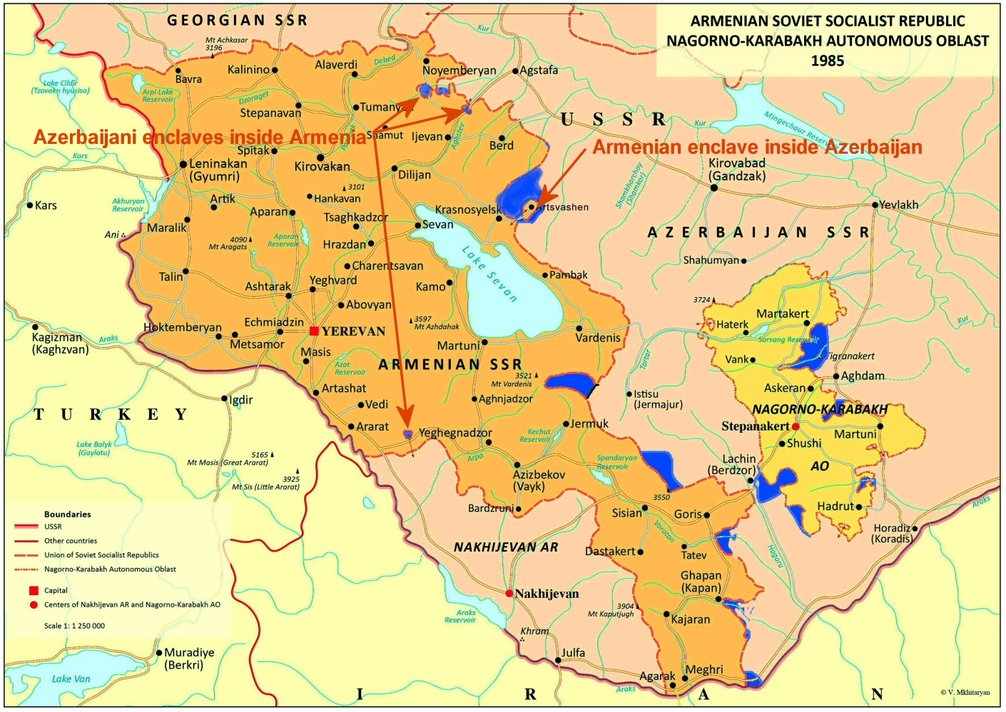
06 – The map of Armenia and Karabakh, where the regions in blue were appropriated by Azerbaijan between the decades of 1920s and 1930.
© Rouben Galichian – 2018