ARMENIA IN THE MAPS OF AL-ISTAKHRĪ
Abu Ishāq Ibrāhim bin Muhammad al-Farsī al-Istakhrī known as al-Istakhrī (died 957 CE) was one of the most important Persian (known as IslamIc) geographers. Al-Istakhrī is known primarily for his book of geography entitled Kitab al-Masālikva al-Mamālik (Book of Routes and Realms), various versions of which contain 19 to 21 maps, including a world map and maps of the Muslim lands, together with chapters of related text providing descriptive information about each map, province and people living in them. In all the versions there is a chapter on “Armenia, Arān and Azerbaijān”, where the relative positions of these three lands, names of their cities are listed. Thirty-four of al-Istakhrī’s manuscript copies have survived, most of them with many maps of which the oldest dates from 1173 CE.[1]
Istakhri was one of the most important geographers of the Balkhi school, which was the dominating cartogrpahic school of the Islamic world of the time. Other geographers of the Balkhi school are Birouni, Ibn Hawqal, al-Masoudi, al-Muqaddasi and others.
Islamic books of geography and travel most contain world maps, and but when it comes to provinces and regions and their maps are remarkably similar, generally showing the Muslim world only. The tenth century Arab traveler and geographer al-Muqaddasī (945 – c.1000 CE) in his geographical treatise entitled Ahsan al Taghāsim fi Ma’rifat al-Aqālim, (The best divisions for the knowledge of the Provinces), written around 985 CE states:
“We have written here only about the realm of Islam; we do not bother ourselves with the countries of unbelievers and we see no use describing them. Of course we mention those areas among them where Muslims live.
However, in the map depicting region of the South Caucasus an exception has always been made. Armenia being an important neighbouring country and trading region, where some Muslims also lived, is the only non-Muslim country shown in the Balkhi school maps of the provinces and countries.
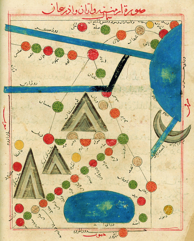
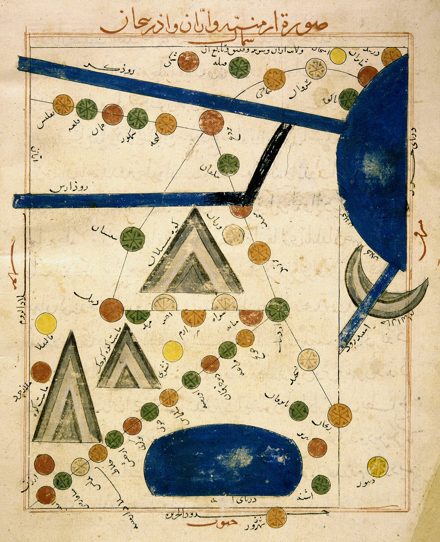
The attached images are one of al-Istakhrī’s maps entitled Surat Armīniya va Arrān va Adherbeijān taken from yet a copy of his manuscript of Kitāb-ul-Masālik va al-Mamālik, the original of which was written in 950 CE. The first copy is kept in the Museum of Iran Bastan in Tehran and is a Persian translation of the Arabic manuscript, dating from 1325 CE. The second one being a copy of the same map from a manuscript kept in the Bodleian Library of Oxford. Contrary to other maps of his book, where the maps generally have south at the top, this map is oriented with north at the top.
In the first map the cities are coloured in a variety of colours and the city of Nashwi (Nakhijevan) is shown at the foot of the Small Ararat, where Dabīl used to be, and Dabīl has been elevated to near the summit of Small Ararat, here named Māsst (in Armenian – Māssis). Here the differences created by the copier of the map are very clear. The scribe may have used a previous map as a source, but has also used his imagination in presentation of various features of the map. The error in naming Ararat as Māsst instead of Māssis, is due to the scribe’s unfamiliarity with the name. The misplacement of the dots in the Arabic and Persian scripts has changed the letter from “s” to “t”, thus renaming this mountain.
Someone has later corrected the course of the river Arax to join the Kura prior to reaching the Caspian, whereas in other old maps these two rivers are shown each flowing into the Caspian separately. The correction has been made subsequent to the completion of the map and is drawn in different ink.
On the western shores of the Caspian we see Bāb-ul-Abwāb (Derbend, orange), Shābarān (red), Bāku (green), with Shirwān(grey), Shamākhi (orange) and Shaki (red) to the north of the river Kura. To the south of it we note Tiflis (orange),Qal’ah (green), Khūnān (red), Shamkur (green), Jenzeh (orange, misspelled in the map), Bardahe (Barda – red) and Bylghān (green), all shown in the territory of Arrān (Caucasian Albania). The river Arax runds along the southern border of Arran, between Arrān and Adharbeijān.
Further down, on the southern shores of the river Aras is the territory of Azerbaijan. South of Deilam Mountains (the Alborz range) there is another river flowing through Gilān (or Tabarestān) province of Iran into the Caspian Sea. Its name is given as Sefid Rūd, White River.
To the South of the river Aras (or Arax), at the western edge of the map we note the city of Kāliklā (in yellow, the old Armenian city of Karin, now Erzrum) and Malāzgerd (red). Next to Malāzgerd are the twin mountain peaks of Ararat (see paragraph two above). To the east of these lies the Armenian city of Nakhijevān, here named Nashvi (yellow). Between the twin peaks of the Ararat, the old Armenian capital Dabīl (Dvin – red) is also shown. The road leading from Ardebil south-westward is lined with the cities of Khunj (orange), Marāghe (green), Dākherghān (red), Urmiya (green), Salmās (orange) and Khoy (green). The road then carries on to the territory of Armenia and passes through Berkrī (red), Arjesh (green),Khlāt (orange), Bitlīs (grey), Miāfārghin[2] (green) and Āmad[ia][3] (red). The city of Arzan (red, just below Ararat) is located near the end of this road. This province is indicated with the inverted and slanting legend Bilād Armīniya (Armenia). The large circular lake, half of which is shown on the map, is entitled Daryāye Armīniya, the Armenian Sea (Lake Van).
The large mountain in the centre of the map located in the province of Azerbaijan is Kuh-e-Sabalān (Mount Sabalān). On the road emanating from southeast of this mountain, from the right we see the cities of Ardabīl (green circle) on the crossroads, Miāneh (red semicircle), Sarāb (grey), Eram (orange), Ahar (grey) and Marand (green). Other cities of Azerbaijan shown on the road going south-east from Ardabil include Meymand (grey) and Zanjan (orange), with the cities of Dājermān (green), Tabriz (red), Ashneh (Oshnaviyeh – green) and Dināwar (yellow) shown away from the main road. The city of Shahrazūr (orange) is outside the map frame, on the border of Aljazeerah (Mesopotamia).
Once again here we see the roads interconnecting the main cities of the region, making this a regional road map.
IMap 1 – Istakhri’s map entitled The Map of Armenian, Aran and Azerbaijan, from his book entitled Kitab ul-Mamālikva al-Masālik. MS dating from the 950 CE. Iran Bastan Museum, Tehran.Ref. MS.3515, f. 75b.Copy dated 1325 CE
The second map is another version of the map of the same region, where the layout and the toponyms are very much similar.
The maps clearly indicates that the region contains only three countries, Aran, Azerbaijan and Armenia, confirming that countries of Aran (Caucasian Albania) and Azerbaijan are two distinct and separate lands separated by the river Arax, while the text specifies the difference of the ethnicity and language of their population. Thus, the Islamic maps of the ninth and tenth come to prove that the claims of the authorities and specialists of the Republic of Azerbaijan, concerning the antiquity of their country are mere fantasies and that their country was in fact established in 1918, borrowing its name from the Iranian province of the across the river.
 Map 1 – Istakhri’s map entitled The Map of Armenian, Aran and Azerbaijan, from his book entitled Kitab ul-Mamālik va al-Masālik. MS dating from the 950 CE. Iran Bastan Museum, Tehran.Ref. MS.3515, f. 75b.Copy dated 1325 CE
The second map is another version of the map of the same region, where the layout and the toponyms are very much similar.
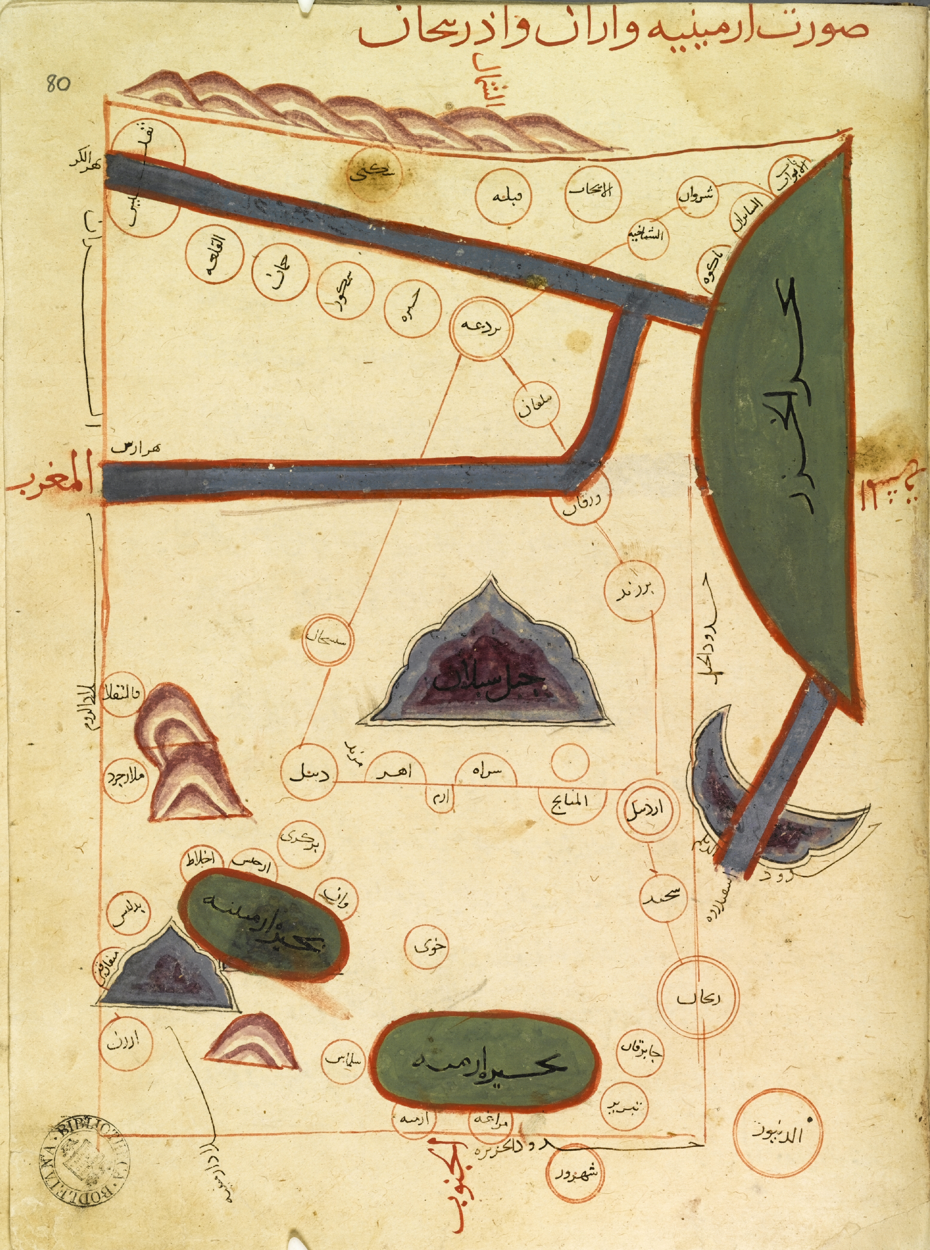
Map 2 – Istakhri’s map entitled The Map of Armenian, Aran and Azerbaijan, from his book entitled Kitab ul-Mamālikva al-Masālik. MS dating from the 950 CE. Bodleian Library MS Oussley 373, f.80a.
© Rouben Galichian, 2011
[1] Harley and Woodward, History of Cartography, Vol. 2, Chicago: Chicago University Press, 1992, p.130.
[2] The old city of Tigranakert (near Silvan), which was one of the capitals of Armenia, built by King Tigran the Second, during 70’s BCE. See Hacopian., Melik-Bakhshian et al. Toponyms of Armenia and the Neighbouring Countries, Vol. 1, Yerevan, 1991, 678, 818, Vol. 5, Yerevan, 2001, p.92
[3] Amadia (in Armenian- Amid) was a castellated Armenian town today situated in the territory of Eastern Turkey.