
When an Armenian is asked how he or she would describe their country to a non- Armenian, most would reply “we were the first country to accept Christianity as the state religion in the year 301”. This is all true but would it carry any weight if you were to say this to a Muslim, Buddhist, or even an atheist?
Would it not be better to claim truthfully that Armenia was one the three countries that appear on the oldest World Map drawn on a clay tablet in Babylon some 2600 years ago?
This article will help the reader in gaining some basic awareness about how have the non-Armenian geographers regarded the Armenians and the country of Armenia over the past two millennia. The article also contains some basic information about Armenian cartography.
* * *
The Armenian people have lived continuously in the general area of the Armenian Highlands and the South Caucasus for over 2600 years. This land has been called by various names such as the Land of Urartu, Land of Ararat, Armenia, Arminiya, Hayastan (the Armenian name of their homeland) and some medieval cartographers even called Western Armenia as “Turcomania”. The name “Armenia” could be observed on maps of the various historic periods as well as in the historical and geographical works from the ancient to the most recent times.
Armenia has appeared in all the maps of the area of Near and Middle East, sometimes as an independent state and at other times as a country divided between its neighbouring empires. In one form or other, it invariably does appear in the texts and the maps of the ancient Greeks and the Romans as well as in Islamic and Western literature and maps. It must be noted that during the earlier periods and even up to the fourteenth and fifteenth centuries lands were mainly called by the names of their autochthonous people. This is particularly evident in the case of the Armenian people who lost their kingdom and independence during the last decade of the fourteenth century, yet for the following 530 years all the lands where they lived (including Armenian Highlands in eastern Turkey, Russia and Iran) almost all maps were inscribed with the name “Armenia”. The name appeared on the general area where the Armenian homeland, where they had lived for centuries. This naming continued until 1920-25, when due to the brutal ethnic cleansing realised by the Genocide of 1915-1923 perpetrated by the Ottoman Turkey, the area became devoid of its native Armenian population and the name ceased to appear on the maps.
Despite being landlocked, Armenia even appears on portolan marine charts, which were produced for navigational purposes and generally covered coastal countries and towns only. This will be discussed later.
The Early Times
The oldest known map of the world, a Babylonian clay tablet dating from the sixth century BCE, depicts the world as a disc floating in the bitter seas with Babylon at its centre, surrounded by Assyria, (city of) Harran and Armenia (see end note 1). On this tablet the river Euphrates is shown flowing down from the Armenian mountains passing through Babylon (Iraq) and eventually reaching the Persian Gulf.
The Greek historian Herodotus, who lived around 489–425 BCE, was a keen geographer, also traveled to Armenia. According to him, in about 500 BCE, Aristagoras of Miletus exhibited a map in Sparta, which he had made on an iron plate. The map is said to have shown the territories of Lydia, Phrygia, Ionia, Cilicia, the island of Cyprus, Armenia and the city of Susa, the seat of the king of Persia.
The name of Armenia appears in many of the Greco-Roman geographical and historical texts and books. The Greek philosopher and geographer Eratosthenes (c. 276–194 BCE) accepting the existing theory of the earth being spherical, suggested that it was the centre of the universe and all the celestial bodies revolved daily around it. His world map includes the country of Armenia. (See Fig. 1)
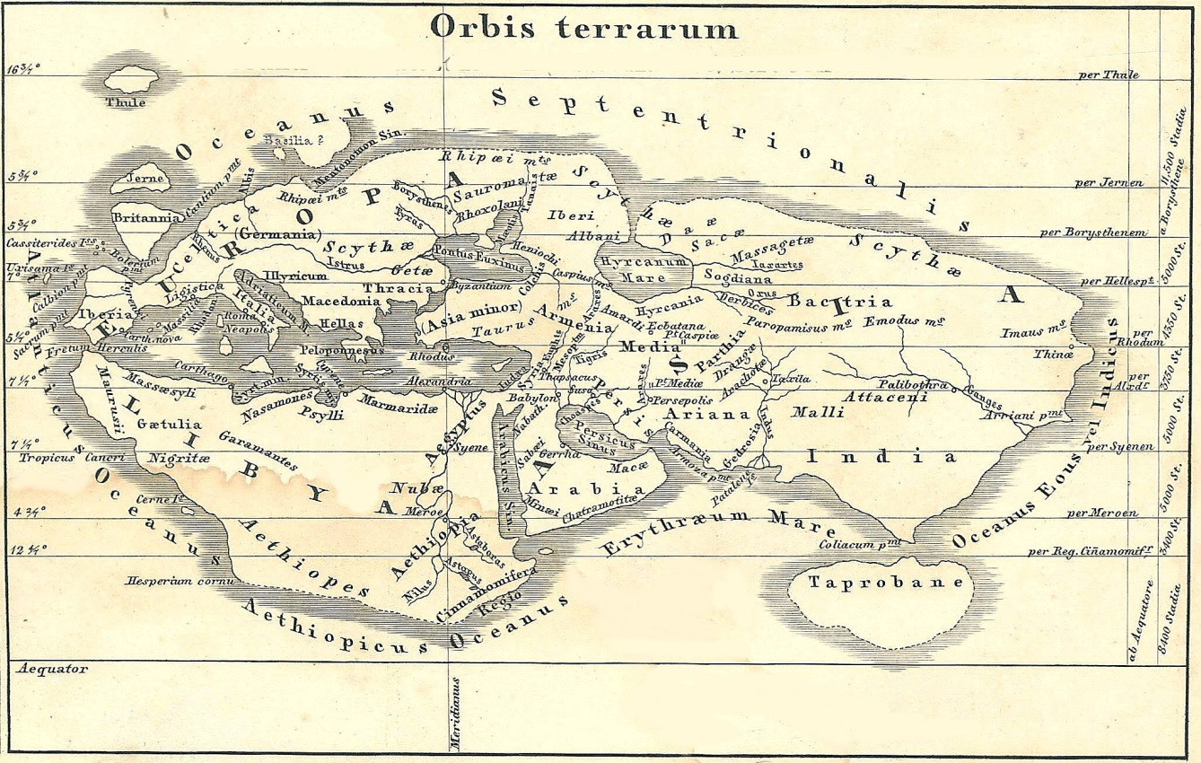
Fig. 1 – The World Map of Eratosthenes, reconstructed by von Spruner in 1855 is dated around the third century BCE. The three continents are shown named Europe, Asia and Libya. Armenia is placed in the middle of the world, just south of the Caspian and Black Seas.
Strabo (c. 63 BC – 24 CE) was one of the giants of geography. He was a seasoned traveler and also worked in the library of Alexandria. The library could boast almost all the known works on the subjects of medicine, astronomy, science, literature and philosophy, to which Strabo had easy access. His Geogrpahy volumes were completed in the second decade of our era, containing almost everything known about geography and cartography during his time. Strabo’s description of Armenia occupies many pages of description of the land and its people and includes over 60 references to this country.
Some world-famous cartographers have prepared maps of the world according to the descriptions provided by Strabo, which invariably include Armenia, located north of Mesopotamia and south of the Caucasus.
Claudius Ptolemaeus of Alexandria, or Ptolemy as he is generally known (c. 90-168 CE) was the most important figure in geography and cartography of the old world, whose books and maps were used extensively well into the sixteenth (see end note 2).
His most important work is the eight-volume book Geographia, the text of which has reached us in its entirety. The first volume of his work talks about geography and ways and methods to be utilized in observing and calculating locations, some of which are still in use today. Most of the volumes are detailed descriptions of some 8000 locations of the then known world, divided into various regions and countries. The approximate boundaries of every country is described, giving details of the neighbouring countries and the sources and destinations of various rivers, as well as lakes and mountains belonging to each country. (See Fig. 2)
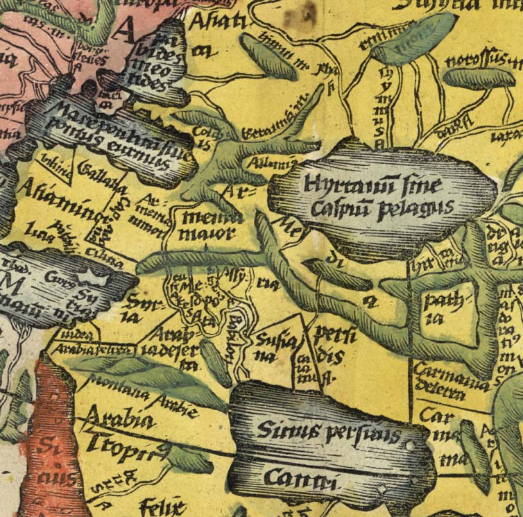 Fig. 2 – Detail form the World Map of Ptolemy, dating from the second century, showing the area surrounded by the Black Sea, the Caspian Sea, West Mediterranean and the Persian Gulf. Two Armenias are shown. Armenia Maior placed south of the Caucasus and Caucasian Albania, west of Media, north of Mesopotamia and east of Armenia Minor. The map is from Ptolemy’s Geographia, printed in 1531.
The chapter concerning Armenia (Book V) is in two parts. Lesser Armenia (Armenia Minor), shown on the map entitled “Tabula I of Asia”, lists 79 names of towns and cities, and Greater Armenia (Armenia Maior), which is shown on the map entitled “Tabula III of Asia” lists 85 town and city names. The important towns of Greater Armenia are stated to be Artaxata (Artashat), Harmavira (Armavir), Tigranocerta (Tigranakert), Arsamosata (Arshamashat) and Thospia (Van). Those of Lesser Armenia are Coma, Melitana (Malatia), Nicopolis and Satala. (See Fig. 3 ).
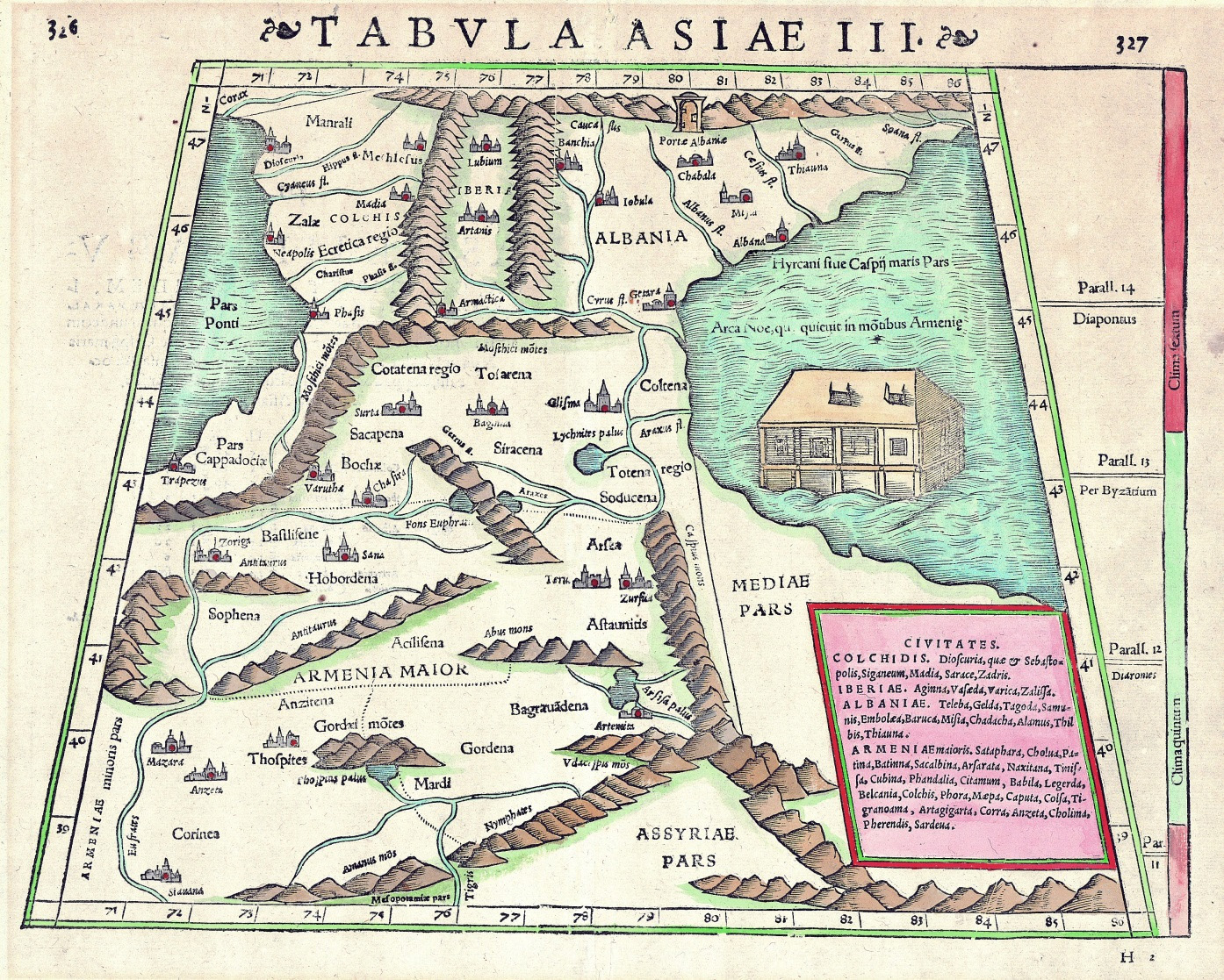 Fig. 3 – Ptolemy’s “Third Map of Asia” from the Geographia, printed in 1531. This map shows Armenia Maior, Colchis (Abkhazia), Iberia (Kartli – part of present-day Georgia) and [Caucasian] Albania, covering the general area of present-day Republic of Azerbaijan.
In his text Ptolemy often refers to particular maps and discusses how to draw and update them with all new information received from travelers and other sources. He divided the habitable world into three continents, Europe, Africa and Asia, while the maps accompanying the book were grouped as below:
- Map of the World
- Europe, in ten regional maps
- Africa, in four regional maps
- Asia, in twelve regional maps.
The name of Armenia appears in five of the above set of 27 maps. Ptolemaic maps are simple and lack the elaborate cartouches common in those of the sixteenth to eighteenth centuries. Some fifteenth- and sixteenth-century copies of Ptolemaic maps are hand coloured and some others have reached us uncoloured. A few have been printed on vellum.
Roman and Christian Cartography and the Middle Ages
As expected, the name of Armenia is always present on the maps of the Christian era since it was the first and only Christian country east of Asia Minor – Anatolia. In Christian cartography Armenia is frequently identified with Mount Ararat and Noah’s Arc, as per the biblical account of the Flood. In some maps the Garden of Eden or Terrestrial Paradise is shown inside or adjacent to Armenia.
The oldest Roman map is the ‘Peutinger Map’, the archetype of which dates from the middle of the first century CE. This is a road map is some 34 cm wide and 6.4 metres long, a fifth-century copy of which has survived. The map shows various routes radiating from Rome to the four corners of the empire, including Armenia, where the names of Artashat, Bagrewan (misspelled Raugona), Vostan (Van) and Tigranakert are recognizable.
With the coming of Christianity and religious fervour, especially under the influence of the Biblical theory of the Creation, the western science of cartography suffered immensely and there was no advance at all in the field from the second to the fifteenth century CE, except for cosmetic modifications and representations. In the western Christian world during this period all the old theories and scientific works were pushed aside and were replaced with new ‘facts’ based on the teachings of the scriptures.
Since the sixth century the spherical earth was replaced by a flat disc-shaped one, divided into three continents and surrounded by the oceans. This was adopted by Isidore of Seville (c. 560–636), who included the T-O map of the world (see below) in his Etymologiae. This type of maps appeared in hundreds of manuscripts and, with some modifications, formed the backbone of the Christian cartography for almost 1000 years.
The maps developed according to this doctrine were simple ones called T-O maps, which came into being in the Middle Ages. These maps, if they could be called that, showed the earth in the shape of a circle, or letter O, with the letter T inserted into it, in order to divide it into three known continents, hence the name, which could also be short for ‘Orbis Terrarum’. In these maps east was invariably at the top, where Paradise was also located. The vertical line forming the stem of the letter T represented the Mediterranean Sea and the two parts of the cross bar were the Rivers Nile and Don, thus dividing the world into the three known continents, the largest being Asia and the smaller two Europe and Africa. Many of these maps have survived in various manuscripts and in varying sizes from 10 cm to a few metres in diameter. The later versions of T-O maps contained details of counties and towns, with many descriptions. On these maps Armenia was always represented as the country where Mount Ararat could be found and Noah’s Ark had landed. (See Fig. 4 ).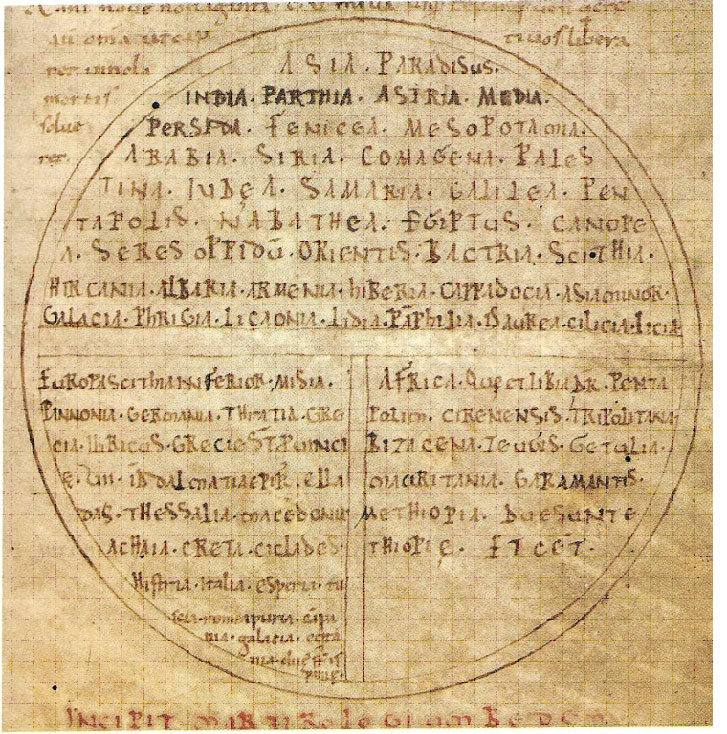
Fig. 4 – A typical T-O type European world map by Venerable Bede, from the 11th century England. It shows the disc shaped world with East at the top. This is divided into the three continents by the vertical line of the Mediterranean Sea, and horizontal waterways of Don on the left and the Nile at the right. Country names are listed in the space allocated for the continents. The eighth line of the names listed in Asia reads Hircania, Albania, Armenia, Hiberia [Kartli], Cappadocia and Asia Minor.
During the eighth century, the Spanish Benedictine monk Beatus of Liebana created his own more decorative version of a T-O map (see Fig. 5). This style was adopted by others, giving rise to a number of similar maps, called Beatus maps. In most Beatus maps Armenia is featured prominently, located next to Paradise and south of the Caucasus Mountains.
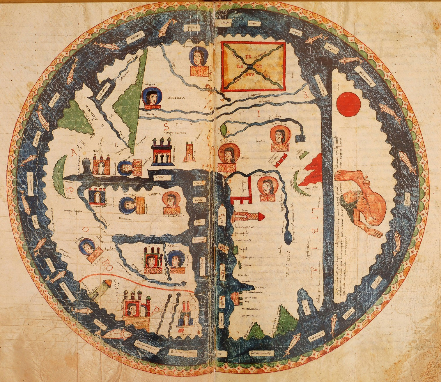 Fig. 5 – This is a world map prepared for Beatus’s Commentarium in Apocalipsin, dating from the eighth century. This is an elaborate T-O map with east at the top, where Paradise is shown. Left of the map the name “Armenia” is inscribed below the Caucasian Mountains (green). The vertical blue mass is the Mediterranean Sea with its abundant islands. The heads represent the ten Apostles placed where they preached.
The small and simple T-O maps gradually gave way to more elaborate ones, depicting towns, cities or even some fauna and flora. Two of the most important and large scale maps of this type are the Ebstorf Map, which had a diameter of about 3.6 metres (destroyed during the Second World War) and the ‘Mappa Mundi’ (World Map), dating from the thirteenth century, kept in the Hereford Cathedral, England. Both these maps show Armenia in the relatively correct geographical position, with particular attention being paid to Noah’s Ark and Mount Ararat. The third similar map is kept in Vercelli, Italy but was heavily damaged during careless restoration work.
Armenia in Islamic cartography
While in the west geographers and cartographers were made to think and work within parameters set by the Church, in the East the Persian and Arab scientists continued to work unhindered by religious dogma. Regrettably, although medieval Islamic world was much advanced in science and astronomy, somehow their advances in cartography did not continue after the thirteenth century.
One of Islamic cartography’s most important foundations is the Balkhi School of geography and maps, which generally described the Islamic countries located in the Persian Gulf, Caspian, Arabian and Red Seas, the eastern Mediterranean and the Indian subcontinent. However, Armenia, together with Russia and Bulgaria, does appear on most Islamic world maps, some of which also include the names of other European countries such as Spain, France and Germany. (See Fig. 6).
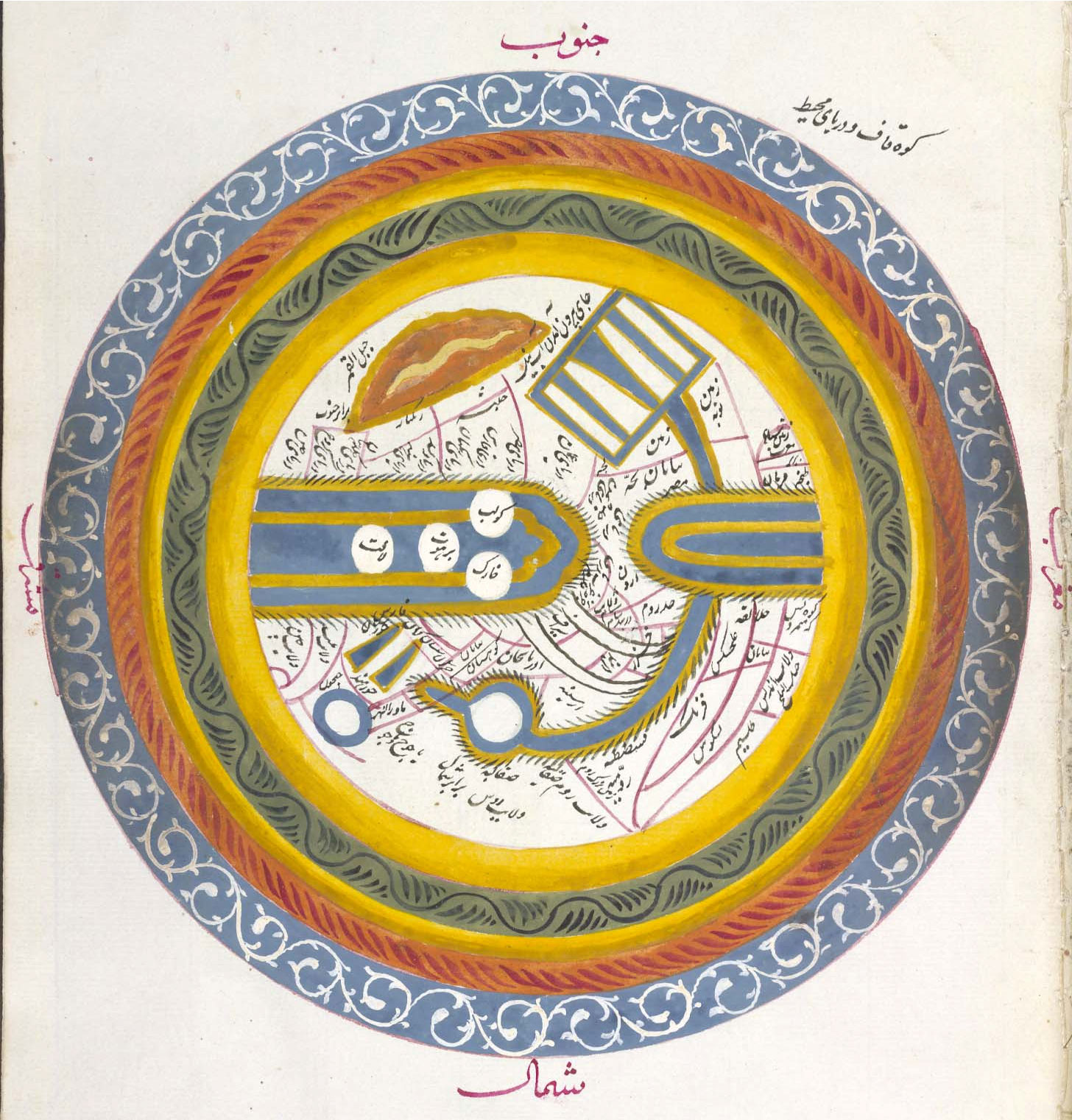 Fig. 6 – The tenth century World Map of Istakhri is one of best examples of the Persian cartography (copy made in 1836). As per Islamic cartography practices, south is at the top of the page. The two gold lined blue inward pointing fingers are the Indian Ocean (left) and the Mediterranean, which is extending north represented by the curved waterways of the Aegean and the Black Seas, eventually connecting to the Caspian Sea (gold-blue circle with white core). Armenia is found between the Caspian and the Black Seas and the Iranian province of Azerbaijan is placed to its south.
There are a number of important cartographers in the Islamic world including the Persian geographer and scientist Abu Reihān al-Birunī (973–1048 CE), who travelled extensively and wrote books on geography, other Persians such as Ibrāhim Ibn Mohammad al-Fārsi, known as al-Istakhrī (died c. 957 CE), al Muqaddasi (945-1000CE), Sadiq Isfāhānī and Abu Zakarīyā Ibn Muhammad al-Qazwīnī (1203–83), Arabs Ibn Hauqal (d. 934 CE) and Idrissi (1099–1166 CE).
All of the above geographers have produced books describing the world, countries and peoples. As mentioned above, all Balkhi school books contain a world map, as well as 16-20 regional maps, depicting mainly the Islamic world. The only exception being the Christian country of Armenia, which is included on the regional map dedicated to the South Caucasus. This regional map is entitled “The map of Azerbaijan, Arran and Armenia”, where Azerbaijan is placed south of the Arax River as one of the Iranian provinces and Arran (Caucasian Albania), always placed north of the Arax. Armenia is shown straddling the Arax and extending westward (see Fig. 7). For details of 20 Islamic maps see Rouben Galichian, Countries South of the Caucasus in Medieval Maps. Armenia, Georgia and Azerbaijan, London: Gomidas Institute, 2007.
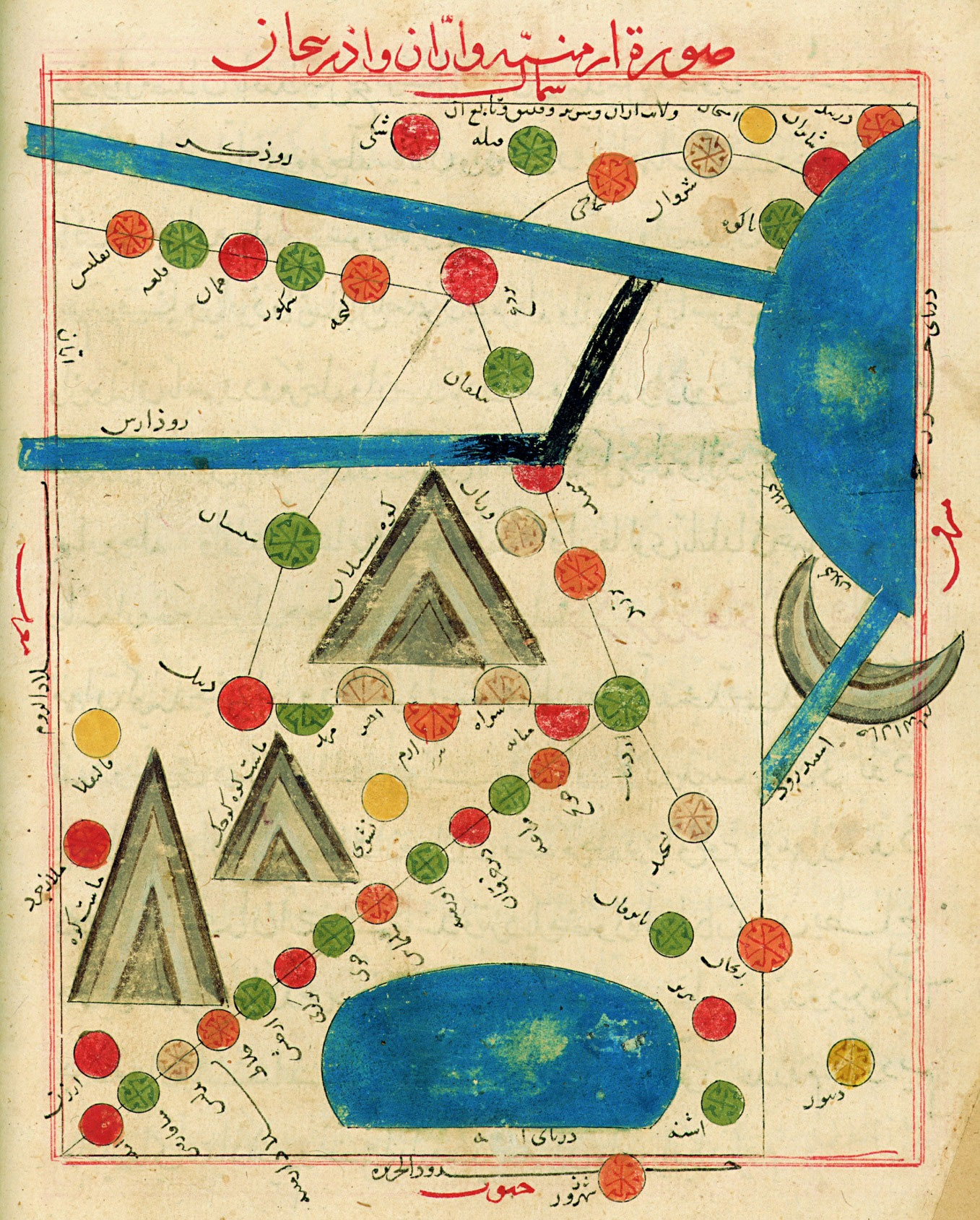 Fig. 7 – Istakhri’s Map of Armenia, Arran and Azerbaijan, has North at the top, which is unusual for Islamic maps. The blue mass on the right is part of the Caspian Sea, with the rivers Kura and Arax (on top) and Sefid-Rud at the bottom, flowing into it. Cities of Arran (Caucasian Albania) are placed north and south of the Kura, Armenian cities are around the river Arax and Lake Van. Azerbaijani cities are at the south-east of the map, below the River Arax. The twin triangles are the Ararat Mountains and the other large mountain is Mount Sabalan in Iran. In spite of Azerbaijani claims, the Islamic maps prove that Aran (Albania) and Azerbaijan are not the same country but two distinct ones, which have existed concurrently.
During what could be called the Norman-Arab period of cartography, this science became more advanced. The most famous of Arab geographers of the era was Ibn al-Sharif al-Idrisi or Edrisi (who was born in Ceuta, Morocco, and studied in Cordoba). After his extensive travels to many parts of the world he was invited to work for the Norman king Roger II of Sicily, for whom he produced a silver globe of the world inscribed with the contemporary map of the known world. In his maps Idrisi includes the countries of Greater Armenia and Lesser Armenia. His atlas of the world known as The Book of Roger also includes much detail about Armenia and names many Armenian cities.
In Ottoman Turkey the most important geographers of the seventeenth century were Mehmet Zilli Ibn-Dervish (1611-1684) better known as Evliya Chelebi, who was a traveler and wrote books about his travels in the neighbouring countries, and Mustafa Ibn- Abdullāh (1609–1657) known as Kātib Chelebi or Hāji Khalīfah, who also travelled widely and produced the first important geography book called Jehān Numā, describing various parts of the world. In addition to detailed descriptions, their manuscripts refer extensively to Ottoman and Persian-occupied Armenian territories and cities, accompanied by some map sketches.
The Portolan Chart and Armenia
Portolans are marine charts and maps prepared for the seafaring peoples, generally depicting the shorelines and ports of the Mediterranean. They were used mainly by the pilots and navigators. Greater Armenia being a landlocked country should not have been included on these charts. Cilician Armenia, however, being an independent kingdom from the eleventh to fourteenth centuries located on the north-eastern shores of the Mediterranean Sea, would be expected to feature on these marine charts, majority of which were produced between the twelfth and sixteenth centuries.
Portolan maps usually show a detailed coastline with the names of all the coastal towns, estuaries, inlets, bays, promontories, rivers, underwater obstacles, reefs and other prominent features accompanied by the lines of the compass, called rhumb-lines, and directions of the prevailing winds. Anything that would interest the ship’s pilot and assist in navigation was shown in as much detail as possible while inland details were not shown. Most of the maps have blank areas for the inland spaces, filled with decorations and cartouches. Portolans were drawn on parchment and were almost always coloured, since the colours provided additional vital information for the captains, such as showing town sizes and their importance, as well as indicating whether the coastline was friendly or not.
Portolans of the Mediterranean include much information about the coastline of Asia Minor in the Black Sea as well as all the Mediterranean shores. The Armenian kingdom of Cilicia, located in the north-eastern corner of the Mediterranean, features prominently in many Mediterranean portolans of that period, sometimes surrounded by a green arch. This was predominantly due to the fact that the ports of Cilician Armenia were Christian ports, and the mapmakers wanted to show them as friendly to the European seafarers. Greater Armenia, being landlocked, would normally not be expected to appear on portolans, since it was out of their useful range. However, this appears not to be true.
In the Italian and Catalan portolans of the Mediterranean area details of the coastlines are shown amazingly accurate and consistent, generally being very advanced for their time. The curious fact is that on majority of the portolans of the East Mediterranean area Armenia also appears. Armenia Maior (Greater Armenia) is generally depicted with a range of mountains, which are shown as the source of the Rivers Euphrates and Tigris, sometimes as well as a third river, the Arax, flowing from these mountains north and west towards the Caspian Sea. These maps also show Mount Ararat placed in Armenia, with Noah’s Ark perched on top (usually shown sideways) and many include the Armenian populated cities of Arzenga (Erzinjan) and Malatia. (See Fig. 8)
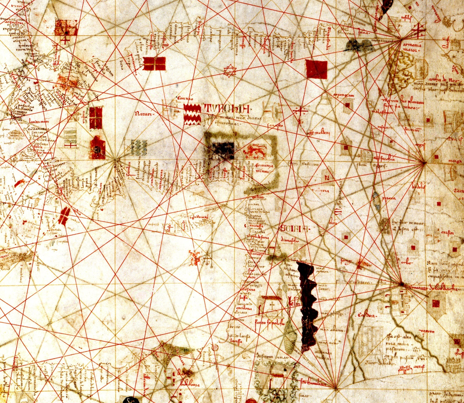 Fig. 8 – This is the eastern section of Dulcert’s portolan chart of the Mediterranean, dating from 399. The toponyms in small script denote the names of the ports and other coastal features, written perpendicular to the shoreline. Top half of the map, with blank interior is Asia Minor inscribed “Turchia”. The lower blank part is the eastern end of the Mediterranean Sea. In the north- eastern corner of this sea, separated by a green border is the Cilician Kingdom of Armenia, described as “Armenia Minor”. The green border indicates that these are friendly ports for the Crusaders. On the top right the twin green mountains are described as Mons Taurus, which are the source of Euphrates (lower left) and the Tigris Rivers (lower right). To their east we see Armenia Maior, and the sideway drawn twin peaks of Mount Ararat, with Noah’s Arc perched on top. This is a most unusual detail to be included on a portolan of the Mediterranean, but most of the portolans of the period do depict similar features, while the rest of the area covered by the same charts remain devoid of any toponym or features.
This was probably due to fact that the country was well known in the West, because of the activities and information obtained form the Armenian merchants who were established in Venice, Amsterdam and other European centers of trade, trading with the countries in the east. Armenia may also have been known in the west and the Christian world, due to the fact that in the year 301 it became the first country to adopt Christianity as its official state religion and its was the easternmost Christian country. Since then Armenian communities were established in Jerusalem where, today, the Armenian Monastery of St James is one of the guardians of the Holy Places, Constantinople and many European cities.
The Late Medieval period.
The last quarter of the fifteenth century saw two important developments in the world of cartography. First – Gutenberg invented the movable type printing press, facilitating the printing of Ptolemy’s Geography. Second – towards the end of the century, Columbus discovered the New World, throwing the world of cartography into turmoil of new discoveries and redrawing of all world maps.
At the end of the fourteenth century when the Turks reached the neighbourhood of Constantinople some of the manuscripts from its libraries were transferred to Italy for safekeeping. Ptolemy’s Geography was among these. Later, scholars translated the Geography volumes from the original Greek into Latin and as stated previously, many cartographers such as Donnus Germanus, Sebastian Münster, Martin Waldseemüller, Berlinghieri and others started preparing maps according to the Ptolemaic texts and coordinates, which accompanied the original texts of their newly prepared atlases. To begin with, these books were in manuscript form but soon printing took over and various publishers started to produce printed versions.
There was a profusion of Ptolemaic maps and atlases coming out of the presses of Rome, Milan, Florence, Ulm and Basle which, with a few exceptions, were based on the Ptolemaic maps having Armenia Minor as the ‘First Map of Asia’ and Armenia Maior as the ‘Third Map of Asia’. (See Fig. 3 above).
One of the characteristics of the maps printed during the sixteenth and seventeenth centuries was the addition of elaborate decorations and embellishments used in their presentation. The cartouche, which was originally intended to frame the title of the map, was now an elaborate artwork sometimes occupying a large portion of the printed page, aimed at making the map more attractive and desired object.
Some of the well-known European geographers and cartographers of the period who have produced maps and atlases of great importance are the following:
- Martin Waldseemüller (1470-1520)
- Sebastian Münster (1489–1552)
- Gerardus Mercator (1512–1594)
- Abraham Ortelius (1528–1598)
- Willem Janszoon Blaeu (1571–1638) and his son Johannes (1596–1673)
- Christopher Saxton (1542–1610)
- John Speed (1552–1629)
- Henricus Hondius (1587-1638)
- Jan Jansson (1588-1664)
- Nicolas Sanson (1600–1667) and others
Most atlases of the above cartographers include a map of the Turkish Empire, which shows Armenia divided between the Ottoman and Persian Empires. Although not having an independent country, the name of Armenia appears on the territory surrounding Lake Van, Lake Sevan and Mount Ararat, since here were the lands where the Armenians were autochthonous. (See Fig. 9).
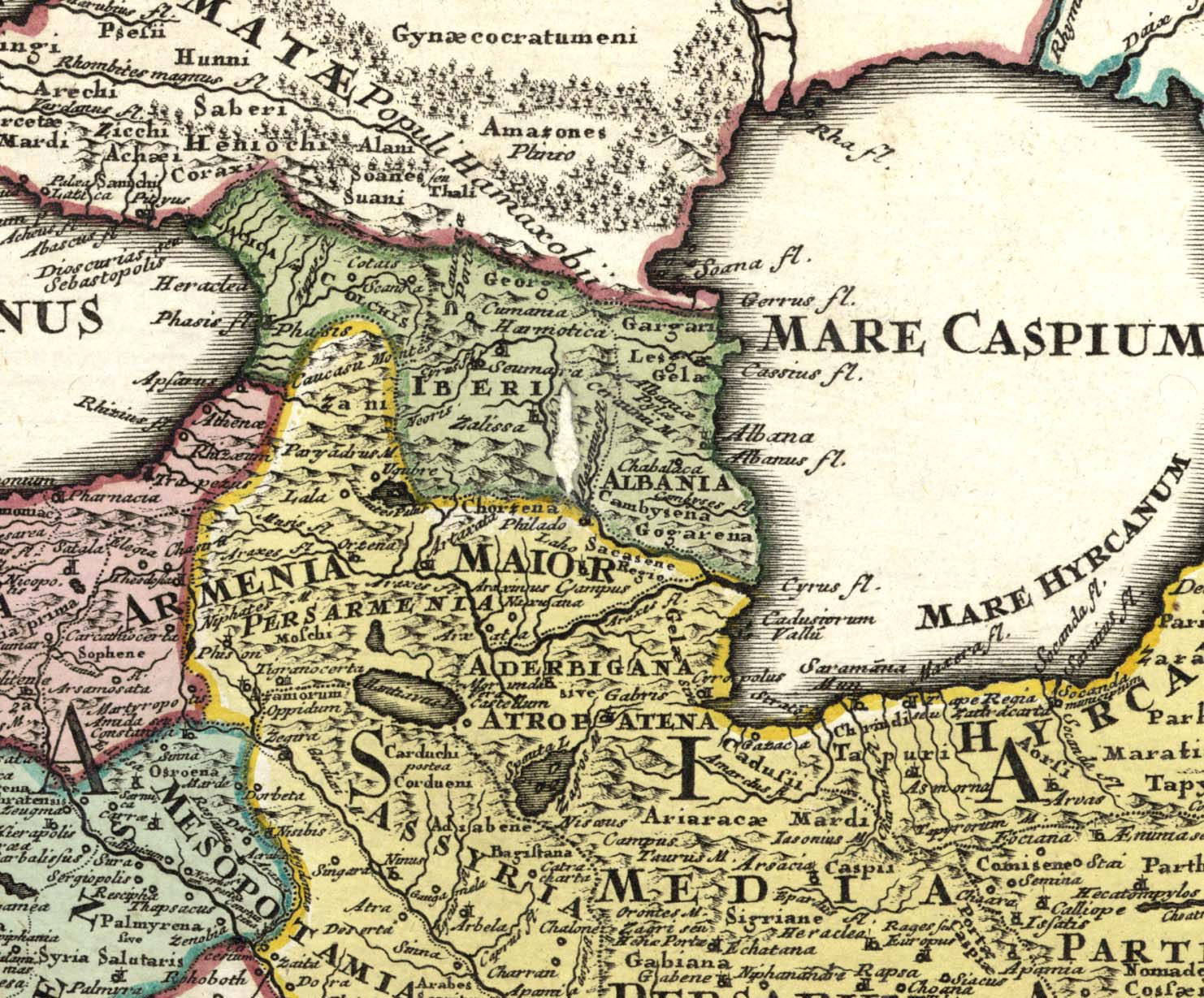 Fig. 9 – Above detail of the area between the Black and the Caspian Seas is from Kohler’s 1718 map Historic Orient. Armenia is divided between the Ottoman and Persian empires and is shown extending from Amid (Tigranakert) to the confluence of Kura and Arax Rivers. Aderbigana or Atropatena (Azerbaijan) is the north-western province of Iran, south of the Arax River, while the territory of the present-day Republic of Azerbaijan is named Albania, placed north of the River Kura and east of Iberia (Kartli).
Guillaume Delisle (1675–1726) produced many atlases such as the “Atlas de Géographie” in 1707 as well as the “Atlas Russicus”, the first large-scale atlas of Russia, in 1745. This atlas includes maps of the Caucasus, the Caspian Sea, Persia and Turkey. On these detailed maps one could see that Armenia was shown over an area extending form Mush to Artsakh. Azerbaijan is shown as the north-western Province of Iran, south of the River Arax and, the territory north of the river is named Shirvan, Shaki etc. It could be clearly seen on all maps that until 1918 there was no Azerbaijan existing north of the Arax, while Atropaten-Azerbaijan did exist as an Iranian province, always situated on the southern shores of the River Arax. (See Fig. 10).
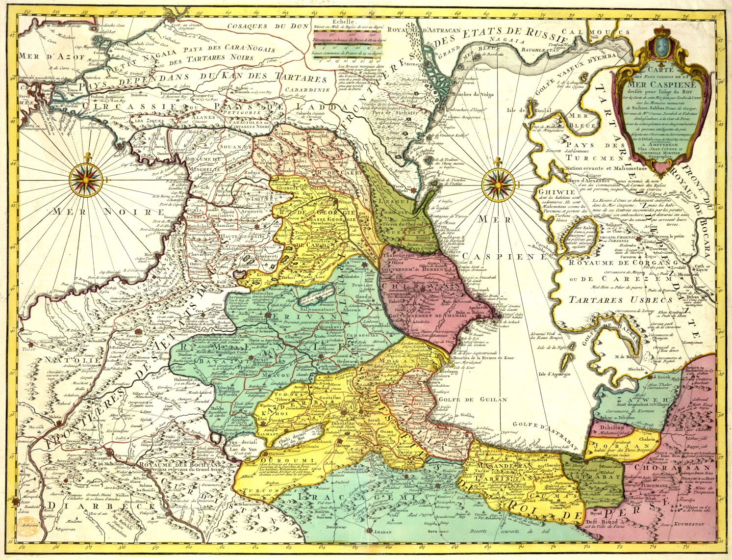 Fig. 10 – Guillaume Delisle’s 1730 Map of the Caspian Sea and its Neighbouring Territories clearly shows that Azerbaijan (yellow) is the province south of the Arax and is part of Iran. To its north, across the river are the lands called Chirvan, Chamaki, Derbent and Tabassaran, presently occupied by the Republic of Azerbaijan. Armenia (green) covers all of Eastern Armenia as well as most of the Western Armenia.
Armenian cartography
The oldest Armenian geographical volume, the Ashkharhatsuyts (pronounced Ash-khar- ha-tsuyts – World Mirror), was penned between 591 and 610 CE and is attributed by most to the Armenian mathematician and geographer Anania Shirakatsi.3 The work has its roots in a text by Pappus of Alexandria, which in turn was based on Ptolemy’s works. However, the text of Ashkharhatsuyts includes much more detailed information and data on Armenia, South Caucasus and Persia (see end note 3). The book, written in classical Armenian, has been translated into modern Armenian (end note 4), Latin (end note 5), French (end note 6) and German (end note 7), as well as reprinted with an introduction in English (end note 8). Some specialists believe that originally the text was accompanied by maps and but although two versions of the book exist in manuscript as well as printed form, no maps have reached us. In the eighteenth century a map of historic Armenia was printed at the St Lazarus (San Lazzaro) Armenian Monastery of Venice, prepared and etched according to the descriptions provided in Ashkharhatsuyts. (See Fig. 11).
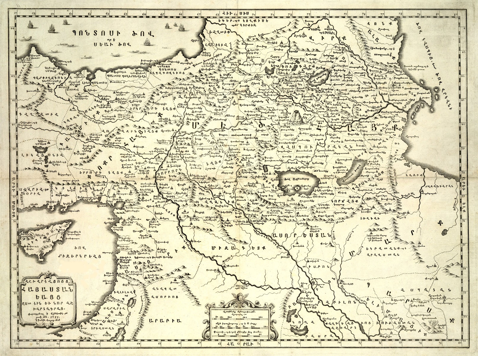 Fig. 11 – Here is the Map of the Armenia as per the Ashkharhatsuyts printed in St. Lazzaro in 751. As evident form the title, the cartographer has used the text of the seventh century geography book for reconstructing the map of Armenia of the time.
Some Armenian medieval manuscripts include T-O-type and climatic zone maps of the world, bearing the influence of Christian and Islamic cartography. These form part and parcel of the development of Armenian cartography, which led to the printed maps of the seventeenth century. The oldest circular map in Armenian dates from the thirteenth to fourteenth century. This is a T-O map, with all the attributes of this type of maps. This small map is kept in Matenadaran, bound in a manuscript from Kaffa (Theodosia) of Crimea. (See Fig. 12).
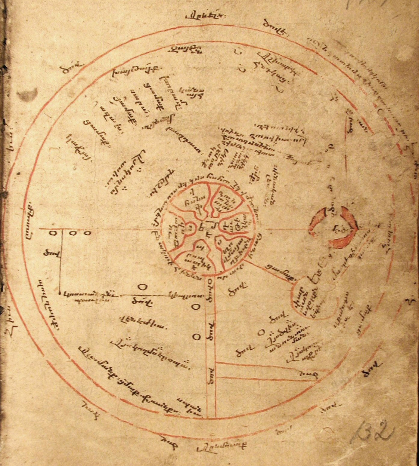 Fig. 12 – This T-O map is the oldest Armenian map dating from the 14th century, kept in a manuscript of various articles in the Matenadaran, Yerevan. It has east at the top and shows the circular world with Jerusalem and its six gates, drawn disproportionally large, placed at its centre. On the top semicircle – Asia – we can find the cities of the Silk Road, extending from Zayton and Kansayh in China to Kaffa on the Black Sea. Other trading cities of Sarai, Khawrazm, Azokh, as well as Mardin, Baghdad, Damascus, Venice, Cyprus are also shown. The Red Sea is placed between Asia and Africa (below right) and is painted red.
During the preparations for a cartographic exhibition in 1991, the authorities at the University of Bologna came across a roll of cloth, which, when opened was discovered to be a manuscript map almost 3.6 metres long and 1.2 metres wide in full and glorious colour. The only problem was that the writing was in a language unknown to them. As the roll cover bore a title that included the word ‘Armenia’, the authorities contacted Gabriella Uluhogian (Uluhojian), professor of the Armenian language at the university, for guidance. She was amazed to discover that the map was in fact in Armenian and was a huge manuscript showing the locations of the important Armenian churches, monasteries and Catholicosates (see endnote 9) of Anatolia and the entire area of historic Armenia, from Karabagh (Artsakh) to Constantinople, including Cyprus and Jerusalem. The two cartouches of the map contained a detailed description of the hierarchy of the Armenian Church as well as details about the reason for the map’s preparation. The map bore the date 1691 CE. (See Fig. 13).
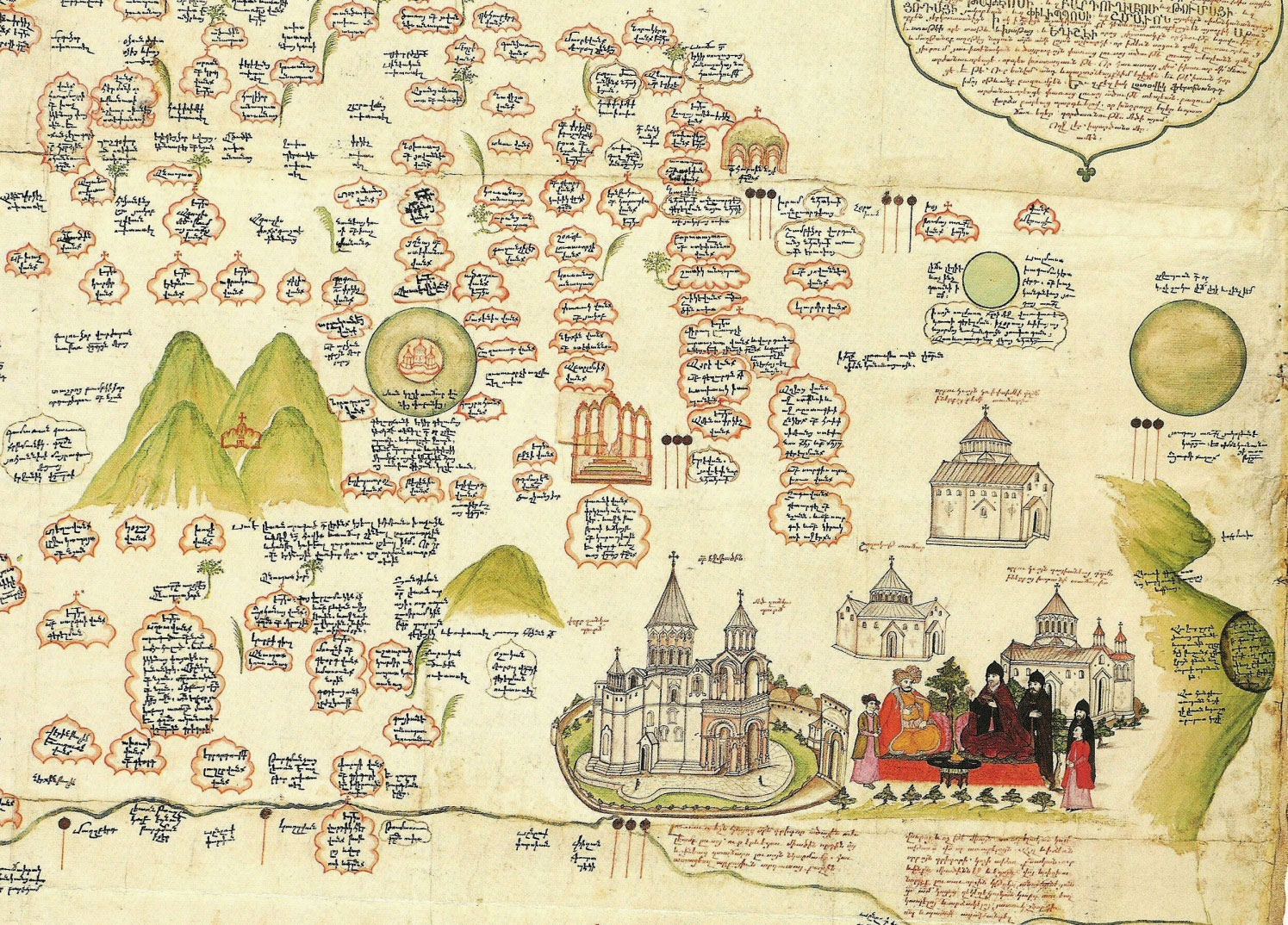 Fig. 13 – This is a detail from the second oldest Armenian map dated 1691, made by the famous Armenian scholar and politician Eremia Cheleby Keomurjian (1637-1695) in Constantinople. It shows all the important Armenian churches, monasteries and religious centres. Here we see Mount Ararat near Echmiadzin, where the Catholicos is entertaining the Persian Sardar, The four peaked Aragatz is north (left) of Echmiadzin with the Monastery of Saghmosavanq and other churches found nearby, each with a relevant description in a cartouche.
The third oldest Armenian map is the World Map printed in 1695 by Tovmas Vanandetsi in Amsterdam. This consists of the two hemispheres, America and Australia being incomplete. The cartographers being of Dutch origin had utilised all the latest cartographic information and up-to-date styles used in the Netherlands of the time. The map is beautifully prepared and elaborately decorated. At each corner there are scenes related to the four seasons as well as astrological and mythological figures.
A large-scale atlas of the world was printed in Venice in 1849, with maps of the world, the solar system and each continent, as well as maps of the Ottoman Empire and Armenia, all beautifully laid out and coloured. This is considered to be the first full atlas in the Armenian language.
The Monastery of St. Lazarus and its printing house have a significant place in Armenian cartography, as from the early eighteenth century for almost two hundred years the most important maps in the Armenian language were printed there. (See Fig. 14 ).
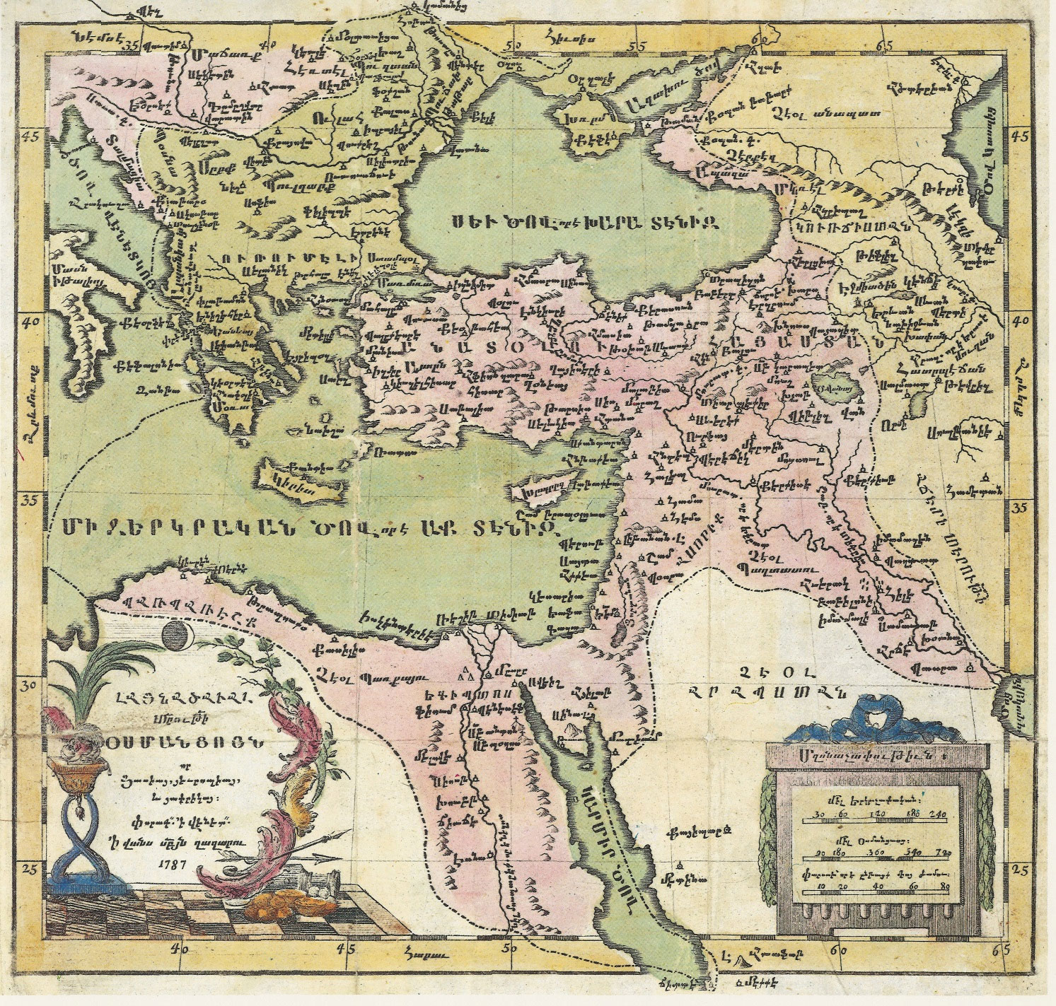 Fig. 14 – This simple and beautifully executed Armenian language map of the Ottoman Empire was printed in the Venetian Armenian Monastery of St. Lazzaro in 1787. As per the political situation of the day, Armenia was divided between the Ottoman Empire and Persia, whose domain in the north extended to the Caucasus Mountains.
The Map after the Nineteenth Century
Since the middle of the nineteenth century, maps have become more accurate and reliable, their differences lying mainly in such relatively minor matters as place-names, scales, projection and detail. It took much time and effort on the part of many geographers and cartographers to achieve this greater reliability. During the same period, in some maps the name of Armenia was gradually being substituted with other more ‘acceptable’ terminology, depending on who was the producer and where the map was printed. However, the reasons behind these changes were political rather than cartographic.
Global cartography reached maturity in 1891, when the Fifth International Geographic Congress approved the execution of the International Map of the World with a scale of 1/1,000,000. It was only after this final decision that the world could be properly surveyed, pending peace and the proper cooperation of the member states, both of which conditions are often elusive, even today.
ENDNOTES
- British Museum, ref. BM92687. See Rouben Galichian, Historic Maps of Armenia, (London: 2004), 36.
- See Rouben Galichian, Historic Maps of Armenia, 37.
- Anania of Shirak, who lived in the seventh century CE.
- G.B. Petrosyan, Shirakaci (Yerevan: 1979) (in Armenian).
- G. and W. Whiston, Historiae Armenicae, Libri III (London,:1736).
- M.J. Saint-Martin, Memoires Historiques et Geographiques sur l’Arménie, tom II (Paris: 1819), 310–394. P.A. Soukry ( Venice: 1881).
- J. Marquart (Berlin: 1901).
- Prof. Robert Hewsen (New York: 1995).
- Churches located in various regions of Armenia came under the rule of different religious centres, called Catholicosates.
BIBLIOGRAPHY
For many more maps as well as detailed and comparative studies and articles of wider ranges of maps of Armenia both in Armenian and English refer to the following works of the author.
- Historic maps of Armenia. The Cartographic Heritage. London: I.B Tauris, 2004.
- Armenia in World Cartography (Armenian and Russian). Yerevan: Printinfo Art Books,
- Countries South of the Caucasus in Medieval Armenia, Georgia and Azerbaijan. London: Gomidas Institute, 2007.
- A Medieval Armenian T-O Imago Mundi, Vol. 60 Part 1, 86-92. London: Routledge, 2008.
- Clash of Histories in the South Redrawing the map of Azerbaijan, Armenia and Iran. London: Bennett & Bloom, 2012.
This article was published in:
Journal of Armenian Studies, Armenian National Academy of Sciences, Yerevan, 2013 – 1 (1), pp. 83-107
© Rouben Galichian. Yerevan 2013.