The new terminology of “Western Azerbaijan”
Available at: Free Download
The NEW TERMINOLOGY of “WESTERN AZERBAIJAN”
By Rouben Galichian, Yerevan
Since the middle of the twentieth century, the authorities and pseudo-academics of the barely decades–old country, the Republic of Azerbaijan, began the process of establishing their republic as an ancient country, laying claim on the lands of all their neighbouring countries. This process began from the day the Republic of Azerbaijan was established in 1918, appropriating the name of the neighbouring homonymous Iranian province.
Two decades after their establishment, the Azerbaijani authorities pushed forward with their fabricated and invented facts, with publication of articles, books and other propaganda means, aimed at establishing an ongoing monologue about their “ancient” history. This activity was expanded hugely under the leadership of the current president Ilham Aliyev.
Their focus was on the assumption that, if long enough one keeps repeating false news, especially in the absence of opposing information, the fallacy gradually becomes the norm, and finally turns into reality, accepted by all.
In order to have a western and southern Azerbaijan, the authorities of the present day Republic of Azerbaijan base their claims on the historic past of their own country, Azerbaijan, asserting that this so called “ancient” land is the hub of all Azerbaijanis, thus extending their claims over the territories of their southern and western neighbours. Today the Azerbaijan authorities claim that Armenia to the west is actually the historic western part of Azerbaijan and the Iranian province of Azerbaijan is actually the southern part and their country, which during the early 19th century Russia and Iran divided it into two parts, appropriated by themselves. They even have begun calling their own country “Northern Azerbaijan”, in order to assert their ownership over the Iranian province of Azerbaijan, named “Southern Azerbaijan”.
All historic writings and maps prove that south of the Caucasus Range and north of the Arax River there was no country named Azerbaijan until 1918. In ancient times the region was known as Caucasian Albania (Arran in Persian and Arabic and Aghvanq – in Armenian), and from the eighteenth to the twentieth centuries the regions was known as “Shirvan”.
The only ancient Azerbaijan that has existed was the Iranian province, which today are split into east and west Azerbaijan and Ardabil provinces. Before the Common Era this entire area was known as Lesser Media. The change of name came about after the country was defended by their military leader named Atropat against the forces of Alexander the Great. Later the population of the country decided to name their land Atropatene, in honour of their military leader. After the Arab invasion the name gradually evolved and became Aderbigan, Adherbijan, Azerbijan and Azerbaijan. However, the ancient name has persisted in Armenian and they still call it “Atrpatakan”.
The fact that Azerbaijan has not existed on any historic map extant from the ancient times to the year 1918, has no consequence on Azerbaijani claims and falsifications. All of their claims are based on a single sheet of map, prepared in 1844, where a British mapmaker erroneously inserted the name “Azerbaijan” between the names of “Armenia” and “Georgia”. However, on the other maps of the same Atlas, the error was rectified and “Azerbaijan” has been shown as a province of Iran.
Notwithstanding the above, Azerbaijan is still organizing Western Azerbaijani citizen groups and societies, to push forward their baseless claims of Armenia being Western Azerbaijan. They have gone so far as appropriating all Armenian Christian monuments calling them Turkic Temples and the whole of Armenian land has been names the lands of the Oghuz Turks, who actually came from the steppes of Central Asian during the eighth to tenth centuries. For details, see the last pages of this article.
It is beyond imagination, how a country, established just over a century ago, could lay claims to her “historic” lands in possession of her well-established and old neighbours?
In order to discover the truth, one has to delve into the history of the region as well as the cartographic sources of the time, and make observation on these matters, available to all.
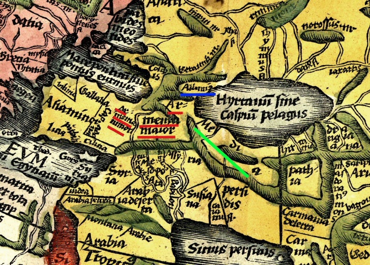
1.1 – The South Caucasus and the Middle East in Ptolemy’s World Map second century.
On map 1.1 we see the toponym of Armenia Maior (Greater Armenia) and Armenia Minor (Lesser Armenia), placed in the Middle East and South Caucasus, both underlined in red. Albania, underlined in blue, is placed north of the Kura River, just south of the Caucasus. There is no Azerbaijan, not even Iranian Province of Azerbaijan, only [Lesser] Media, which was its predecessor, underlined in green.
Now let us have a look at Islamic cartography, which Buniatov refers to, and consider the maps of the South Caucasus. Below are two samples of well-known Islamic maps dating from the tenth century by famous tenth century Islamic geographers Istakhri and Ibn Hawqal.
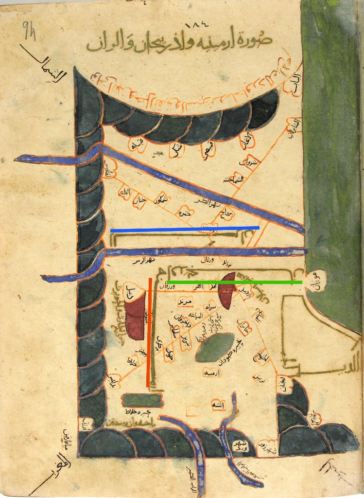
1.2 – Map of the South Caucasus from Ibn Hawqal’s book
Surath ul-Ardh, 10th century. Topkapu Saray, Istanbul.
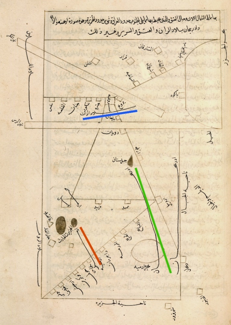
1.3 – Map of the South Caucasus, from Istakhri’s book Mamalik va Masalik. 10th century. British Library, London.
The two above Islamic maps of 1.2 and 1.3 prepared by the famous geographers, show the region of the South Caucasus. Both the maps are entitled the Map of Armenia, Azerbaijan and Arran (Caucasian Albania). Arran is underlined in blue and lies between the Arax and Kura rivers. Azerbaijan is shown as the north-western province of Iran and is placed south of the Arax River, underline in green. This proves that Azerbaijan and Arran are distinctly separate regions, while the present-day Azerbaijani authorities claims them to be one and the same country. There are no northern, southern or western Azerbaijans on any of these Islamic maps? There is only one Azerbaijan, which is the historic Persian province, which used to be known as “Lesser Media”.
On both these maps Armenia, underlined in red, could be seen straddling the Arax River, being located south of Arran and West of Azerbaijani province of Persia-Iran.
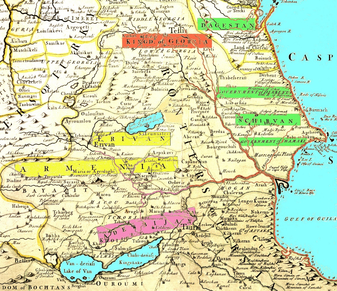
1.4- French mapmakers Delile’s map of the Caucasus in 1730.
Map 1.4 is entitled “Countries of the Caspian Sea Region”, shows the region of the Caspian Sea, with Armenia, Mingrelia, Kartveli, Georgia, as well as Dagestan, Derbend, Shamakhi regions, of which the last three are under their common name of “Shirvan”.
The region presently occupied by the Republic of Azerbaijan is shown being ruled by Muslim Khans (Princes), whose domains are highlighted green. During the time, there were also five Armenian Princes (Meliks), who ruled their regions independently, paying their taxes to the Persian kings. Since 1918, most of this territory, which used to be commonly named as “Shirvan”, has been renamed the “Republic of Azerbaijan”.
On this map the Iranian territory south of the Arax River is named Aderbijan, highlighted maroon, which is the name of the northwestern province of Iran. There is no Azerbaijan north of the Arax River. The names of Yerevan and Armenia are highlighted yellow. This country extends from the River Arax to the south, as well as towards the north and west reaching Bayazid, Sharur, Ararat, Maku, Etchmiadzin (Uchkilisa), Artashat, Dvin, Nakhichevan, Kapan, Lake Sevan, etc.
Here we bring two quotations regarding Azerbaijan, as presented by the Encyclopedia of Islam, printed in 1913 by Brill in figure 1.5 and the Turkish encyclopedia of 1942, in figure 1.6.
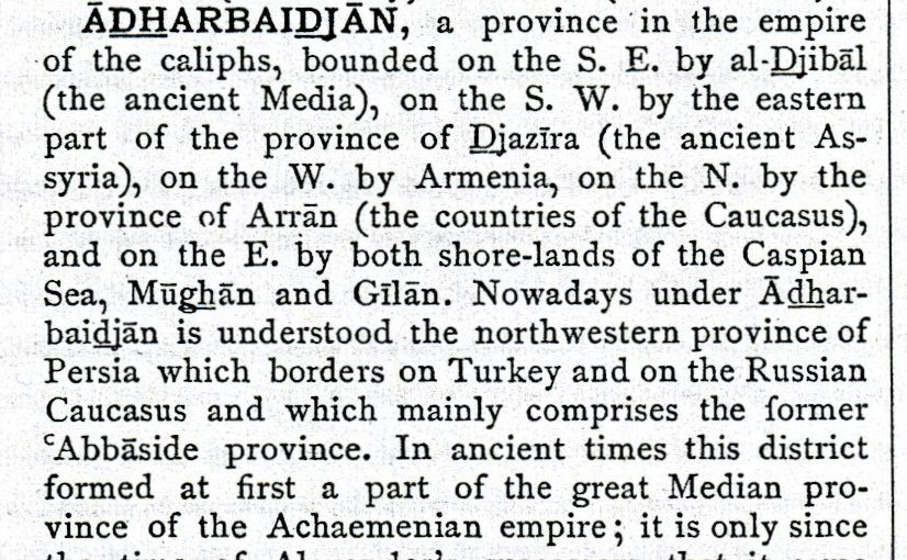
The description is in line with all the other encyclopaedias, books of history and geography of the period prior to 1918, when the Republic of Azerbaijan was not yet born.
1.5 – Encyclopaedia of Islam, 1913. Brill, Netherlands.
Here is another quotation from Islam Ansiklopedisi (Islamic Encyclopedia, in Turkish) published in Turkey, in 1942.
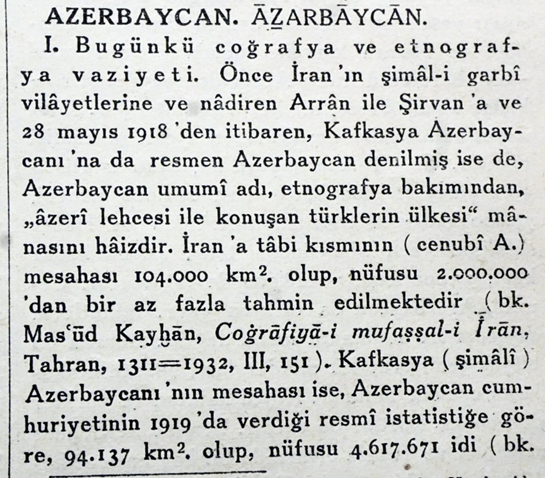
1.6 – Extract from page 91 of the Turkish Islam Ansiklopedisi,
book 12 of the 1942 set.
The loose translation of the text is as follows:
The name Azerbaijan has been used referring to the Iranian north-western provinces and on rare occasions also referring to Arran and Shirvan. Since May 28, 1918 the Caucasian state also has officially been named Azerbaijan.
The closest ally of the Republic of Azerbaijan – the Ottomans, prepared the next two maps. These were published during the nineteenth and twentieth centuries, prior to the establishment of the Republic of Azerbaijan in 1918. The maps date from 1877 and 1913 and on both the region/province of Azerbaijan is shown inside Iran, as the Iranian northwestern province, while the region of present-day Azerbaijan is named Shirvan.
The Ottoman War map of 1877 is presented on figure 1.7. It was prepared by the ancestors of the Azerbaijan’s friends, the Turks, who now wholeheartedly and unquestionably support Azerbaijan. The map was prepared during the Russo-Turkish war of 1877, when the Ottomans lost Kars and its region to Russia.
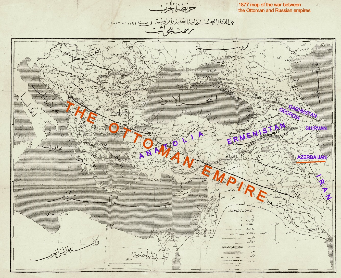
1.7 – This map was compiled by the Ottoman Empire’s Ministry of War, aimed to illustrate the situations of the two countries during the Ottoman-Russia war of 1877.
The toponyms on map 1.7 are shown in Ottoman-Arabic script. As none of the present-day population of Turkey and the west, with the exception of the few Arab and Persian readers, could read them, these have been transliterated.
The largest toponym on the map is that of the Ottoman Empire, extending from the Balkans to the deserts of Saudi Arabia and Iraq, Palestine, Egypt as well as Libya.
The name Anatolia is applied only to the geographical area of the peninsula of Asia Minor, extending from the Aegean Sea to the region of Tokat, Sivas and Adana, and the western banks of the river Euphrates. On this Ottoman map the name Armenia is mentioned on the territories of Erzurum in the north, to Lake Van and Bitlis to the south, as well as Malatia in the west and, and the region of Sevan in the east. All of this is known as the territory of Historic or Greater Armenia. The map covers regions under Ottoman and Russian control, and regions, which fall inside the above-mentioned territory, while Azerbaijan has been shown as a province of Iran, located on the southern shores of the Arax River. Georgia and Dagestan are placed north and northwest of Armenia.
The territory of the present-day Republic of Azerbaijan has been called Shirvan. During the period from prehistory until 1918, there was no country named Azerbaijan on the northern shores of the River Arax.
The next Ottoman map of figure 1.8 brings us to the year 1913. Being prepared before the important year of 1918, we can see that there is no country named Azerbaijan north of the River Arax. The only Azerbaijan is the Iranian province of that name, on the southern shores of the Arax River.
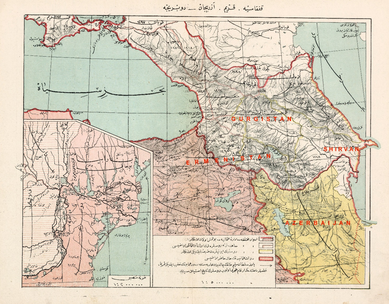
1.8 – Map of the South Caucasus in 1913.
Because at the time the lands of Historic Armenia were divided between the Ottoman and Tsarist Russian empires, the name of Armenia is written across the borders of these two empires. Here the region of the present-day Azerbaijan is shown as Shirvan, a name which, until 1918 was commonly used for the region.
* * *
According to the claims of some local historians, the terminology of Northern and Southern came into use after the treaties of Gulistan and Turkmanchay (1813 & 1828), when the region north of the Arax River was ceded to Russia, splitting the country into two parts. But Buniatov has another theory, which claims that these names are not 100 but 1,500 years old. He claims that:
According to historic map collections, since the sixth century CE the name Azerbaijan is valid to be used for both Northern and Southern Azerbaijans. During the sixth century the Sassanid king Khosrow Anushirvan created the “Caucasian knot” group of countries, entitled “Abdulbadahan”, or, according to Arab-Persian tradition “Azerbaijan”, which, among others, included the countries of Northern Azerbaijan or Arran and Southern Azerbaijan, Atropatene. According to the Arab and Persian sources, since the age of the Caliphate and afterwards, i.e. the eighth century, the name “Azerbaijan” came to be understood as both Northern and Southern Azerbaijans, and refers to their administrative, geographical or political systems.
In this single paragraph from Buniatov there are number of primitive looking but intentional political misrepresentations.
The oldest Islamic historical or geographical work dates from the ninth century, hence the maps mentioned by Buniatov are those possibly prepared by himself and can hardly be considered “credible” ancient documents.
In his second sentence he intentionally distorts the name Atropatene or Atorpatkan into “Abdulbadahan”, a fake Arabic-sounding name unfamiliar to Arab or any other sources. In either case, this was the Iranian province by the name Atropatene, located south of the River Arax which was known to historians since the dawn of our era.
In any case, Anushirvan was a Persian king who would not call his group of nations with an Arabic name. Furthermore, he died in 579 and the first Arab invasion took place in years later, in 632.
As seen on Islamic maps of 1.2 and 1.3 on the Islamic documents that have reached us from the ninth century, particularly in the geographical works of Balkhi, Istakhri, Ibn Hawqal, al-Mas’udi, Idrissi, al-Qazwini and others, the territory north of the Kura and Arax rivers has always been named “Arran”, i.e. Caucasian Albania, and south of the river has been named “Azerbaijan”.
Basing his theories upon his own fabrications, Buniatov tries to assert the political and administrative statehood of Azerbaijan upon a territory stretching from Derbend to Hamadan – see images 1.09 and 1.10.
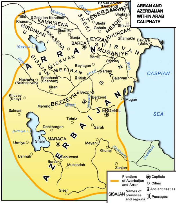
1.9 – Arran and Azerbaijan within the Arab Caliphate, seventh-thirteenth centuries, from “Historical Maps of Azerbaijan”, Baku, 1994.
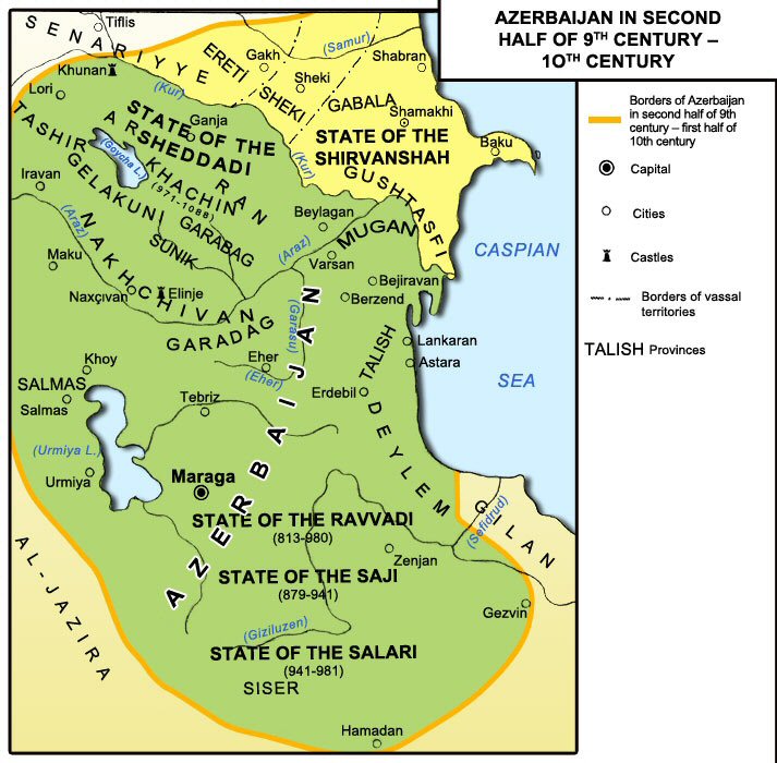
1.10 – Azerbaijan in the ninth-tenth centuries, from “Historical Maps of Azerbaijan”, Baku, 1994. Azerbaijan is bordered by an orange line.
Images 1.09 and 1.10 are taken from Historical Maps of Azerbaijan (1994). Image 1.09 shows the region during the seventh-thirteenth centuries. Here Arran is north of the Arax and Kura rivers, while the region north of the Kura is also named Shirvan. The map is entitled “Azerbaijan and Arran”, which are surrounded by an orange line. These two separate countries are given equal importance and weight.
Image 1.10 shows the whole of the same region entitled Azerbaijan, including the region of Arran mentioned on the previous map. Azerbaijan extends from Derbend to Hamadan, which is marked by the orange border.
These two images are contradictory: one map shows Arran and Azerbaijan being two separate countries, which goes against their claim that Arran was their ancestral land, while on the other this is changed, and Arran is included inside the territory of Azerbaijan.
It is interesting to see that historically two important and oldest countries of the region, Iran and Afrmenia, which appear on all other maps of the region, are not merited any mention in Azerbaijani maps.
As previously noted, in the “academic” literature of Azerbaijani historiography of the twentieth century, we begin to see the terminology “Western Azerbaijan”, a territory whose borders and area had until recently not been clearly defined.
The area of the region referred to under this name became apparent, when the Ministry of Tourism and Culture of the Republic of Azerbaijan in 2007 published a book by Aziz Alakbarli entitled The Monuments of Western Azerbaijan. On page 7 of the book the map of the Republic of Armenia is depicted with the caption stating “Western Azerbaijan”, the homeland of Oghuz Turks, presently occupied by “Armenia”. Thus, finally, as the map 1.11 shows, the present-day Azerbaijani authorities claim that the entire territory of the Republic of Armenia is, in fact, Western Azerbaijan, which had been the land of the Oghuz Turks, who, in fact came from the Central Asia.
This is how Azerbaijan presents its “historical” country to her population, as well as the world.
1.11 – The map of Armenia, renamed “Western Azerbaijan” by Aziz Alakbarli,
in his book “The Monuments of Western Azerbaijan”, 2007, Baku.
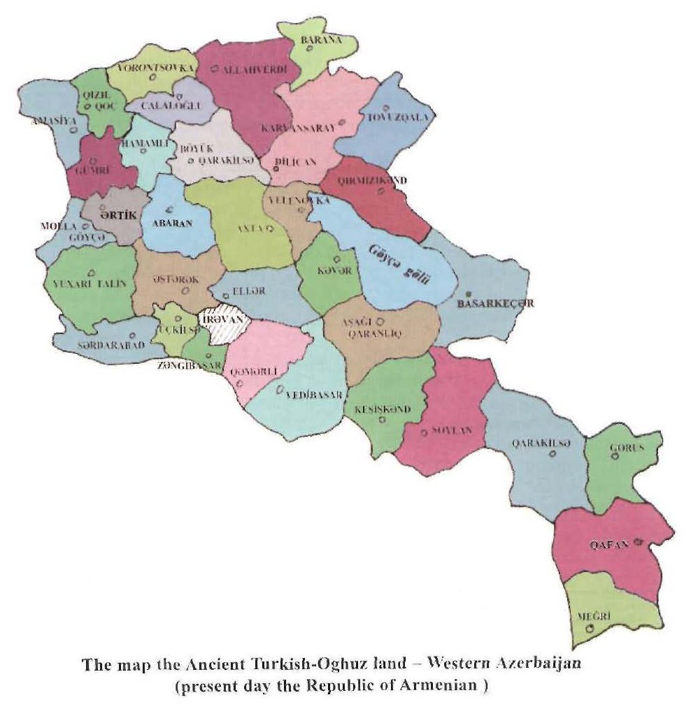
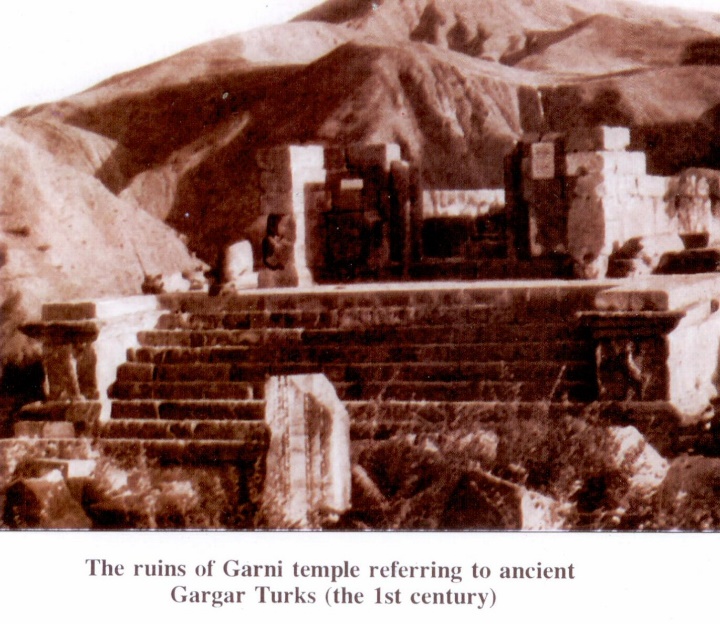
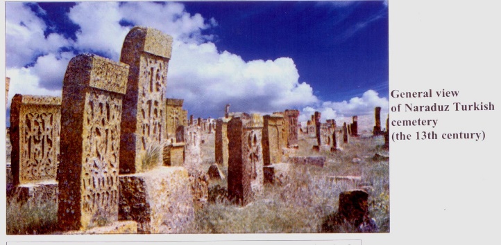
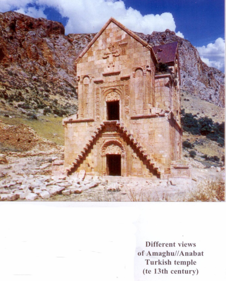
Some of the images of the Armenian historic Christian monuments included in the above mentioned book are taken from the book and reprinted on the next page of this article. All these monuments, dating from 3000 years BCE to the Middle Ages, have been falsely presented as Turkish monuments with the sole purpose of completely refuting the presence of Armenians in the South Caucasus.
If one is to believe the descriptions of the images, Turkic nations, which the Chinese named “Turku” initially during the sixth century, have “actually” been living in the South Caucasus since 3000 years BCE. Also that they have been devout Christians and have built Christian monuments for centuries.
This is the Monastery from where Christianity was brought to Armenia.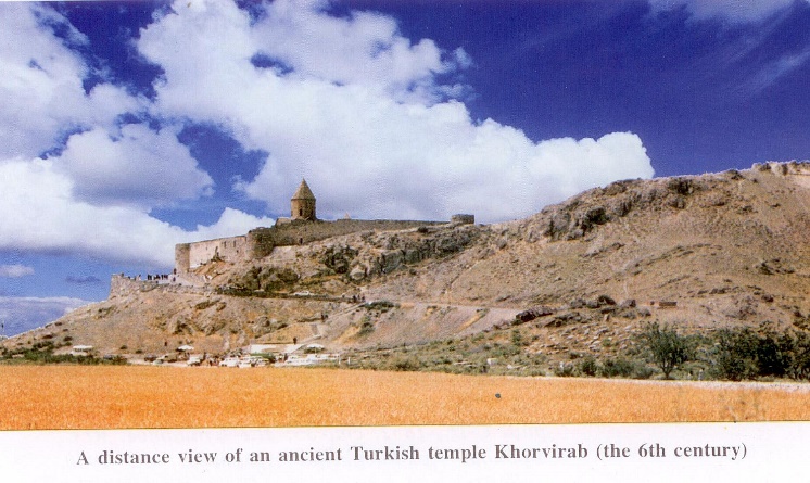
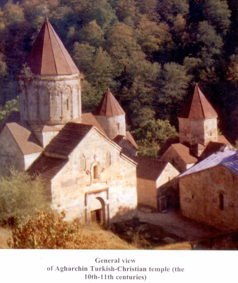
é The Monastery of Haghardzin near Dilijan, Armenia
êThe Monastety of Noravanq near Areni, Armenia
R. Galichian, November 2023, Yerevan