The Islamic Road Maps
By Rouben Galichian
In our day and age the use of automobile has made the road map possibly the most common and widely distributed and used map after the street maps or town plans. One can find all types of road maps and charts almost in every vehicle on the road. But what was their origin? Which were the first road maps?
The oldest document that by today’s definition could be called a road map is the Tabula Peutingeriana or the Peutinger Map, which covers the area of the Roman Empire and stretches from England to Persia and India. This is a map divided into twelve segments, each measuring about 34×56 cm, making it very narrow and long document. As dictated by its shape, the Roman world is flattened by compressing the north-south axis down to 34cm, while the east-west is extended to 6.75 meters. The resultant map is a highly distorted one, where countries and cities are shown in positions merely relative to each other, while the interconnecting roads are indicated by straight red lines, marked with the distances between two adjacent rest houses or towns. The map possibly has its roots in the first century, made into its present shape and form during the third or fourth centuries, but the extant copy dates from only the twelfth to thirteenth century.[See endnote 1] The original of this map may have been intended for the Roman generals and government administrators, in order to help them plan their logistics. Only one copy of the map exists today, kept in Österreichische Nationalbibliothek, Vienna.
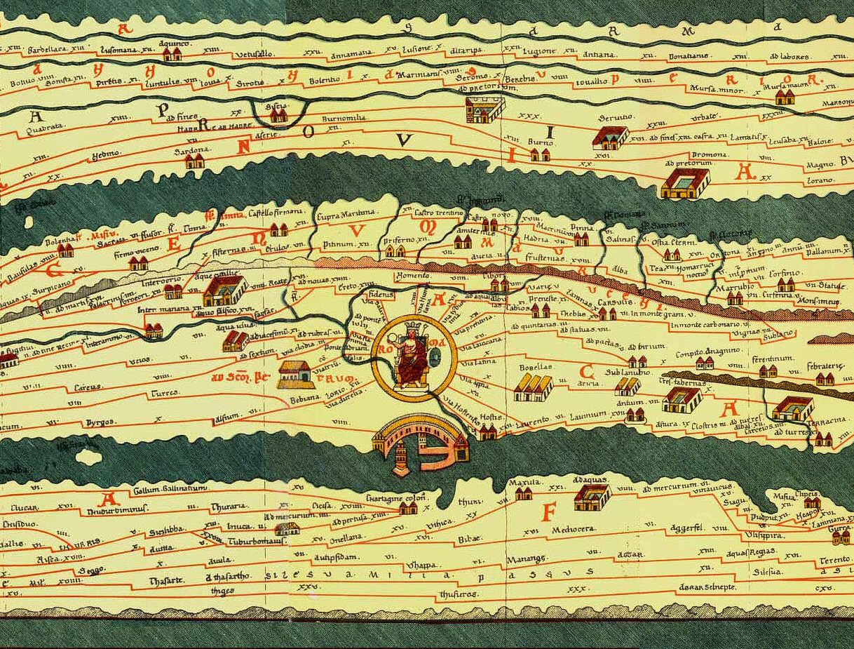 Fig. 1 –A section from Tabula Peutingeriana. Original in Österreichische Nationalbibliothek, Vienna.
After the Tabula Peutingeriana one of the earliest road maps in western cartography is that of Matthew Paris (1200-1259). This map is included in Paris’s Chronica Majora, whose manuscript includes a World Map, with somewhat limited area coverage. In addition to this map there are others, including a map of England and Scotland, a strip type Itinerary or Road Map extending from England to Apulia (Puglia) in Italy and a detailed map of the Holy Land. The road map is intended to give some information to the prospective pilgrim about the route to be taken for getting from England to Puglia, from where they could continue by sea to the Holly Land. This road map consists of a number of vertical strips, showing various important cities located en-route to their destination. Manuscript copies of this map are kept in various UK collections and date from around 1253-4.
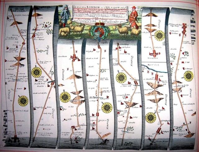
After the Itinerary of Matthew of Paris the best known western road maps are those of the Britannia Atlas of Scottish impresario and mapmaker John Ogilby (1600-1676), published in1675 in London.
 Fig. 2 –Ogilby’s road map of 1685. The map shows the road form London to Wells, Norfolk and Newmarket.
However, after the source material of the Tabula Peutingeriana, which has been lost, the earliest road maps known to us belong to Islamic cartography. These are maps showing cities and interconnecting roads seen on the maps of Balkhī school of Islamic cartography. The school follows the work of Abu Zaid Ahmad ibn Sahl al-Balkhī (died 934 CE), one of the earliest known Islamic geographers, after whom this school has been named. Balkhī was a mathematician and a scholar, who spent his life in Baghdād and during the latter years moved to Balkh, where he wrote his geographical thesis. This was a tome consisting of a number of maps accompanied by the descriptions of the lands depicted on these maps.
His most renowned followers were Abu al-Qāsim Muhammad Ibn Hawqal (traveled 943-973 AD), Abu Ishāq Ibrāhim bin Muhammad al-Farsī al-Istakhrī (died 957 AD) and Muhammad Ibn Ahmad Shamsuddin al-Muqaddasī (945 – c.1000 AD) and others. All their geographical works include a World Map accompanied by 17 to 21 regional maps of the Islamic world, accompanied by their descriptions.[2] It should be noted that most of these so called Islamic geographers were of Persian origin, but wrote their work in the language of the time, Arabic.
In his geographical work Ahsan al Taghāsim fi Ma’rifat al-Aqālim, (The Best Divisions for the Knowledge of the Provinces), which includes 20 regional maps, al-Muqaddasī says, “We should not concern ourselves with the countries of the non-believers, but concentrate on the Islamic countries”. Notwithstanding his above statement, his maps, as well as those of the other manuscripts of Balkhī school, in their regional maps include a map of Azerbaijan (The North-western Iranian province, whose population had converted to Islam), Arran (Caucasian Albania, whose population was Christian) and Armenia or Armaniye (with Christian population).
Here it must be added that Azerbaijan province of Iran shown in these maps is not to be confused with the present day Republic of Azerbaijan, whose territory until 1918 was known as various khanates named Shirvān, Ganja, Shamakhi, Talish, Shaki, Karabagh, Daghestān and others. All these in the medieval times were known as the Caucasian Albania or, in Persian – Arrān, a Christian country, whose name disappeared from the maps around 9-11th centuries. Somehow in 1918, during the mayhem following the World War I, this newly established country was given the name “Azerbaijan”, motivated mainly by political reasons, duplicating the name of the millennia old Iranian province of Azerbaijan.[3] During the tenth century Azerbaijan being an Iranian province, was part of the Islamic world, but the fact that the other two neighbouring countries were Christian did not prevent them having very close commercial and ethnic ties with the Muslim Iranians. Therefore, the regional maps of this region generally include the countries of Armenia and Arrān, as well as the Iranian province of Azerbaijan. The oldest Persian language geographical work entitled Hodud ul Alam, written in 982 AD by an unknown geographer states ”these three regions are adjoining and their people are interlinked”.
Until the twelfth or thirteenth centuries Ptolemy’s seminal work Geographia, which described the known world in much detail, was not known in Europe. During most of the medieval period all western scientists were gradually made to adhere to the religious dogmas and instructions of the church leaders, which did not help the development of geography and cartography. Maps of this period consisted mainly of the T-O and Climatic Zone maps, which gradually became more and more elaborate in the presentation of their content but not necessarily correct in their depiction of the world. This is particularly evident in the western maps made after the criticism and arguments of the sixth century zealot monk Cosmas Inidcopleustes, who was instrumental in tightening religious control over all cartographic works and mapping.
In Figures 3 and 4 we can see two world maps. Fig. 3 is from a western source and Fig. 4 is an Islamic map. The western map shown is a typical medieval T-O map, where the known world is divided into the three continents of Asia, Africa and Europe with schematic waterways of the Mediterranean and the rives Nile and Don marking the borders between these continents. Here, as in most T-O maps, the layout is very approximate at best. Fig. 4 is a medieval world map from Istakhri’s geographical work entitled “Masalik va al-Mamalik”. Here one can easily distinguish the Mediterranean, the Caspian Sea, the Aral Lake and the Indian Ocean with its islands. Even the Gulf of Omman and the Persian Gulf can clearly be seen. The map is an indicator of the more advanced state of Islamic geography of the time.
For ease of comparison the maps have been rotated and both are shown oriented with north at the top.[4]
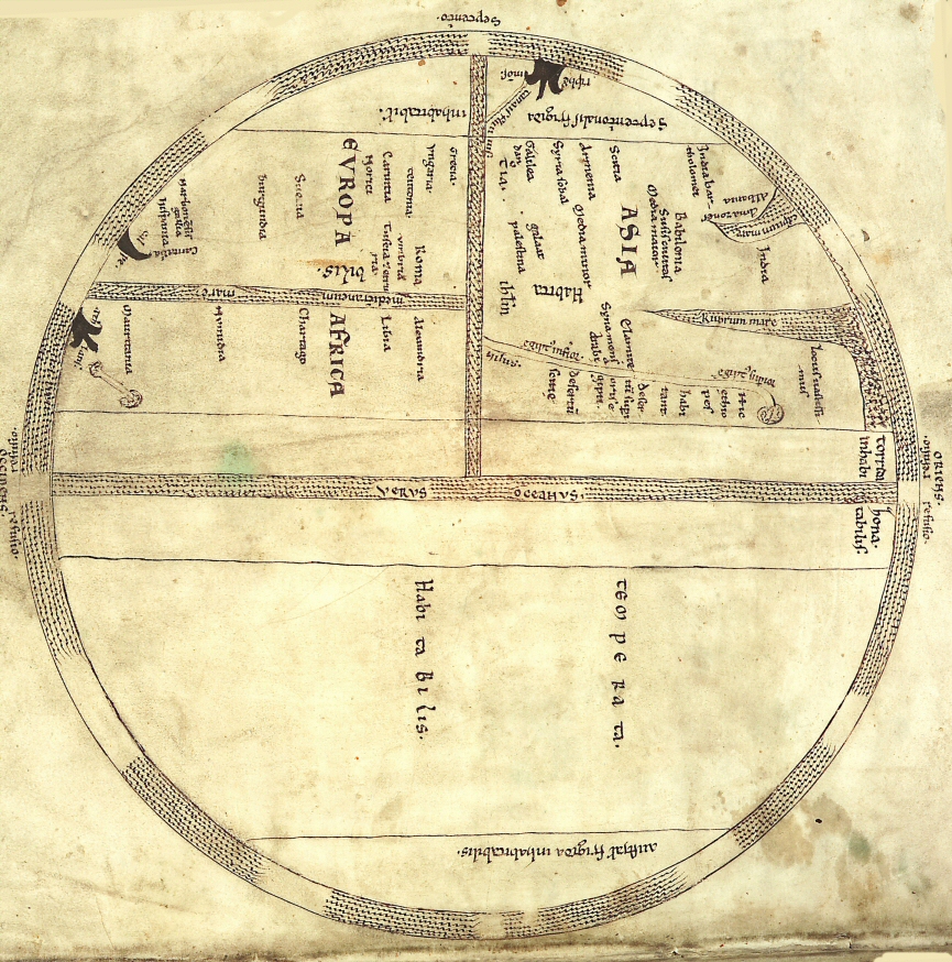 Fig. 3- World map of Isidore of Seville, from a 13th century manuscript.
 Fig, 4- Istakhrī’s World map from a 13th century copy of the manuscript.
Other T-O maps, such as those of Isidore of Seville (560-636 AD), Venerable Bede (672-731 AD) and Beatus of Liebana (730-798 AD) are similar cases in point. Some of the latter’s maps are beautiful works of art, but as far as geographic content is concerned, they lag far behind the Islamic maps developed during the ninth and tenth centuries.
The Islamic mapping reached its apogee during the tenth century AD, with the Balkhī school of mapping, when major geographers and mapmakers such as Ibn Hawqal and al-Istakhrī produced their most important works. When the world maps of these mapmakers are compared with those made in the Christian world, it is immediately apparent that the Islamic mapmakers had a better and more realistic view of the world than their Christian counterparts. The latter perhaps did have the required information but were unable to use them in a way, which would not have contradicted the dogmas set out by the religious fathers.
Unlike the western religious world maps, which were oriented with East at the top, the Islamic world maps were drawn with south at the top and included major geographic features such as the three continents, the Nile with its five sources in the Mountains of the Moon, the Mediterranean Sea, the Persian Gulf with some islands, the Indian Ocean, and extended from China in the east to Spain and Andalusia in the west. In these world maps many countries and peoples of the non-Islamic world, including Spain, France, Germany, the Slavs, Bulgars, Alans, China, India and others were also shown. These non-Islamic regions however, did not merit regional maps.
The regional maps of the Balkhī school were centred mainly on the provinces of Iran, Mesopotamia and Central Asia, thus confirming the Persian, rather than Arabic origin of these works. They show various cities and rivers, seas and lakes, as well as mountain ranges. These maps are generally drawn in colour, where cities are shown as large circles of various colours, the mountains are generally brown or green and the seas – blue. Sometimes this colour scheme being was reversed. Most of the maps are oriented with south at the top, except the map of south Caucasus, entitled “The maps of Azerbaijan, Armenia and Arrān”, which is always drawn with north at top, much similar to the convention used today.
The study of the map of South Caucasus shows how close to reality most of these maps are. (See Fig. 5).
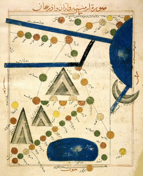 Fig. 5 – Istakhrī’s tenth century AD map entitled Armenia, Arran and Azerbaijan.
From the original manuscript kept in the Iran-Bastan museum, Tehran.
Even from the first glance it is apparent that this is a road map, one of the first in its kind, and certainly one of the first made for use by the general public. The Caspian Sea , on the right part of the map can be seen fed by the rivers Kura and Arax from the west and Sefid-Rud (White river) from the south. The large oval shape lake is Lake Urmiya in Iran. The highest peaks of the region are shown, including Mount Sabalān (Savalan) in Azerbaijan, at the center and the twin peaks of Mount Ararat in Armenia, located lower left. This could be considered as one of the first Islamic road maps. The cities of each country are shown along more or less straight lines, except in the far north. On the map these cities are shown more or less equidistant, irrespective of their real distance from each other and are joined by a straight lines, representing the through road connecting them. The important factor here is the sequence of the cities rather than their respective distances and exact locations.
In Caucasian Albania or Arrān, the road begins at Shabervān near Baku and passes through the cities of Shirvān, Shamakhi, Bardah, Ganja, Shamkhur, Qal’a (Gardabani) and Tiflis. Most of these towns are in the territory of present day Republic of Azerbaijan.
In the territory of Armenia, western part of the map, one road travels southwest from Bardah trough Sihsan (?) terminating in Debil (Dvin in Armenia). Another road starts in the south-west, lower left of the map, going north-east from Amid through Miāfārqin (Tigranakert), Bitlis, Khlāt, Arjish, Berkrī and thence to the (Iranian province of) Azerbaijani cities of Khoy, Salmās, Urmiya, Dakherghān, Maragha and Khunj, terminating in Ardabil junction.
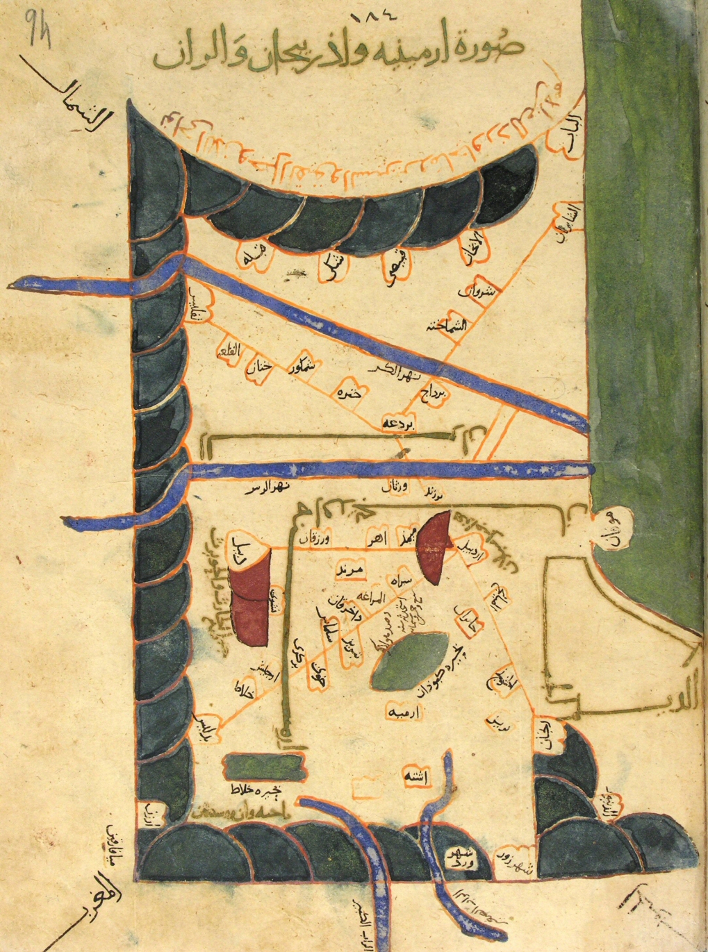 Fig. 6- Istakhrī. Another version of the map of Fig. 5 form a manuscript kept in the Topkapi Museum in Istanbul.
Another map of the same area prepared by Ibn Hawqal is that shown in Fig. 6, which is from the manuscript of Surath ul-Ardh kept in Topkapi Sarāi Museum of Istanbul. Here the mountains are blue and the seas are green. The Caucasus mountain range is shown in the north and the Zagross in the south, connected by the northern Taurus. Azerbaijan is shown south of the river Arax and Armenia at its west. Both Lake Urmiya and Lake Van are shown and here again the cities of the region are aligned on straight lines, with orange interconnecting roads. On this map too the cities are shown equidistant and in sequence. In both the above maps the road lines are either vertical, horizontal or inclined 30-45 degrees.
Yet other sample of the same map, drawn by al-Muqaddasī is shown in the following Fig. 7.
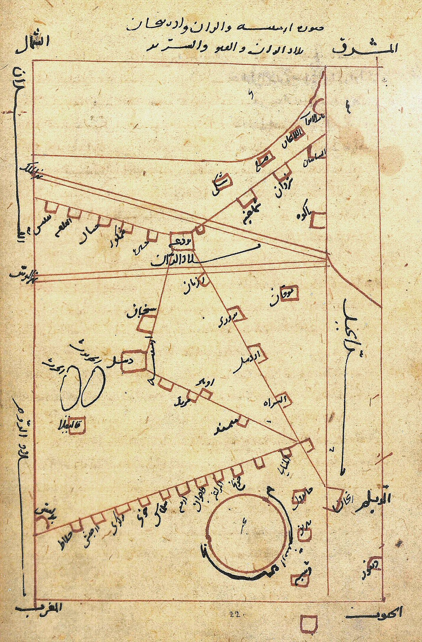 Fig. 7- Al-Muqaddasī. Tenth century AD map of the same area from a manuscript kept in Stadtsbibliothek, Berlin.
This map is a simpler version, with red lines and black legends. The cities, shown as rectangles, are interconnected with red lines and the large circle in the south is entitled “Buhayre Arminiye” (Armenian lake or lake Van). The angles of the roads chosen by the mapmakers are more liberal and varied, but the same approach of equidistant location of the cities and straights interconnecting road lines are once again used.
The above maps show us that the first road maps made for the public use were those made by the Islamic mapmakers of the Balkhī school and that their approach was very innovative, in fact these mapmakers were so much ahead of their time that the next map drawn based on the same principle was in 1931, almost 1000 years later. This was the London Underground map designed and drawn by an electrical draftsman named Harry Beck. His design was eventually adopted by the London Transport and is now used worldwide for showing the routes of most public transport systems in the world.
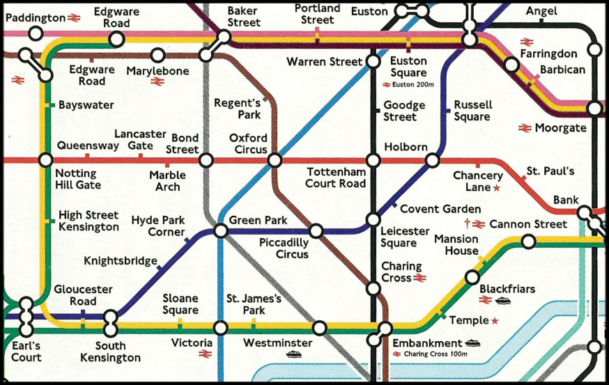 Fig. 8- Part of the London Underground map developed by Harry Beck.
 Fig. 9 – Moscow metro map.
So far only Islamic maps of the area of Azerbaijan, Armenia and Arrān have been shown, but as depicted on the following two images (Fig. 10 and 11) on many Balkhī school geographical manuscripts of the time the very same principle has been applied to other regional maps of the Islamic world. In the following two figures we can see maps of the Iranian provinces of Kirman and Fars, where the cities and the roads appear in the same manner, equidistant but sequentially aligned on mainly straight lines or roads, making these maps part of the first general road maps known to have been made.
These principles were later used by Matthew Paris during the thirteenth and John Ogilby in the seventeenth centuries, paving the way to the development of the modern road maps used by almost every motorist in the world. As for their design, an idea that was developed during the tenth century Persia is now being applied all over the world for showing public transport systems, making direction and destination finding much easier for the map user.
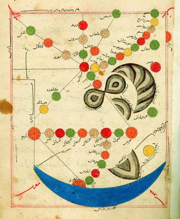
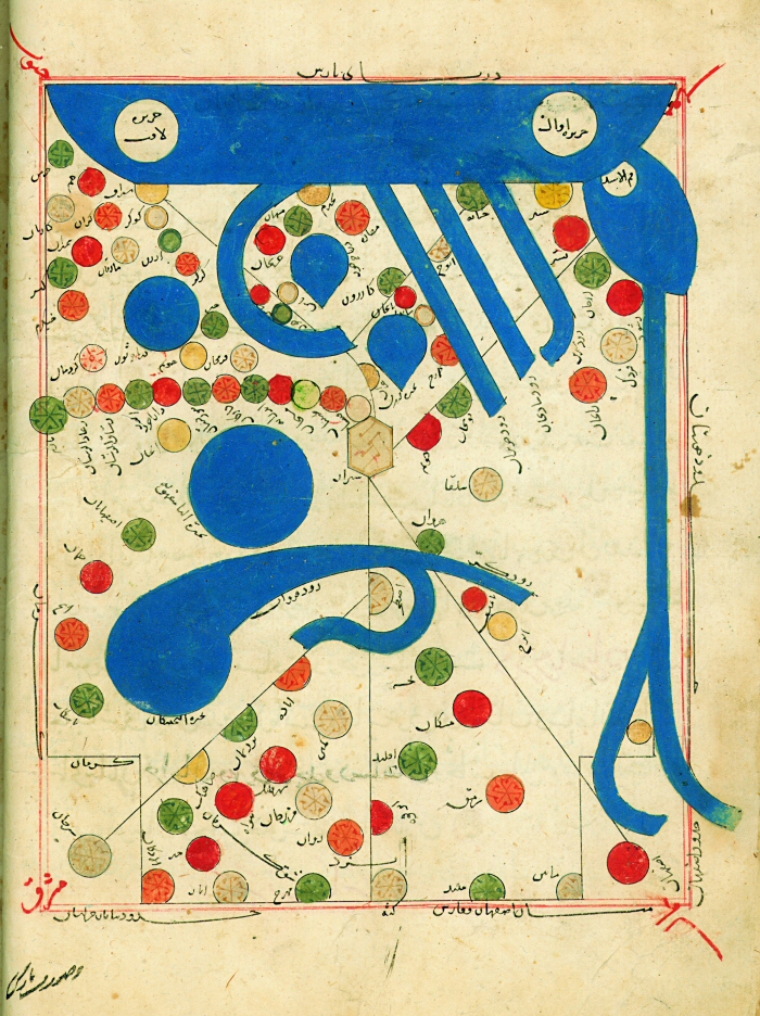
Fig. 10 and 11. Maps of the Iranian provinces of Kirman (right) and Fars (left) by Istakhrī.
From a fourteenth copy manuscript in Iran-Bastan museum in Tehran.
ENDNOTES
[1] J.B. Harley and David Woodward, History of Cartography, Vol. 1, Chicago: University Press, 1987, 238-242.
[2] For details of these maps see Rouben Galichian, Countries South of the Caucasus. Armenia, Georgia and Azerbaijan, (London: Gomidas Institute and Yerevan: Printinfo Art Books, 2007, Chapter 3, 82-113.
[3] Firuz Kazemzadeh, Struggle for Transcaucasia, Oxford: 1951.
[4] Western T-O maps generally are drawn with East at the top, while the Islamic maps have South at the top.
© Rouben Galichian
The Copyright of this article belongs to Rouben Galichian.
Published in Echo of Islam, Tehran, No. 219, August 2009, pp. 22-27.