A MEDIEVAL ARMENIAN T-O MAP
Rouben Galichian
The Matenadaran archive collection in Yerevan, capital of Armenia, contains some 14,000 manuscripts from the golden age of Armenian literature, beginning in the fifth century and from later periods.[see endnote 1] Amongst these manuscripts are many illustrated works on astrology and astronomy as well as some on geography, but virtually nothing contains a map. The oldest geographical work originates from as early as the fifth century and is titled in Armenian Āshkhārhātzūytz or ‘Mirror of the World’. One full and almost sixty abridged manuscript copies of this work have survived, thirty-three of which are in the Matenadaran.[2] The text of this manuscript is based on the work of Pappus of Alexandria (late third or early fourth century), but the chapters relating to Armenia and neighbouring countries have been expanded.[3] A later version of Āshkhārhātzūytz by the thirteenth century historian and geographer Vārtān Āreveltzi is also extant in number of copies (MS No.3119, No. 4184 and others). Both early and later versions display the influence of Ptolemy, and as in the case of Ptolemy, no maps accompany these manuscripts.
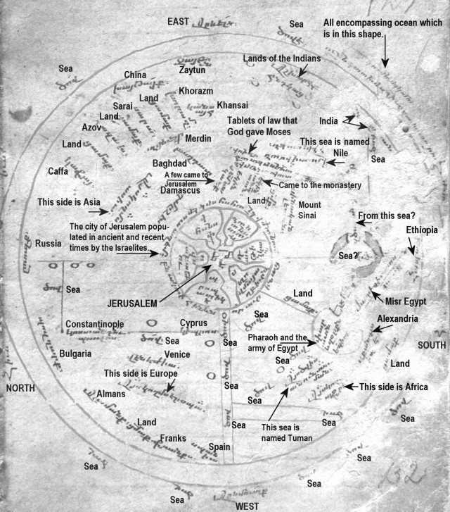
One exception to the general lack of maps in the Yerevan archives is MS No.1242, a collection of eighteen unrelated articles on religious, moral, mathematical and astronomical subjects dating mainly from the thirteenth to the fifteenth centuries. The manuscript is in various hands and has been written on paper. There are 205 numbered leaves, each measuring about 16.5 × 12.5 cm. Folio 131v contains a table of angles of the elevation of the solar orbit. The facing page, folio 132r, bears the circular world map. On the verso of the map page (on 132v) is the beginning of an article on mathematical riddles.[4] The map has no obvious relation to anything else in the volume. This map is believed to be the oldest Armenian language map in existence (Fig. 1 and Plate 1). Its presence in the manuscript raises questions about how such an essentially non-Armenian style map came to be made by an Armenian, and when, considering that this is the only T-O type map known to exist bearing Armenian inscriptions.

The Map
The map on folio 132r can be described as of the T-O type, but its construction has been modified. The O, formed by two circles drawn in red, measures 12.5 cm and 11.3 cm in diameter respectively, with the size of the larger circle being dictated by the width of the page. The horizontal arms of the letter T (stretching north and south fro Jerusalem at the centre) are not represented by the rivers Tanais (Don) and Nile, as in conventional T-O maps, but by single red lines ruled, it would seem, to demarcate Asia from Europe and from Africa. Only the northern end of the single red line might be considered to represent the river Tanais, the traditional divide between Europe and Asia. Two vertical parallel red lines (running from Jerusalem to the western edge of the map), represent the unnamed Mediterranean Sea that separate Africa and Europe. In accordance with the Western Christian T-O maps, the Armenian map is oriented with east at the top.
Also as in many maps of the T-O genre, the centre is occupied by the Holy City of Jerusalem, which is shown with its six gates, each inscribed with its name in Armenian. The circular legend around the city reads ‘The city of Jerusalem populated in ancient and recent times by the Israelites’.[5] The considerable prominence given to Jerusalem can be explained by the fact that the Armenian Church had, and still has, close ties with the Holy City and is one of the four custodians of the Holy Places, with a church, seminary and religious order active since the fifth century.[6]
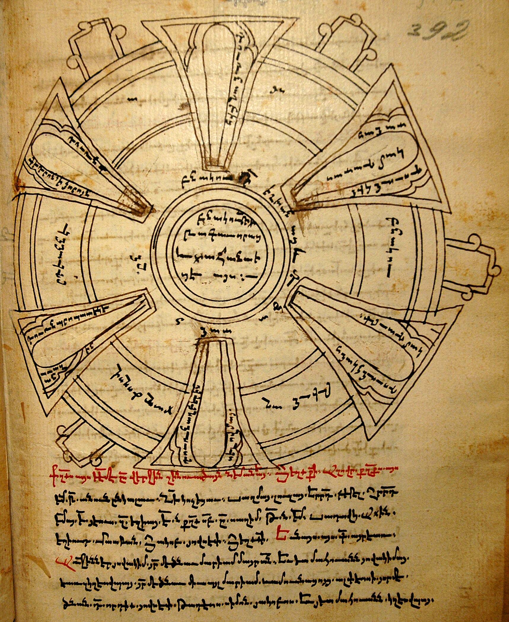
In both shape and arrangement, the city sign is akin to that on the Hereford mappa mundi (c.1290), although it lacks the enclosing crenellated walls of the Hereford map sign. It also resembles the plan of Jerusalem in another Armenian manuscript in Matenadaran, the much later MS 1770 (Fig. 2)[7]. Although made in geographically widely separate locations, a common source or tradition may be suspected, especially were the Armenian map to prove to have been made before the end of the thirteenth century, which would put all these maps to within 100 to 150 years of each other. The city plan in the sixteenth century MS.1770 also would seems to have been derived from the same common source or tradition.
In addition to Jerusalem, twenty-seven other place-names are found on the map (Table 1). Additionally, a number of descriptive legends are inscribed outside and inside the map proper. Outside the double-circle frame of the map are the names of the four cardinal directions Hyūsis, Hārāv, Ārevelq and Ārevmūtq and the word Dzov (Sea) is written seven times.[8] The significance of the two circles is made clear by the note, also on the outside, ‘The all encompassing ocean, which is in this shape’.[9] The term ‘Sea’, it should be noted, as used on the Armenian T-O map, refers any substantial body of water, whether it be an ocean, sea, lake or river. Similarly the term ‘Land’ does not denote a territory as such, but is placed wherever there is a significant gap between neighbouring toponyms.
The least ambiguous continental division on the Armenian map is between Africa and Europe. This is shown by the pair of vertical red lines that descend from Jerusalem in the centre to the outer Ocean and represent the Mediterranean, which is identified only by the word ‘Sea’. The Mediterranean contains four circular islands represented by small black circles. One circle, well to the north of the parallel lines is labelled Kipros (Cyprus). The other three are unnamed. One of these is located at the eastern extremity of the Mediterranean Sea, within the parallel lines, whereas the other two lie just to the north of the lines.
The inscription to the left of the stem of the ‘T’, below the triangle formed by three dots, reads, Āys koghms Eropā (This side is Europe). Around the periphery are the names of three nations, those of the Būlghārq (Bulgars), Ālāmānq (Germans), and Frānks (Franks), and one country, Spāniā (Spain). Further in from the Ocean two cities are named, Kostāndnūpolis (Constantinople) and Venejia (Venice). The selection of these two cities within Europe was unlikely to have been accidental. Venice was an important entrepôt for Armenian merchants, and Constantinople, capital of the Byzantine Empire, was the most important religious and political centre outside Jerusalem.
The legend at the right of the ‘T’ reads Āys koghms Āfrikā (This side is Africa). Between this inscription and the Mediterranean, that is in western Africa, is a small circle that, being inland, can only denote a lake. Indeed, that is how it is identified, with the phrase Āys dzovis ānūnn Tūmān (This Sea is named Tuman). West of this water body, an unnamed river is shown by a pair of parallel red lines bearing the simple inscription ‘Sea’. These lines, drawn almost at right angles to the Mediterranean, connect with the outer Ocean. On the other (eastern) side of the legend indicating Africa a large red circle contains the inscription Pārāvon yev zōrqn Yēgiptosi, (Pharaoh and the army of Egypt). To the right of this is the city of Alexandria (named Skāndāriā). The [Red] Sea ([Kārmir] dzov) is shown as a bold open circle on the borders of Africa and Asia. It is outlined in black, coloured solidly in red, and interrupted as if to indicate the traditional crossing of the Israelites as they fled from Egypt.[10] South-east of this sea the inscription reads Misr-Yēgiptos. Misr is the Arabic name of Egypt, used also in old Armenian, which the mapmaker has chosen to use in conjunction with the latter day Armenian name of the country. Directly south of the Red Sea we see Ethiopia, named Hāpāsh, appearing near the shores of the surrounding Ocean. The Nile is shown well inside Asia, where a vertical (east-west) red line running from close to the eastern Ocean towards the Red Sea bears the legend Āys dzovis ānūn Nīl āsen (This Sea is called Nile).
The division between Europe and Asia, normally marked with the horizontal crossbar of the T, here is demarcated with a single red line and is more complex. Two black lines, drawn at right angles to each other and to the red lines of the continental division and the Mediterranean, indicate the Aegean and Black Seas. A gap in the horizontal line for the Aegean, filled with the name Kostāndnūpolis (Constantinople), seems to imply that the horizontal line also represents the Dardanelles, the Sea of Marmara and the Bosphorus. North of Constantinople, the vertical black line, inscribed only as ‘Sea’, represents the Black Sea. The northern extremity of the red line dividing Europe and Asia, beyond the eastern end of the Black Sea, must also stand for the Sea of Azov (for which there is no place-name) and the river Tanais. Three unnamed islands are shown in this area, all at the eastern end of the Black Sea. The whole representation may be highly schematic, but the way the Aegean Sea is shown as branching off from the Mediterranean, to the west of Jerusalem, and the east–west alignment of Black Sea drawn at right angles to the northern end of the Aegean, near Constantinople, presents a more faithful picture of reality than many other T-O maps.
In keeping with T-O maps in general, the greater part of the Armenian map is allocated to Asia, inscribed Āys kōghms Āsiā (This side is Asia). In the north, following the curve of the encircling Ocean, and on the borders of Europe and Asia, is written Rūsq (Russia). East of Russia a series of place-names is inscribed at right-angles to the circle: Kāfā (Caffa, the name given by the Italians to the Greek Crimean city of Theodosia), Tzāmāq (Land), Āzāch (the city of Azov), Tzāmāq (Land), Sārā (Sarai), Tzāmāq (Land), Khorāzm (or Oxiana) and finally, placed horizontally near the top of the map Kānsāih (Khansai, a trading city in China).[11] By adding the word ‘Land’ between the toponyms, the mapmaker has tried to show that although these towns are widely separated and distant from each other, they constitute a chain of cities along a route that can only be the Silk Road.
In the east, in the upper part of the map close to the Ocean are the names Khāytāi, (China) and Zāytun, another Chinese trading port city.[12] Then comes Āshkhārq Hndkātz (Lands of the Indians), followed well to the southeast by Hndkāstān (Hindustan, India). In the Middle Ages, the designation ‘India’ was used loosely to refer to the lands east of Persia, Media and the Middle East, so here ‘Lands of the Indians’ most probably refers to the northern and western neighbours of India, such as Persia and its neighbouring countries while Hndkāstān “Hindustan or India” denotes India proper.
The presence of these toponyms in the area between Europe and China bears witness to the importance of these towns and provinces in trade and commerce between East and West and is perhaps indicative of the period of the map’s creation. It may also be that this is the earliest that the toponyms Caffa, Azov, Sarai, Zaytun and Khansai are found on any Christian map.[13] Finally, towards the centre of the map we see the cities of Merdin (Mardin), Bāghdāt (Baghdad) and Dmshkh (Damascus), all of which were important trading centres.
Dating the Map
The dating of this map has been controversial; there are suggestions by two Armenian geographers, varying from 1206 to middle of the fourteenth century. Mkrdich Khachaturian’s suggestion that the map dates from 1206 is unlikely to be correct.[14] His conjecture was based on the assumption that all the toponyms on the map are contemporary with the time of its creation and furthermore he claims as the city of Merdin appears prominently on the map, this must have been made prior to the conquest of the city by the Arabs, which took place during the early thirteenth century. These are doubtful lines of argument. On the contrary, information took time to be disseminated, and maps were only slowly updated. Moreover, in the case of the Western mappaemundi the very essence of the map was precisely the inclusion of old (historical as well as biblical) information together with contemporary places and events. It was usual for medieval maps, in short, to depict conditions in existence some time prior to their creation. There is nothing, then, untoward in the inclusion on the Armenian map of Sārā (Sarai), a city founded only in the 1240s by Batu Khan, the grandson of Mongol Empire’s leader Gangiz Khan, who took over the territory of Southern Russia and its Turkic speaking peoples during the early thirteenth century. A fact confirmed by the Flemish Franciscan traveller William de Rubruck (1220–1293), who in 1253 travelled to the region and stated that the Mongol’s capital city of [Sarai] Batu, was one of the most important cities of the region.[15] This posed a problem for Khachaturian, however, and he therefore had to insist that the toponym Sārā related not to Sarai-Batu but to some other location, perhaps a putative island in the Caspian Sea, even though the Caspian is neither mentioned on the map nor has it ever had an inhabited island named Sārā.
Khachatourian also proposes that based on palæographic evidence, the map was made in the Cilician Kingdom of Armenia during the Crusades, unfortunately not specifying which Crusade? It is hardly possible to precisely date a manuscript based on palæography and furthermore, the script used on the map is very similar to another manuscript produced in Caffa in 1445 (Matenadaran, MS. No.8963), which is another collection of astrological and scientific subjects, with diagrams and calendars.[16] Looking at the toponyms shown on the map the questions arises why a Cilician-Armenian mapmaker would include the names of cities along the distant northern Silk Road on his map, at the expense of all the toponyms in his locality. Based on the above arguments it is suggested that this argument too lacks proper foundation.
Caffa, the first town listed in the row of toponyms along the north-eastern periphery of the map, was only a small Crimean seaside town until the thirteenth century. Only during the late thirteenth century, after Genoese merchants leased the town from the Mongols, was it transformed into a flourishing commercial centre, trading with the East and rivalling the Venetian-controlled city of Tanais on the Sea of Azov. The earliest mention of Caffa in Armenian literature dates from the middle of the thirteenth century. By the middle of the fourteenth century— by when there were numerous monastic scriptoria were in operation— the majority of Caffa’s population of 70,000 were Armenian.[17] The presence of the city’s name on the map is a strong indication that the map was made during the city’s heyday, namely in the fourteenth century. Such a date would fit the suggestion that the Armenian mapmaker, who was most likely to have been a monk, either saw or was told about contemporary Italian T-O maps in Caffa, a city not only administered by the Genoese, but also to all intents and purposes functioning as an Italian city, and one of the most suitably located Armenian communities for intellectual as well as commercial contact with the West.[18]
Since, in my view, the map has to postdate both the establishment of Sarai-Batu and Sarai-Berke (New Sarai, established 1257–1266) and the time when Caffa became an important conurbation, the map cannot be dated to earlier than the third quarter of the thirteenth century. The other Armenian geographer, Hovhannes Hovhannisian, who also has studied the map, argues that the presence of both the commercial centres of Khorazm (or Oxiana) and Sarai are indicative of the period when the Mongols had close connections with Khorazm (that is, from the 1240s to around the 1360s), which explains the rationale behind Hovhannisian’s dating the map as late as 1360.[19] In my view, the most creditable hypothesis is that the map was created between the late thirteenth and mid fourteenth century, or even slightly later, which is more in line with Hovhannisian’s proposal.
Some Curious Aspects of the Map
While the majority of similar maps produced in the Christian West depict Armenia, Mount Ararat and Noah’s Ark, the Armenian mapmaker has chosen not to mention any of these Armenian features. Other Biblical events and places are shown on the map: Jerusalem, the giving of the Tablets of the Law to Moses, Mount Sinai, and the Red Sea.[20] In addition, two legends in Palestine read Yekin ānāpātn (Came to the monastery) and Yekin Ye[rūsāghe]m sākāvq (A few came to Je[rusale]m).
Monasteries are mentioned on very few Western maps. While the Hereford mappa mundi (c. 1290) and the Sawley map (1180) each show a monastic establishment, the references have been placed on the banks of the river Nile. The Armenian language has a few words, which mean “monastery”, among them vānq, menāstān and ānānpāt. Significantly, in the present context, the usual meaning of the last word is “desert”. The Monastery on the Armenian map is not named but is defined as ānānpāt, which suggests a conscious choice, since on the Hereford map the whole legend reads “Monasteria Sancti Antonii in deserto”.[21] Since the two Western maps and the Armenian map seem to have been made within one hundred and one hundred fifty years of each other, we can see the reference on the respective maps as further confirmation of the possibility of a common source.
In the end, the absence of reference on the Armenian map to Armenia itself or to any of its immediate neighbours, such as Persia and Assyria, is more puzzling. It can plausibly be deduced, that the author was familiar with Central Asia since current trends in commercial and political relations are well represented by the depiction of the Silk Road cities and major trading centres such as Baghdad, Damascus, Constantinople, and Venice. It may also be suggested that the mapmaker was a native of the region, very likely from the fourteenth-century Caffa, then one of the most important Armenian cultural centres and the source of a large number of manuscripts of that date. Arguably, the lack of any references to Armenia itself could be attributed to the fact that he lived far from his homeland and felt no particular affinity with it. The existence of this Armenian language T-O map, though, may be owed simply to the curiosity of an individual whose interest in Western maps and literature would have been a sufficient reason for him to create a map of his own in line with those of the Western mapmakers of the time, leaving us an Armenian map as remarkable for its uniqueness as for the hints it gives of the interconnections underlying the T-O maps and the mappaemundi of the West.
In Asia: |
In Europe: |
In Africa: |
|
| Rūsq Russia | Kānsāih Khansai | Būlghārq Bulgars | Misr-Yēgiptos Egypt |
| Khāytāi China | Zāytun Zaytun | Ālāmānq Germans | Skāndāriā Alexandria |
| Āshkhārq Hndkātz Lands of the Indians | Merdin Mardin | Frānks Franks | [Kārmir] Dzov Red Sea |
| Hndkāstān India | Bāghdāt Baghdad | Spāniā Spain | Hāpāsh Ethiopia |
| Kāfā Caffa | Dmshkh Damascus | Kostāndnūpolis Constantinople | Tūmān Tuman (lake) |
| Āzāch Azov | Nīl Nile | Venejia Venice | In the centre: |
| Khorāzm Oxiana | Sinākān lēārn, Mt Sinai | Kipros Cyprus | Yerūsāghem Jerusalem |
The medieval Armenian T-O Map, believed to be the oldest Armenian language map in existence, which has a diameter of 12.5 cm. Sheet 16.5 × 12.5 cm. East is at the top. The map appears to date from late thirteenth to mid-fourteenth century. It is part of a manuscript collection of diverse works, Yerevan, Matenadaran, MS 1242, fol. 132r.
(Reproduced with the kind permission of the Director of the Matenadaran.)
Notes and References
[1] The Armenian alphabet was invented in the year 405 by St Mesrop. The Bible was translated from Greek by the end of the fifth century, after which followed many religious, philosophical and scientific works translated from Latin, Arabic, Persian and Syriac. In spite of periodic burning and looting by marauding Seljuk Turks, Mongols, Ottomans and other invaders, almost 20,000 Armenian manuscripts still survive in Armenia, many of them beautifully illustrated.
[2] The original Āshkhārhātzūytz is attributed by some to the 5th-century Armenian historian Movses Khorenatzi, while others believe that it is the work of the 7th-century scientist and astronomer Anania Shirakatzi .
[3] Rouben Galichian, Historic Maps of Armenia. The Cartographic Heritage (London, I. B. Tauris, 2004): 15; and Rouben Galichian, Countries South of the Caucasus in Medieval Maps (London, Gomidas Institute, and Yerevan, Printinfo Art Books, 2007), 146–55.
[4] The Armenian script is written from left to right, but the convention in Matenadaran archive is to show verso/recto as a/b, the first two letters of the Armenian alphabet. In this case I am using the v/r convention, in order not to mislead the western readers.
[5] The Armenian phrase reads: Bnākui hīn yev nor āvurātz qāghāq I[srā]letzotz vor ē Yerūsāghem.
[6] It may be worth bearing in mind that for over four centuries, Christianity was predominantly an Asiatic and North African religion, and that the Christian world was not divided into a Latin West and a predominantly Byzantine East until after the Council of Ephesus in 431. Christianity had reached Armenia through the preaching of the Apostles Bartholomew and Thaddeus. It became the state religion in 301, after the conversion of King Tigran III, which makes the Armenian Church one of the oldest Christian denominations. Armenian Christianity’s ties with the Latin churches of the West were severed in 554 over irreconcilable doctrinal differences.
[7] MS 1770 dates from 1589. It contains a collection of religious, geographical, astronomical and historical works. In section XI, containing a text related to the Old Testament, there is circular plan of the city of Jerusalem (folio 392r), which is very similar to the plan of the same city drawn in the center of the World Map of MS. No. 1242.
[8] Because the encircling Ocean touches the edge of paper, the words Hyūsis (north) and Hārāv (south) have had to be split.
[9] The Armenian phrase reads: Hāmādārādz dzovn vor pātē z[yerkir]s āys kērpivs ē.
[10] The legend that appears to refer to the Crossing of the Red Sea is worn and partially illegible.
[11] Caffa is today the Ukrainian city of Feodosia in the Crimean Peninsula. Sarai refers to the old capital of the Mongols; it is either Sarai-Batu (Old Sarai), built in 1240s, or Sarai-Berke (New Sarai), dating from around 1260. These cities were located in the region of Astrakhan, northwest of the Caspian Sea. The fourteenth century Arab traveller Ibn-Battuta (1304–1368/9) describer the port of Khansai (Khansa in Arabic), located not far from Zaytun, another city on the map, as the largest metropolis in China, {Ibn-Battuta, Rehle [Travelogue], translated into Farsi and annotated by Muhammed-Ali Movahhed; 2 vols. (Tehran, Sepehr-Naghsh Publishers, 1990), vol. 2, ch. 29: 202–3}.
[12] Zaytun was the Arabic name given to the port of Quanzhou or Tseu-Tung in the province of Fujian in China. In the Middle Ages it was an important trading post for Arabs and Persians. According to Ibn-Battuta (1304–1368/9), this was the ‘largest port [he] had ever seen, which could easily accommodate over 100 large Chinese junks’, (Ibn-Battuta, Rehle, (see note 11), vol. 2, ch. 29: 290–295). The port was located across the water from the island of Formosa. The thirteenth century traveller Marco Polo mentions the names of the towns of Zai-tun and Kin-sai as being important cities, trading with Japan (Zippangu), as well as with the Arabs and Persians {Marco Polo, The Travels of Marco Polo, translated and edited by William Marsden, (Garden City, NY, Doubleday & Co., 1948), Bk. 2, ch. LXXVII: 245-247 and Bk. 3, ch. IV: 258}.
[13] Zaytun and Khansai appear on the Catalan Atlas of 1375 as Ciutat de Zaytun and Ciutat de Cansay, respectively; Fra Mauro’s map of 1460 contains both toponyms as Çayton and Chansay.
[14] Mkrdich M. Khachaturian, ‘Medieval oval map in Armenian’, in History of Science and Natural Sciences in Armenia, (Yerevan, Academy of Sciences of Armenia, 1976), vol. 6: 213-239 (in Armenian).
[15] Richard Hakluyt, The Principal Navigations, Voyages, Traffiques and Discoveries of the English Nation, 12 vols. (Glasgow, James MacLehouse, 1903): Vol. 1: 271–76.
[16] One of the pages of this manuscript can be seen in Album of Armenian Palæography, by Michael E. Stone, Dickran Kouymjian and Henning Lehmann (Aarhus University Press, 2002): Plate 140.
[17] Soviet Armenian Encyclopaedia, vol. 4 (Yerevan, 1978), 4: 170 (in Armenian).
[18] Vartges A. Mikayelyan, Armenian-Italian Connections: Genoese Documents about Armenians of Crimea (Yerevan, Academy of Sciences of Armenia, 1974): 21–32 (in Armenian).
[19] Hovhanness Hovhannisian, ‘Armenian manuscript map of the world’, in University Scientific Papers 43:1 (Yerevan, 1954): 81–93 (in Armenian).
[20] The legend to the south-east of Palestine, between Mount Sinai and the Nile reads: Tākhtāk orinātz zōr yet[ur] ā[stuā]tz Mōvs[es]i, which translates “Tablets of law that God gave Moses”. The toponyms for Mount Sinai reads – Sinākān lēārn.
[21] The Monastery of St. Anthony appears under ref. 289 in The Hereford Map by Scott D. Westrem, (Brepols, 2001): 129 and on the Sawley Imago Mundi manuscript map, kept in Corpus Christi College, Cambridge, MS. 66: 2.